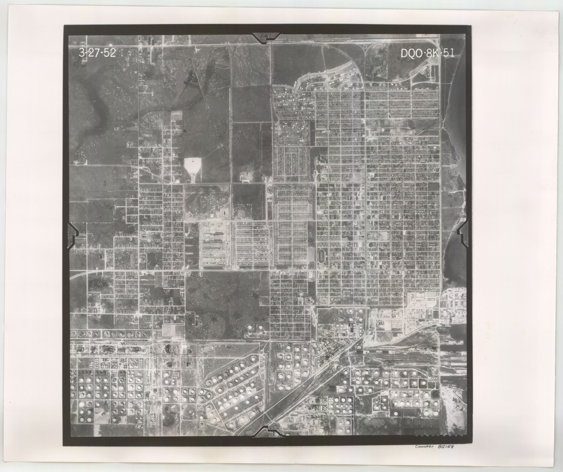
Flight Mission No. DQO-8K, Frame 51, Galveston County
DQO-8K-51
-
Map/Doc
85158
-
Collection
General Map Collection
-
Object Dates
1952/3/27 (Creation Date)
-
People and Organizations
U. S. Department of Agriculture (Publisher)
-
Counties
Galveston
-
Subjects
Aerial Photograph
-
Height x Width
18.7 x 22.3 inches
47.5 x 56.6 cm
-
Comments
Flown by Aero Exploration Company of Tulsa, Oklahoma.
Part of: General Map Collection
City of Austin, Texas and Suburban Territory

Print $40.00
- Digital $50.00
City of Austin, Texas and Suburban Territory
1952
Size 52.9 x 47.2 inches
Map/Doc 73582

Map of Hidalgo County

Print $20.00
- Digital $50.00
Map of Hidalgo County
1880
Size 45.3 x 25.1 inches
Map/Doc 3667
Tom Green County Working Sketch 4

Print $20.00
- Digital $50.00
Tom Green County Working Sketch 4
1948
Size 42.5 x 34.1 inches
Map/Doc 69373
Flight Mission No. BRA-6M, Frame 90, Jefferson County

Print $20.00
- Digital $50.00
Flight Mission No. BRA-6M, Frame 90, Jefferson County
1953
Size 18.5 x 22.2 inches
Map/Doc 85433
Travis County Sketch File 30

Print $6.00
- Digital $50.00
Travis County Sketch File 30
1884
Size 17.0 x 11.0 inches
Map/Doc 38343

Nueces County Sketch File 85

Print $2.00
- Digital $50.00
Nueces County Sketch File 85
Size 11.0 x 8.5 inches
Map/Doc 82922
Brown County Sketch File 10a

Print $6.00
- Digital $50.00
Brown County Sketch File 10a
Size 11.2 x 9.8 inches
Map/Doc 16595
Flight Mission No. DQO-1K, Frame 147, Galveston County

Print $20.00
- Digital $50.00
Flight Mission No. DQO-1K, Frame 147, Galveston County
1952
Size 18.8 x 22.4 inches
Map/Doc 85000
Flight Mission No. DAG-23K, Frame 143, Matagorda County

Print $20.00
- Digital $50.00
Flight Mission No. DAG-23K, Frame 143, Matagorda County
1953
Size 15.8 x 15.7 inches
Map/Doc 86491
Tarrant's Key and Guide to Dallas

Print $20.00
- Digital $50.00
Tarrant's Key and Guide to Dallas
1922
Size 28.1 x 23.2 inches
Map/Doc 89256
You may also like
Llano County Working Sketch 4

Print $40.00
- Digital $50.00
Llano County Working Sketch 4
1954
Size 33.4 x 54.0 inches
Map/Doc 70622
Polk County Sketch File 27

Print $8.00
- Digital $50.00
Polk County Sketch File 27
1891
Size 14.1 x 8.7 inches
Map/Doc 34194
Newton County Sketch File 2

Print $6.00
- Digital $50.00
Newton County Sketch File 2
Size 14.0 x 10.7 inches
Map/Doc 32358
[Sketch showing G. & M. Blocks 5 and M-19 and B. S. & F. Block 9]
![91718, [Sketch showing G. & M. Blocks 5 and M-19 and B. S. & F. Block 9], Twichell Survey Records](https://historictexasmaps.com/wmedia_w700/maps/91718-1.tif.jpg)
Print $20.00
- Digital $50.00
[Sketch showing G. & M. Blocks 5 and M-19 and B. S. & F. Block 9]
Size 22.9 x 17.4 inches
Map/Doc 91718
[Map of the San Antonio del Encinal as Corrected]
![4459, [Map of the San Antonio del Encinal as Corrected], Maddox Collection](https://historictexasmaps.com/wmedia_w700/maps/4459.tif.jpg)
Print $20.00
- Digital $50.00
[Map of the San Antonio del Encinal as Corrected]
Size 28.5 x 30.7 inches
Map/Doc 4459
[Surveys in the Milam District along the Leon River]
![272, [Surveys in the Milam District along the Leon River], General Map Collection](https://historictexasmaps.com/wmedia_w700/maps/272.tif.jpg)
Print $20.00
- Digital $50.00
[Surveys in the Milam District along the Leon River]
1845
Size 12.0 x 15.4 inches
Map/Doc 272
Flight Mission No. BRA-16M, Frame 116, Jefferson County

Print $20.00
- Digital $50.00
Flight Mission No. BRA-16M, Frame 116, Jefferson County
1953
Size 18.5 x 22.3 inches
Map/Doc 85726
Port Aransas-Corpus Christi Waterway, Texas, Avery Point Turning Basin to Vicinity of Tule Lake - Dredging

Print $20.00
- Digital $50.00
Port Aransas-Corpus Christi Waterway, Texas, Avery Point Turning Basin to Vicinity of Tule Lake - Dredging
1947
Size 28.5 x 41.4 inches
Map/Doc 60301
Plat Showing the Construction of Texas & Pacific Ry. Co. Blocks 3 & 4 As Located by G. A. Lider

Print $40.00
- Digital $50.00
Plat Showing the Construction of Texas & Pacific Ry. Co. Blocks 3 & 4 As Located by G. A. Lider
1913
Size 51.4 x 36.3 inches
Map/Doc 89931
Presidio County Sketch File 30

Print $10.00
- Digital $50.00
Presidio County Sketch File 30
1890
Size 10.3 x 8.1 inches
Map/Doc 34468
Gregg County Rolled Sketch RG

Print $20.00
- Digital $50.00
Gregg County Rolled Sketch RG
Size 44.4 x 36.0 inches
Map/Doc 9025
Leon County Working Sketch 12

Print $20.00
- Digital $50.00
Leon County Working Sketch 12
1954
Size 21.9 x 17.1 inches
Map/Doc 70411