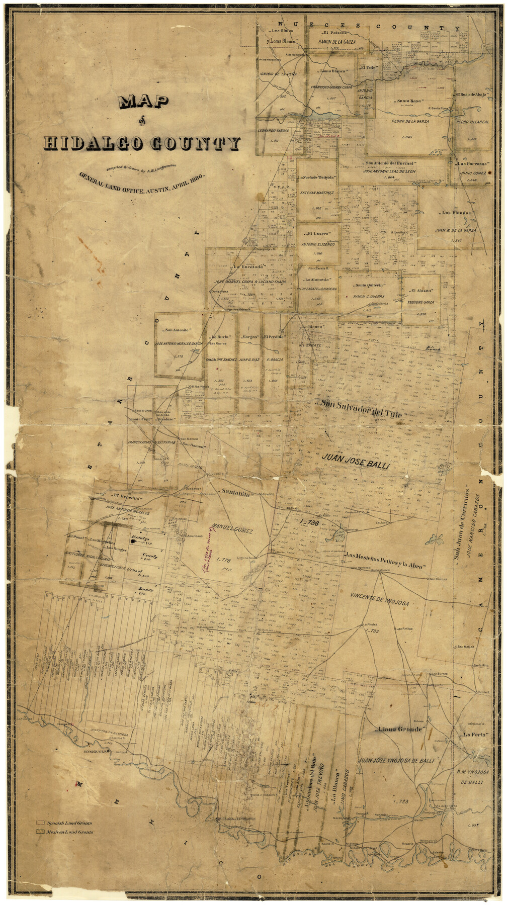
Map of Hidalgo County
-
Map/Doc
3667
-
Collection
General Map Collection
-
Object Dates
4/1880 (Creation Date)
-
People and Organizations
A.B. Langermann (Draftsman)
-
Counties
Hidalgo
-
Subjects
County
-
Height x Width
45.3 x 25.1 inches
115.1 x 63.8 cm
-
Comments
Conservation funded in 2001 with donation from Frost Bank.
-
Features
Rancho San Nicolas
Rancho Los Burros
Rancho Santa Rita
Rancho San Matias
Rancho Las Petitas
Rancho Retama
Rancho Matamoros
Las Cuevas Road
Las Cuevas to La Jara
Rancho La Piedra
Rancho Valla Hermosa
Ranco Santa Monica
Road to las Chiquitas
Rancho Laguna Seca
La Pintoballo
R[anch]o Americano
Rancho La Noria
Rancho La Jara
Austin Road
Austin to El Junco Road
Rancho Guadalupe
Rancho Santanita
Rancho EL Rucio
Cardenaña
Ojo de Agua River
Santa Maria
Rancho Esterito
Rancho Vieja
Rancho Relampargo
Rancho Rosario
Rancho Agua Negre
Rancho Reyes
Rancho Ballie
R[anch]o Blanco
Rancho Naranjado
Rancho Tenajo
Magote San Juan
Ranchito
Rancho Salto
A[rroyo] Colorado
Rancho de Cabasos
Rancho Tampaguas
Rancho Lomitas
Rancho Ebanita
Rancho Colimal
Rancho Penitas
R[ancho] Habana
Rancho Las Cuevas
Lago Tusujal
Noria Salada
Road to las Chiquitas
Purgatorrio
Lago San Juan
Lago Sal Vieja
Lago Sal del Rey
Lago Pintobello
Road to Nopalera
Road to San Colorada
Road to Rio Grande City
El Junco Road
Charco del Pato
Arroyo de las Vacas
Lago Cuates
Lago Suiz
Salt Lake
Laguna Salada
Lago de la Jarita
Lago Tusquita
San Antonio Creek
Los Olmos Creek
Paisano Creek
Palo Blanco Creek
Quiteria Station
Rancho La Jara
Costales
Rancho Juanita
San Jose
Road to Yopalera
San Ramon
Rancho San Jose de Arriba
[Road to] San Colorado
Rancho las Viejas
Arroyo de las Vacas
Las Rucias Rancho
Cibolo Creek
Rancho Gonzalena
Gonzalena [Ranch]
Rancho Tepeguaje
Laguna Sand
Rio Grande del Norte
Edinburgh
Hidalgo
Reynosa Vieja
Sardines Lakes
Cano Lake
Alto Verde
Part of: General Map Collection
Atascosa County Sketch File 2

Print $8.00
- Digital $50.00
Atascosa County Sketch File 2
1847
Size 7.8 x 5.9 inches
Map/Doc 13724
Oldham County Working Sketch 8

Print $20.00
- Digital $50.00
Oldham County Working Sketch 8
1982
Size 33.4 x 35.8 inches
Map/Doc 71330
Anderson County Working Sketch 8

Print $20.00
- Digital $50.00
Anderson County Working Sketch 8
1923
Size 18.6 x 20.6 inches
Map/Doc 67007
Montgomery County Sketch File 25

Print $4.00
- Digital $50.00
Montgomery County Sketch File 25
1839
Size 13.8 x 8.2 inches
Map/Doc 31869
Mason County Boundary File 3

Print $52.00
- Digital $50.00
Mason County Boundary File 3
Size 13.7 x 8.7 inches
Map/Doc 56838
Presidio County Sketch File 78

Print $6.00
- Digital $50.00
Presidio County Sketch File 78
Size 8.4 x 14.3 inches
Map/Doc 34706
Hudspeth County Rolled Sketch 30

Print $20.00
- Digital $50.00
Hudspeth County Rolled Sketch 30
1924
Size 36.0 x 47.3 inches
Map/Doc 9210
Uvalde County Working Sketch 24

Print $20.00
- Digital $50.00
Uvalde County Working Sketch 24
1954
Size 21.7 x 23.3 inches
Map/Doc 72094
Travis County Working Sketch 37

Print $20.00
- Digital $50.00
Travis County Working Sketch 37
1968
Size 12.5 x 12.1 inches
Map/Doc 69421
Map of the River Sabine from its mouth on the Gulf of Mexico in the Sea to Logan's Ferry in Latitude 31°58'24" North

Print $20.00
- Digital $50.00
Map of the River Sabine from its mouth on the Gulf of Mexico in the Sea to Logan's Ferry in Latitude 31°58'24" North
1842
Size 47.9 x 30.6 inches
Map/Doc 87150
Comanche County Working Sketch 32

Print $20.00
- Digital $50.00
Comanche County Working Sketch 32
1992
Size 23.5 x 38.8 inches
Map/Doc 68166
Johnson County Sketch File 25

Print $50.00
- Digital $50.00
Johnson County Sketch File 25
Size 13.9 x 8.3 inches
Map/Doc 28459
You may also like
Matagorda Light to Aransas Pass

Print $20.00
- Digital $50.00
Matagorda Light to Aransas Pass
1965
Size 34.3 x 45.0 inches
Map/Doc 73398
C. A. Pierce's Subdivision of Dick Slaughter Land

Print $20.00
- Digital $50.00
C. A. Pierce's Subdivision of Dick Slaughter Land
Size 37.7 x 17.1 inches
Map/Doc 90301
Upton County Rolled Sketch 32

Print $20.00
- Digital $50.00
Upton County Rolled Sketch 32
Size 38.6 x 39.0 inches
Map/Doc 10049
Flight Mission No. CUG-3P, Frame 42, Kleberg County

Print $20.00
- Digital $50.00
Flight Mission No. CUG-3P, Frame 42, Kleberg County
1956
Size 18.5 x 22.1 inches
Map/Doc 86247
Cochran County Boundary File 2

Print $59.00
- Digital $50.00
Cochran County Boundary File 2
Size 14.8 x 9.3 inches
Map/Doc 51466
Travis County Sketch File 31

Print $4.00
- Digital $50.00
Travis County Sketch File 31
1889
Size 12.9 x 8.8 inches
Map/Doc 38345
Glasscock County Rolled Sketch 10

Print $20.00
- Digital $50.00
Glasscock County Rolled Sketch 10
Size 47.6 x 45.9 inches
Map/Doc 9058
Orange County Working Sketch 21

Print $20.00
- Digital $50.00
Orange County Working Sketch 21
1933
Size 27.0 x 28.1 inches
Map/Doc 71353
Flight Mission No. DQO-7K, Frame 76, Galveston County

Print $20.00
- Digital $50.00
Flight Mission No. DQO-7K, Frame 76, Galveston County
1952
Size 18.8 x 22.5 inches
Map/Doc 85103
King County Boundary File 2

Print $54.00
- Digital $50.00
King County Boundary File 2
Size 8.8 x 7.7 inches
Map/Doc 64887
Map of Hill County

Print $40.00
- Digital $50.00
Map of Hill County
1884
Size 80.1 x 68.0 inches
Map/Doc 82049
Fannin County Sketch File 26

Print $4.00
- Digital $50.00
Fannin County Sketch File 26
1873
Size 8.5 x 10.3 inches
Map/Doc 22495