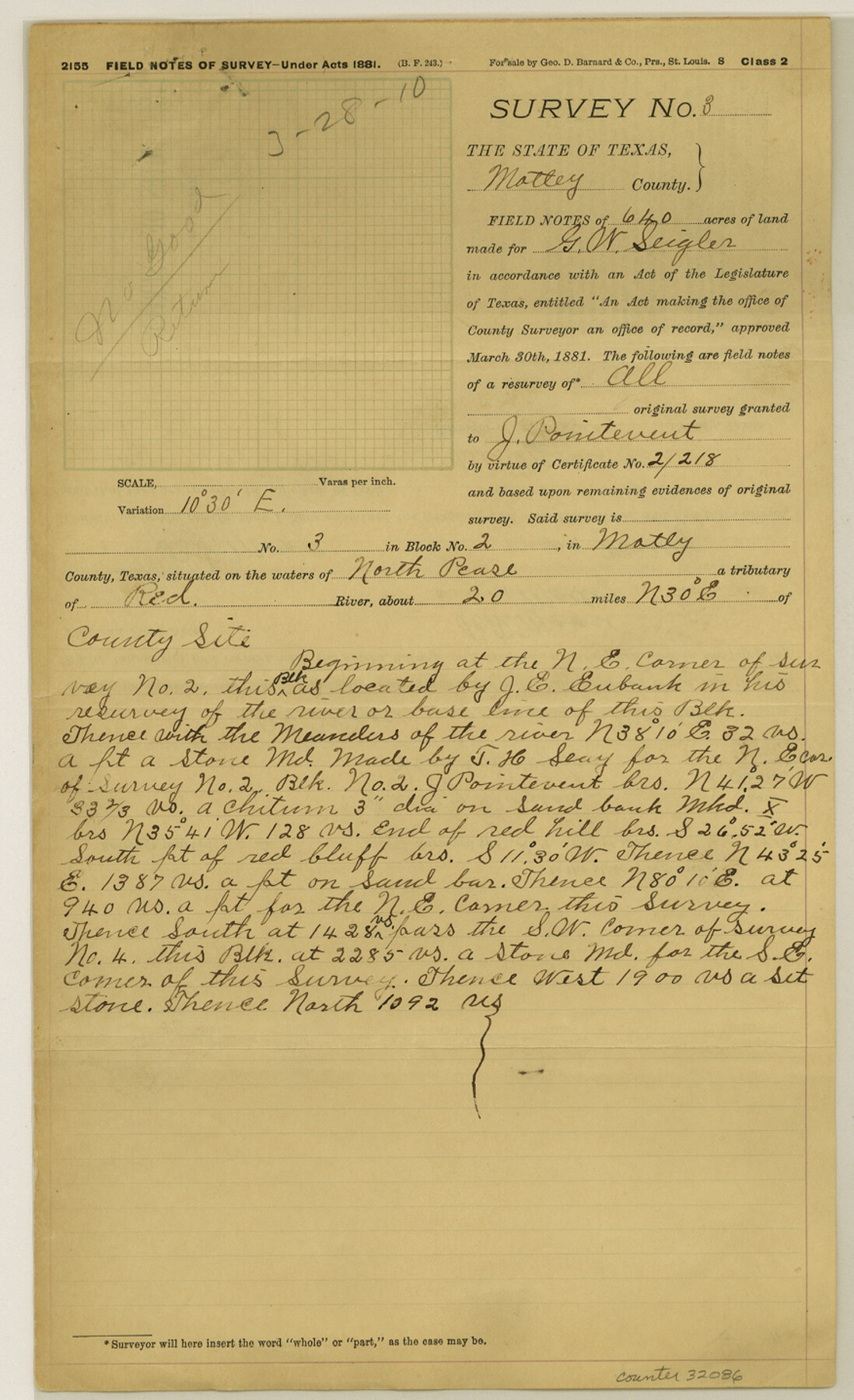
Motley County Sketch File 38 (N)
[Field notes of rejected surveys in Motley County]
-
Map/Doc
32086
-
Collection
General Map Collection
-
Object Dates
7/24/1910 (Survey Date)
7/3/1913 (Survey Date)
3/7/1910 (Survey Date)
2/8/1910 (Survey Date)
3/9/1910 (Correspondence Date)
3/28/1910 (File Date)
1/3/1910 (File Date)
3/23/1910 (File Date)
3/23/1910 (Creation Date)
1/20/1913 (File Date)
1914 (Creation Date)
5/18/1911 (Survey Date)
3/27/1911 (File Date)
9/2/1911 (Correspondence Date)
10/27/1910 (Survey Date)
10/26/1910 (Survey Date)
10/25/1910 (Survey Date)
10/21/1910 (Survey Date)
1/24/1910 (Survey Date)
1914 (File Date)
-
People and Organizations
Oliver Seigler (Chainman/Field Personnel)
B.F. Moore (Surveyor/Engineer)
J.E. Eubank (Surveyor/Engineer)
Henry Taylor (Chainman/Field Personnel)
Alma Siegler (Chainman/Field Personnel)
Jack Killough (Chainman/Field Personnel)
Will Shuman (Chainman/Field Personnel)
R.M. Kenney (Surveyor/Engineer)
Thomas Oates (Chainman/Field Personnel)
I.B. Millican (Chainman/Field Personnel)
T.J. East (Chainman/Field Personnel)
Charles Graham (Chainman/Field Personnel)
Claud Martin (Chainman/Field Personnel)
Joe Shinn (Chainman/Field Personnel)
C.T. Booth (Chainman/Field Personnel)
J.A. Beard (Chainman/Field Personnel)
Lee Head (Chainman/Field Personnel)
John Martin (Chainman/Field Personnel)
P.C. Timmons (Chainman/Field Personnel)
W.L. Moore (Chainman/Field Personnel)
Ned Martin (Chainman/Field Personnel)
Will Brown (Chainman/Field Personnel)
Charles Stradley (Chainman/Field Personnel)
-
Counties
Motley Hall
-
Subjects
Surveying Sketch File
-
Height x Width
14.4 x 8.8 inches
36.6 x 22.4 cm
-
Medium
multi-page, multi-format
-
Features
North Pease River
Tom Ball Creek
Coney Creek
Red River
Linquist Creek
Pole Canyon
Part of: General Map Collection
Martin County Rolled Sketch 11

Print $20.00
- Digital $50.00
Martin County Rolled Sketch 11
Size 19.3 x 25.0 inches
Map/Doc 90051
Matagorda County Rolled Sketch 40

Print $20.00
- Digital $50.00
Matagorda County Rolled Sketch 40
Size 24.6 x 27.4 inches
Map/Doc 6704
Sutton County Sketch File H

Print $22.00
- Digital $50.00
Sutton County Sketch File H
Size 14.3 x 8.7 inches
Map/Doc 37400
Flight Mission No. CLL-1N, Frame 190, Willacy County

Print $20.00
- Digital $50.00
Flight Mission No. CLL-1N, Frame 190, Willacy County
1954
Size 18.5 x 22.2 inches
Map/Doc 87060
Bandera County

Print $40.00
- Digital $50.00
Bandera County
1947
Size 34.2 x 55.3 inches
Map/Doc 95424
Eastland County Rolled Sketch 14

Print $20.00
- Digital $50.00
Eastland County Rolled Sketch 14
Size 18.5 x 18.3 inches
Map/Doc 5775
Wise County Working Sketch 13

Print $20.00
- Digital $50.00
Wise County Working Sketch 13
1971
Size 27.9 x 34.0 inches
Map/Doc 72627
Andrews County Working Sketch 4

Print $20.00
- Digital $50.00
Andrews County Working Sketch 4
1954
Size 42.8 x 19.2 inches
Map/Doc 67050
Sherman County Sketch File 7

Print $2.00
- Digital $50.00
Sherman County Sketch File 7
1993
Size 14.6 x 9.0 inches
Map/Doc 36725
Jack County Sketch File 19

Print $4.00
- Digital $50.00
Jack County Sketch File 19
1878
Size 10.4 x 8.3 inches
Map/Doc 27559
Willacy County

Print $20.00
- Digital $50.00
Willacy County
1921
Size 25.3 x 32.5 inches
Map/Doc 95675
Right of Way and Track Map San Antonio and Aransas Pass Railway Co.

Print $4.00
- Digital $50.00
Right of Way and Track Map San Antonio and Aransas Pass Railway Co.
1919
Size 11.9 x 18.5 inches
Map/Doc 62562
You may also like
Nueces River, Corpus Christi Sheet No. 5

Print $6.00
- Digital $50.00
Nueces River, Corpus Christi Sheet No. 5
1938
Size 28.4 x 33.7 inches
Map/Doc 65094
Cameron County Rolled Sketch 14

Print $53.00
- Digital $50.00
Cameron County Rolled Sketch 14
1954
Size 6.8 x 8.8 inches
Map/Doc 43894
Jack County Working Sketch 2

Print $20.00
- Digital $50.00
Jack County Working Sketch 2
1939
Size 10.9 x 17.7 inches
Map/Doc 66428
Travis County Boundary File 27

Print $2.00
- Digital $50.00
Travis County Boundary File 27
Size 8.4 x 12.9 inches
Map/Doc 59463
[Northern Portion of] Cottle County
![4436, [Northern Portion of] Cottle County, Maddox Collection](https://historictexasmaps.com/wmedia_w700/maps/4436-1.tif.jpg)
Print $20.00
- Digital $50.00
[Northern Portion of] Cottle County
1908
Size 28.4 x 29.5 inches
Map/Doc 4436
Panola County Working Sketch 41

Print $20.00
- Digital $50.00
Panola County Working Sketch 41
1995
Map/Doc 71450
[Maps of surveys in Reeves & Culberson Cos]
![61138, [Maps of surveys in Reeves & Culberson Cos], General Map Collection](https://historictexasmaps.com/wmedia_w700/maps/61138.tif.jpg)
Print $20.00
- Digital $50.00
[Maps of surveys in Reeves & Culberson Cos]
1937
Size 30.6 x 25.0 inches
Map/Doc 61138
Kleberg County Rolled Sketch 11

Print $20.00
- Digital $50.00
Kleberg County Rolled Sketch 11
1915
Size 21.0 x 26.5 inches
Map/Doc 6552
Map of Hardin County, Texas

Print $20.00
- Digital $50.00
Map of Hardin County, Texas
1895
Size 22.1 x 20.9 inches
Map/Doc 499
Kaufman County

Print $40.00
- Digital $50.00
Kaufman County
1942
Size 50.0 x 41.0 inches
Map/Doc 95552
San Augustine County Working Sketch 11a

Print $20.00
- Digital $50.00
San Augustine County Working Sketch 11a
Size 18.8 x 24.4 inches
Map/Doc 63698
Map of Nacogdoches County

Print $20.00
- Digital $50.00
Map of Nacogdoches County
1846
Size 43.9 x 39.7 inches
Map/Doc 87356