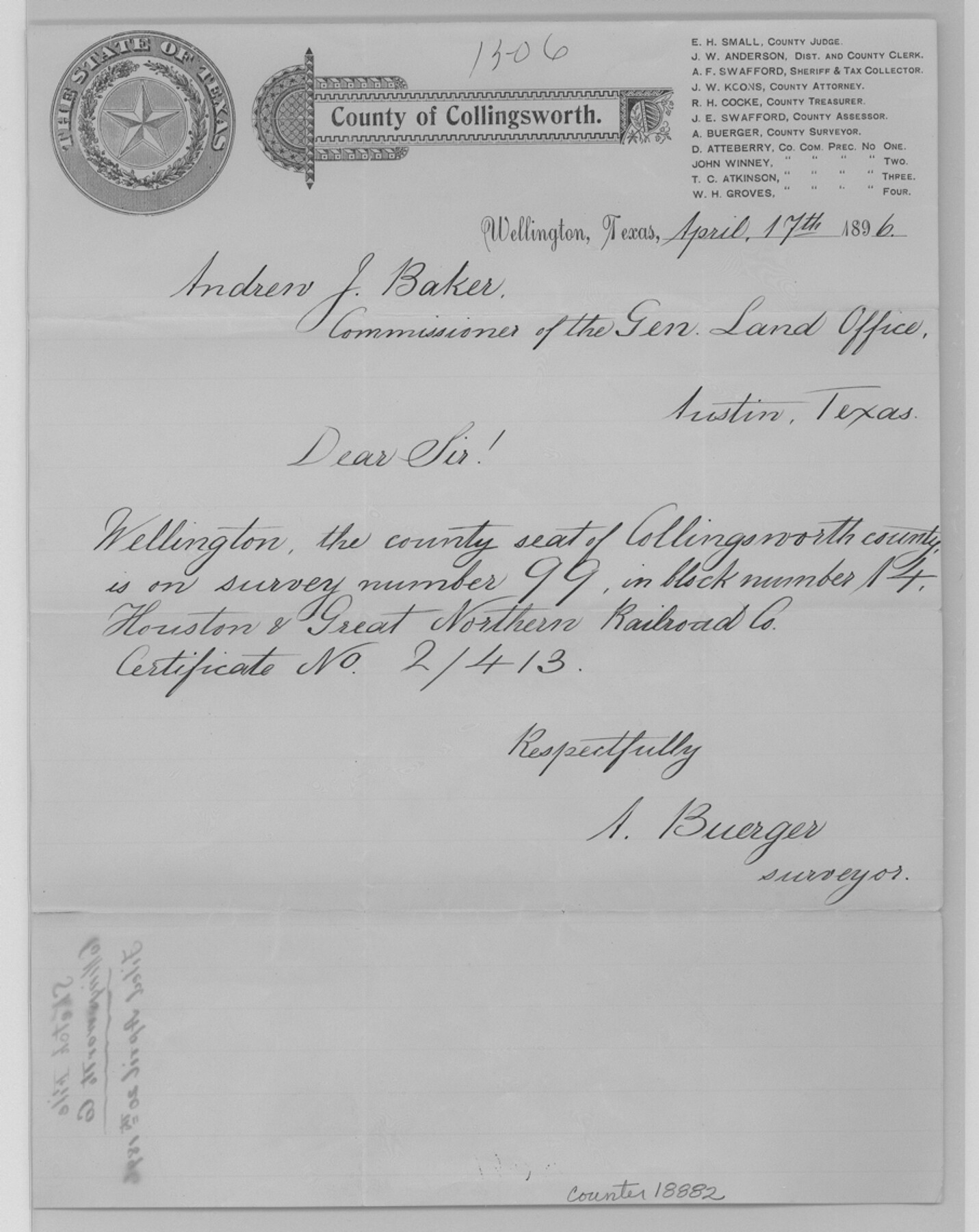
Collingsworth County Sketch File 6
[Letter regarding the location of the county seat]
-
Map/Doc
18882
-
Collection
General Map Collection
-
Object Dates
1896/4/17 (Creation Date)
1896/4/20 (File Date)
-
People and Organizations
A. Buerger (Surveyor/Engineer)
-
Counties
Collingsworth
-
Subjects
Surveying Sketch File
-
Height x Width
11.4 x 9.1 inches
29.0 x 23.1 cm
-
Medium
paper, manuscript
Part of: General Map Collection
Burnet County Sketch File 27a

Print $10.00
- Digital $50.00
Burnet County Sketch File 27a
1876
Size 8.7 x 8.2 inches
Map/Doc 16732
Jim Wells County Working Sketch Graphic Index

Print $20.00
- Digital $50.00
Jim Wells County Working Sketch Graphic Index
1966
Size 41.7 x 29.5 inches
Map/Doc 76597
Township 1 North Range 12 West, North Western District, Louisiana

Print $20.00
- Digital $50.00
Township 1 North Range 12 West, North Western District, Louisiana
1884
Size 19.7 x 24.6 inches
Map/Doc 65877
Live Oak County Sketch File 25

Print $16.00
- Digital $50.00
Live Oak County Sketch File 25
1919
Size 9.0 x 8.5 inches
Map/Doc 30301
Medina County Sketch File 16

Print $8.00
- Digital $50.00
Medina County Sketch File 16
1948
Size 11.4 x 8.8 inches
Map/Doc 31476
Brewster County Working Sketch 24

Print $20.00
- Digital $50.00
Brewster County Working Sketch 24
1939
Size 17.2 x 42.1 inches
Map/Doc 67558
Galveston County NRC Article 33.136 Sketch 71

Print $22.00
- Digital $50.00
Galveston County NRC Article 33.136 Sketch 71
2012
Size 24.0 x 36.0 inches
Map/Doc 94689
Roberts County Working Sketch 5

Print $20.00
- Digital $50.00
Roberts County Working Sketch 5
1949
Size 40.4 x 40.1 inches
Map/Doc 63531
Corpus Christi Bay

Print $20.00
- Digital $50.00
Corpus Christi Bay
1971
Size 36.4 x 47.4 inches
Map/Doc 73472
Gaines County Working Sketch 24

Print $20.00
- Digital $50.00
Gaines County Working Sketch 24
1983
Size 36.4 x 37.9 inches
Map/Doc 69324
Clay County Rolled Sketch 1

Print $20.00
- Digital $50.00
Clay County Rolled Sketch 1
1940
Size 47.0 x 37.9 inches
Map/Doc 8621
Survey plat of lots 2, 4, 6, 8, 10-16, Block 322 of the original town site of Jourdanton known as School File 154507

Print $4.00
- Digital $50.00
Survey plat of lots 2, 4, 6, 8, 10-16, Block 322 of the original town site of Jourdanton known as School File 154507
2001
Size 26.0 x 27.7 inches
Map/Doc 60392
You may also like
Hardeman County Sketch File 14a

Print $20.00
- Digital $50.00
Hardeman County Sketch File 14a
Size 24.4 x 29.0 inches
Map/Doc 11626
Flight Mission No. DQO-8K, Frame 53, Galveston County

Print $20.00
- Digital $50.00
Flight Mission No. DQO-8K, Frame 53, Galveston County
1952
Size 18.6 x 22.3 inches
Map/Doc 85160
Flight Mission No. DQN-5K, Frame 79, Calhoun County

Print $20.00
- Digital $50.00
Flight Mission No. DQN-5K, Frame 79, Calhoun County
1953
Size 18.5 x 22.2 inches
Map/Doc 84412
Goliad County Working Sketch 1

Print $20.00
- Digital $50.00
Goliad County Working Sketch 1
Size 23.7 x 39.9 inches
Map/Doc 63191
[Sketch for Mineral Application 1112 - Colorado River, H. E. Chambers]
![65635, [Sketch for Mineral Application 1112 - Colorado River, H. E. Chambers], General Map Collection](https://historictexasmaps.com/wmedia_w700/maps/65635.tif.jpg)
Print $40.00
- Digital $50.00
[Sketch for Mineral Application 1112 - Colorado River, H. E. Chambers]
1918
Size 25.8 x 48.1 inches
Map/Doc 65635
L'Amerique, divisée selon l[']etendue de ses principales parties, et dont les points principaux sont placez sur les observations de messieurs de l'Academie Royale des Sciences
![95688, L'Amerique, divisée selon l[']etendue de ses principales parties, et dont les points principaux sont placez sur les observations de messieurs de l'Academie Royale des Sciences, Holcomb Digital Map Collection](https://historictexasmaps.com/wmedia_w700/maps/95688.tif.jpg)
Print $40.00
- Digital $50.00
L'Amerique, divisée selon l[']etendue de ses principales parties, et dont les points principaux sont placez sur les observations de messieurs de l'Academie Royale des Sciences
1705
Size 44.9 x 65.4 inches
Map/Doc 95688
Hardin County Sketch File 54

Print $20.00
- Digital $50.00
Hardin County Sketch File 54
1924
Size 16.6 x 17.9 inches
Map/Doc 11635
Rio Grande, Lower Rio Grande Valley/Bulletin 29-A

Print $4.00
- Digital $50.00
Rio Grande, Lower Rio Grande Valley/Bulletin 29-A
1937
Size 12.1 x 24.0 inches
Map/Doc 65103
Orange County Sketch File 1

Print $6.00
- Digital $50.00
Orange County Sketch File 1
Size 9.6 x 11.5 inches
Map/Doc 33299
Yoakum County Sketch File 21

Print $2.00
- Digital $50.00
Yoakum County Sketch File 21
2005
Size 8.5 x 14.0 inches
Map/Doc 83597
[Rusk, Sutton, Garza, and Atascosa County School Lands]
![91125, [Rusk, Sutton, Garza, and Atascosa County School Lands], Twichell Survey Records](https://historictexasmaps.com/wmedia_w700/maps/91125-1.tif.jpg)
Print $3.00
- Digital $50.00
[Rusk, Sutton, Garza, and Atascosa County School Lands]
1913
Size 12.5 x 9.4 inches
Map/Doc 91125
Mitchell County Sketch File 10

Print $4.00
- Digital $50.00
Mitchell County Sketch File 10
1909
Size 11.3 x 8.8 inches
Map/Doc 31698