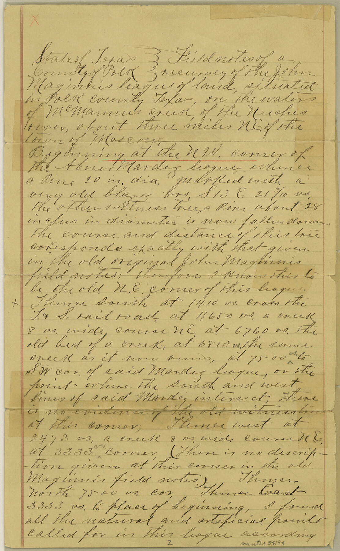
Polk County Sketch File 27
[Field notes of the resurvey of A. Mardez and Jno. Maginnis leagues]
-
Map/Doc
34194
-
Collection
General Map Collection
-
Object Dates
11/15/1891 (Creation Date)
1/11/1892 (File Date)
1835 (Survey Date)
-
People and Organizations
W.H. Matthews (Surveyor/Engineer)
T.D. Maury (Chainman/Field Personnel)
Joe Maury (Chainman/Field Personnel)
-
Counties
Polk
-
Subjects
Surveying Sketch File
-
Height x Width
14.1 x 8.7 inches
35.8 x 22.1 cm
-
Medium
paper, manuscript
-
Features
McMannus Creek
Neches River
Part of: General Map Collection
Leon County Rolled Sketch 26

Print $40.00
- Digital $50.00
Leon County Rolled Sketch 26
Size 24.0 x 54.5 inches
Map/Doc 9435

[Surveyor's certificate by James Howlet, District Surveyor]
![318, [Surveyor's certificate by James Howlet, District Surveyor], General Map Collection](https://historictexasmaps.com/wmedia_w700/maps/318.tif.jpg)
Print $2.00
- Digital $50.00
[Surveyor's certificate by James Howlet, District Surveyor]
Size 6.1 x 8.0 inches
Map/Doc 318
Oldham County Boundary File 1

Print $6.00
- Digital $50.00
Oldham County Boundary File 1
Size 8.8 x 7.2 inches
Map/Doc 57731
Hays County Sketch File 35

Print $4.00
- Digital $50.00
Hays County Sketch File 35
1873
Size 12.8 x 8.2 inches
Map/Doc 26277
Sherman County

Print $20.00
- Digital $50.00
Sherman County
1932
Size 43.1 x 39.9 inches
Map/Doc 63036
Flight Mission No. DAG-18K, Frame 183, Matagorda County

Print $20.00
- Digital $50.00
Flight Mission No. DAG-18K, Frame 183, Matagorda County
1952
Size 16.0 x 16.0 inches
Map/Doc 86375
Upton County Sketch File 13

Print $20.00
- Digital $50.00
Upton County Sketch File 13
1926
Size 34.3 x 37.3 inches
Map/Doc 10414
Frio County Sketch File 22

Print $10.00
- Digital $50.00
Frio County Sketch File 22
1994
Size 11.4 x 8.6 inches
Map/Doc 23162
Polk County Sketch File 22

Print $6.00
- Digital $50.00
Polk County Sketch File 22
1887
Size 8.9 x 7.5 inches
Map/Doc 34173
Calhoun County NRC Article 33.136 Location Key Sheet

Print $20.00
- Digital $50.00
Calhoun County NRC Article 33.136 Location Key Sheet
1973
Size 27.0 x 23.0 inches
Map/Doc 87906
Hudspeth County Working Sketch 39

Print $20.00
- Digital $50.00
Hudspeth County Working Sketch 39
1980
Size 37.1 x 37.0 inches
Map/Doc 66324
You may also like
Clay County Sketch File 46

Print $20.00
- Digital $50.00
Clay County Sketch File 46
1890
Size 18.9 x 19.3 inches
Map/Doc 11098
[Sketch for Mineral Application 36486 and 38244 - Liberty County]
![65621, [Sketch for Mineral Application 36486 and 38244 - Liberty County], General Map Collection](https://historictexasmaps.com/wmedia_w700/maps/65621.tif.jpg)
Print $20.00
- Digital $50.00
[Sketch for Mineral Application 36486 and 38244 - Liberty County]
1976
Size 24.0 x 43.9 inches
Map/Doc 65621
Houston County Rolled Sketch 12

Print $20.00
- Digital $50.00
Houston County Rolled Sketch 12
Size 11.8 x 18.1 inches
Map/Doc 95396
West Part of Edwards County

Print $20.00
- Digital $50.00
West Part of Edwards County
1975
Size 35.5 x 23.2 inches
Map/Doc 77271
General Highway Map, Cherokee County, Texas

Print $20.00
General Highway Map, Cherokee County, Texas
1961
Size 18.2 x 24.7 inches
Map/Doc 79406
Loving County Rolled Sketch 9

Print $20.00
- Digital $50.00
Loving County Rolled Sketch 9
1985
Size 14.2 x 17.3 inches
Map/Doc 6640
Eastland County Sketch File A

Print $20.00
- Digital $50.00
Eastland County Sketch File A
1887
Size 18.1 x 16.8 inches
Map/Doc 11413
Plan of the City of Austin

Print $40.00
- Digital $50.00
Plan of the City of Austin
1840
Size 57.3 x 42.0 inches
Map/Doc 2179
Crockett County Working Sketch 55

Print $40.00
- Digital $50.00
Crockett County Working Sketch 55
1951
Size 51.0 x 37.5 inches
Map/Doc 68388

Sabine County Sketch File 1

Print $2.00
Sabine County Sketch File 1
Size 14.2 x 7.7 inches
Map/Doc 35601
Panola County Working Sketch 16

Print $20.00
- Digital $50.00
Panola County Working Sketch 16
1945
Map/Doc 71425