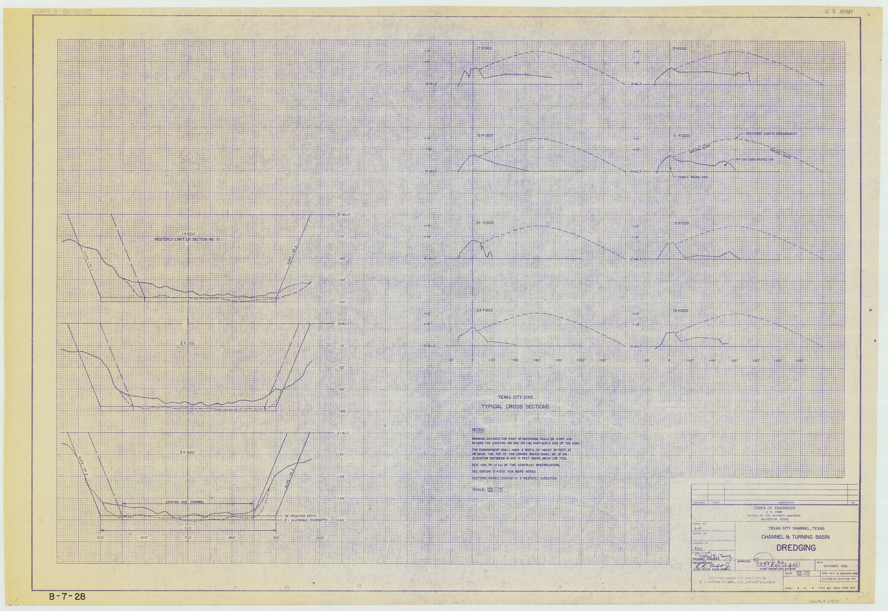
Texas City Channel, Texas, Channel and Turning Basin Dredging - Sheet 5
B-7-28
-
Map/Doc
61835
-
Collection
General Map Collection
-
Object Dates
1958 (Creation Date)
-
Subjects
Intracoastal Waterways
-
Height x Width
28.2 x 40.9 inches
71.6 x 103.9 cm
Part of: General Map Collection
Map of Clay County, Cooke Land District, formely(sic.) Fannin Land District

Print $20.00
- Digital $50.00
Map of Clay County, Cooke Land District, formely(sic.) Fannin Land District
1859
Size 30.2 x 19.0 inches
Map/Doc 1049
Erath County Working Sketch 49

Print $20.00
- Digital $50.00
Erath County Working Sketch 49
1990
Size 37.4 x 30.8 inches
Map/Doc 69130
Harris County Rolled Sketch 86

Print $20.00
- Digital $50.00
Harris County Rolled Sketch 86
1933
Size 33.5 x 32.4 inches
Map/Doc 73575
Presidio County Rolled Sketch MS

Print $20.00
- Digital $50.00
Presidio County Rolled Sketch MS
Size 35.9 x 19.0 inches
Map/Doc 7412
Hansford County

Print $20.00
- Digital $50.00
Hansford County
1932
Size 39.7 x 39.0 inches
Map/Doc 95519
Lamar County Sketch File 3

Print $6.00
- Digital $50.00
Lamar County Sketch File 3
1864
Size 14.2 x 8.6 inches
Map/Doc 29275

Flight Mission No. BQR-20K, Frame 6, Brazoria County

Print $20.00
- Digital $50.00
Flight Mission No. BQR-20K, Frame 6, Brazoria County
1952
Size 18.6 x 22.3 inches
Map/Doc 84108
Old Miscellaneous File 30

Print $16.00
- Digital $50.00
Old Miscellaneous File 30
1845
Size 13.3 x 8.2 inches
Map/Doc 75740
Williamson County Rolled Sketch 6

Print $20.00
- Digital $50.00
Williamson County Rolled Sketch 6
1941
Size 26.0 x 18.9 inches
Map/Doc 8264
Presidio County Rolled Sketch 113

Print $20.00
- Digital $50.00
Presidio County Rolled Sketch 113
1978
Size 22.2 x 27.8 inches
Map/Doc 7389
Shelby County Working Sketch 12

Print $40.00
- Digital $50.00
Shelby County Working Sketch 12
1946
Size 53.4 x 36.4 inches
Map/Doc 63865
You may also like
Flight Mission No. CGI-3N, Frame 130, Cameron County

Print $20.00
- Digital $50.00
Flight Mission No. CGI-3N, Frame 130, Cameron County
1954
Size 18.5 x 22.2 inches
Map/Doc 84603
Crockett County Rolled Sketch 70

Print $20.00
- Digital $50.00
Crockett County Rolled Sketch 70
1949
Size 15.1 x 17.0 inches
Map/Doc 5612
Wharton County Sketch File 14

Print $70.00
- Digital $50.00
Wharton County Sketch File 14
1895
Size 9.7 x 6.2 inches
Map/Doc 39938
The Republic County of Jackson. 1841

Print $20.00
The Republic County of Jackson. 1841
2020
Size 15.6 x 21.8 inches
Map/Doc 96187
Angelina County Sketch File 21b

Print $6.00
- Digital $50.00
Angelina County Sketch File 21b
1889
Size 13.9 x 8.5 inches
Map/Doc 13044
Flight Mission No. BRA-16M, Frame 148, Jefferson County

Print $20.00
- Digital $50.00
Flight Mission No. BRA-16M, Frame 148, Jefferson County
1953
Size 18.5 x 22.2 inches
Map/Doc 85754
[Map showing S. A. & A. P. Ry. from San Antonio to Kendall County line]
![64255, [Map showing S. A. & A. P. Ry. from San Antonio to Kendall County line], General Map Collection](https://historictexasmaps.com/wmedia_w700/maps/64255.tif.jpg)
Print $40.00
- Digital $50.00
[Map showing S. A. & A. P. Ry. from San Antonio to Kendall County line]
1895
Size 25.5 x 70.7 inches
Map/Doc 64255
Childress County Rolled Sketch 9C

Print $20.00
- Digital $50.00
Childress County Rolled Sketch 9C
Size 13.8 x 17.9 inches
Map/Doc 5449
Americae Sive Novi Orbis Nova Descriptio

Print $20.00
- Digital $50.00
Americae Sive Novi Orbis Nova Descriptio
1579
Size 18.0 x 22.9 inches
Map/Doc 93805
Flight Mission No. CUG-2P, Frame 7, Kleberg County

Print $20.00
- Digital $50.00
Flight Mission No. CUG-2P, Frame 7, Kleberg County
1956
Size 18.5 x 22.3 inches
Map/Doc 86179
Hudspeth County Sketch File 25

Print $10.00
- Digital $50.00
Hudspeth County Sketch File 25
1936
Size 11.3 x 8.7 inches
Map/Doc 26979
University of Texas System University Lands

Print $20.00
- Digital $50.00
University of Texas System University Lands
Size 23.0 x 17.5 inches
Map/Doc 93240