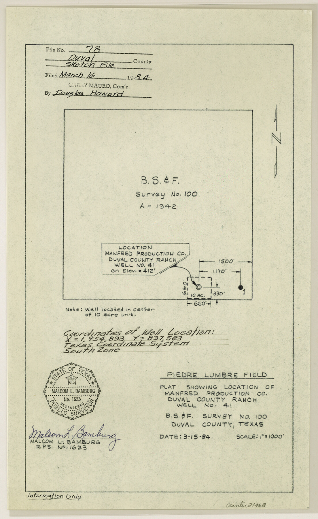
Duval County Sketch File 78
Piedre Lumbre Field - plat showing location of Manfred Production Co. Duval County Ranch, Well No. 41, B. S. & F. survey no. 100
-
Map/Doc
21468
-
Collection
General Map Collection
-
Object Dates
1984/3/15 (Creation Date)
1984/3/16 (File Date)
-
People and Organizations
Malcom L. Bamburg (Surveyor/Engineer)
-
Counties
Duval
-
Subjects
Surveying Sketch File
-
Height x Width
14.5 x 8.9 inches
36.8 x 22.6 cm
-
Medium
blueprint/diazo
-
Scale
1" = 1000 varas
Part of: General Map Collection
Nueces County Rolled Sketch 96

Print $44.00
Nueces County Rolled Sketch 96
1983
Size 24.2 x 36.5 inches
Map/Doc 7053
Fannin County Sketch File 15

Print $6.00
- Digital $50.00
Fannin County Sketch File 15
1866
Size 8.2 x 8.2 inches
Map/Doc 22466
Collin County Boundary File 18c

Print $12.00
- Digital $50.00
Collin County Boundary File 18c
Size 12.9 x 8.1 inches
Map/Doc 51733
Montgomery County Working Sketch 31

Print $20.00
- Digital $50.00
Montgomery County Working Sketch 31
Size 24.7 x 18.7 inches
Map/Doc 71138
Jeff Davis County Working Sketch 19

Print $40.00
- Digital $50.00
Jeff Davis County Working Sketch 19
1957
Size 71.3 x 34.1 inches
Map/Doc 66514
Panola County Working Sketch 29

Print $20.00
- Digital $50.00
Panola County Working Sketch 29
1980
Map/Doc 71438
Map of Harrison County

Print $20.00
- Digital $50.00
Map of Harrison County
1871
Size 18.2 x 19.3 inches
Map/Doc 4561
Briscoe County Rolled Sketch 11

Print $20.00
- Digital $50.00
Briscoe County Rolled Sketch 11
1913
Size 25.0 x 21.6 inches
Map/Doc 5328
General Chart of the Coast No. XVI - Gulf Coast from Galveston to the Rio Grande

Print $20.00
- Digital $50.00
General Chart of the Coast No. XVI - Gulf Coast from Galveston to the Rio Grande
1883
Size 26.8 x 18.1 inches
Map/Doc 72737
Lampasas County Boundary File 4

Print $44.00
- Digital $50.00
Lampasas County Boundary File 4
Size 14.0 x 8.5 inches
Map/Doc 56110
Dimmit County Working Sketch 30

Print $20.00
- Digital $50.00
Dimmit County Working Sketch 30
1957
Size 22.2 x 26.0 inches
Map/Doc 68691
Jeff Davis County Working Sketch 8

Print $20.00
- Digital $50.00
Jeff Davis County Working Sketch 8
1940
Size 45.4 x 42.9 inches
Map/Doc 66503
You may also like
Replat of Baker 2nd Addition to Lamesa, Part of Southwest Quarter, Section 71, Block 35, Dawson County, Texas

Print $20.00
- Digital $50.00
Replat of Baker 2nd Addition to Lamesa, Part of Southwest Quarter, Section 71, Block 35, Dawson County, Texas
1958
Size 9.9 x 18.8 inches
Map/Doc 92633
Flight Mission No. DIX-8P, Frame 57, Aransas County

Print $20.00
- Digital $50.00
Flight Mission No. DIX-8P, Frame 57, Aransas County
1956
Size 18.7 x 22.4 inches
Map/Doc 83888

[Jas. T. Williams Survey]
![91260, [Jas. T. Williams Survey], Twichell Survey Records](https://historictexasmaps.com/wmedia_w700/maps/91260-1.tif.jpg)
Print $20.00
- Digital $50.00
[Jas. T. Williams Survey]
Size 24.0 x 18.4 inches
Map/Doc 91260
Motley County Sketch File 10 (N)

Print $20.00
- Digital $50.00
Motley County Sketch File 10 (N)
1900
Size 14.0 x 8.5 inches
Map/Doc 32026
Flight Mission No. DCL-6C, Frame 2, Kenedy County

Print $20.00
- Digital $50.00
Flight Mission No. DCL-6C, Frame 2, Kenedy County
1943
Size 18.6 x 22.4 inches
Map/Doc 85862
[State Capitol Leagues, County School Leagues, and vicinity]
![92535, [State Capitol Leagues, County School Leagues, and vicinity], Twichell Survey Records](https://historictexasmaps.com/wmedia_w700/maps/92535-1.tif.jpg)
Print $20.00
- Digital $50.00
[State Capitol Leagues, County School Leagues, and vicinity]
1913
Size 20.8 x 27.6 inches
Map/Doc 92535
General Highway Map, Medina County, Texas

Print $20.00
General Highway Map, Medina County, Texas
1940
Size 18.3 x 24.6 inches
Map/Doc 79195
Briscoe County

Print $20.00
- Digital $50.00
Briscoe County
1930
Size 42.0 x 35.8 inches
Map/Doc 73090
Brazoria County Sketch File 52

Print $6.00
- Digital $50.00
Brazoria County Sketch File 52
Size 14.5 x 8.0 inches
Map/Doc 15313
Baylor County Sketch File A6

Print $80.00
- Digital $50.00
Baylor County Sketch File A6
1899
Size 22.5 x 31.7 inches
Map/Doc 10912
Hardin County Boundary File 40

Print $14.00
- Digital $50.00
Hardin County Boundary File 40
Size 9.0 x 3.5 inches
Map/Doc 54409