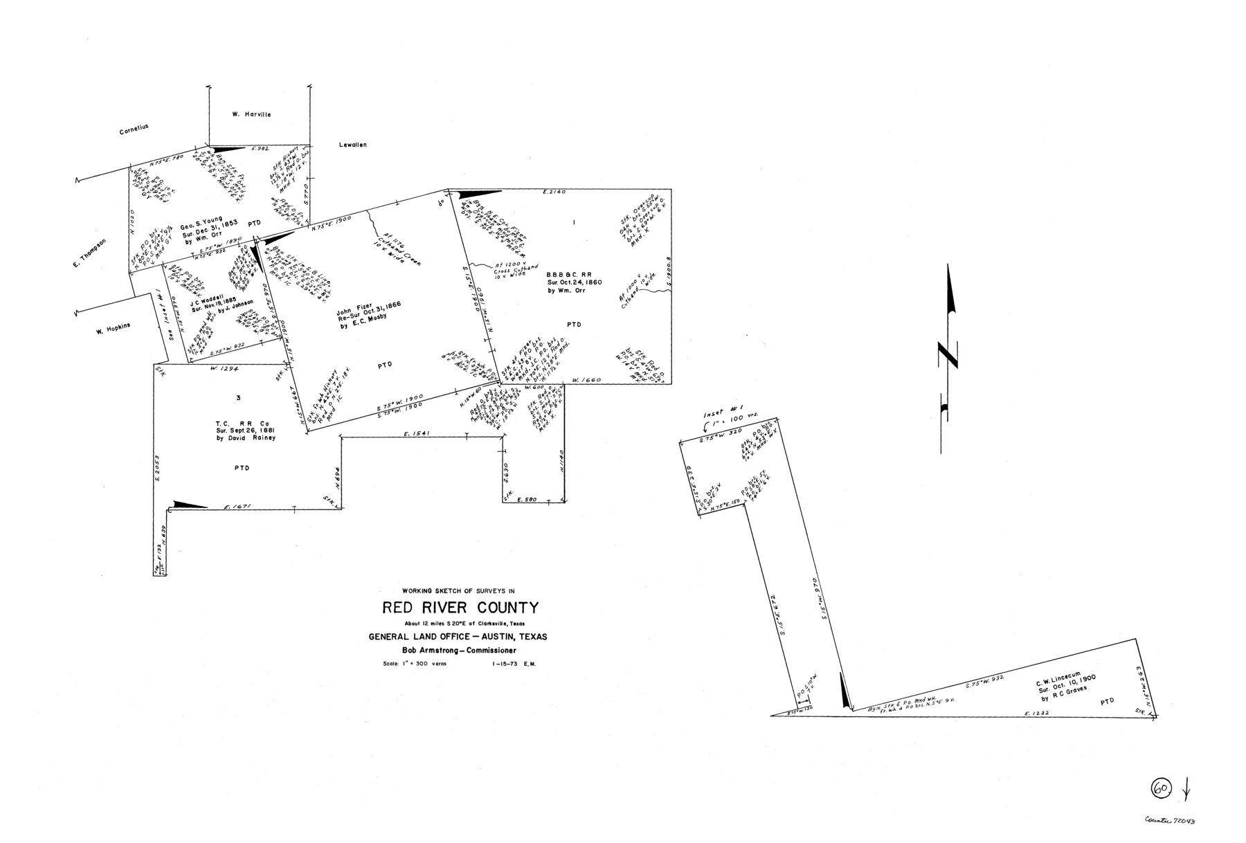
Red River County Working Sketch 60
-
Map/Doc
72043
-
Collection
General Map Collection
-
Object Dates
1/15/1973 (Creation Date)
-
People and Organizations
Elbert Menzel (Draftsman)
-
Counties
Red River
-
Subjects
Surveying Working Sketch
-
Height x Width
27.1 x 40.0 inches
68.8 x 101.6 cm
-
Scale
1" = 300 varas
Part of: General Map Collection
Mineral Plats - El Paso to Ward Co. and River Beds

Mineral Plats - El Paso to Ward Co. and River Beds
Map/Doc 81746
Harris County Working Sketch 27

Print $20.00
- Digital $50.00
Harris County Working Sketch 27
1933
Size 36.9 x 43.0 inches
Map/Doc 65919
Map of the City of Austin Texas

Map of the City of Austin Texas
1933
Size 22.5 x 17.6 inches
Map/Doc 76050
Red River County Working Sketch 81-3

Print $20.00
- Digital $50.00
Red River County Working Sketch 81-3
1987
Size 17.5 x 21.5 inches
Map/Doc 72066
Stonewall County Working Sketch 19

Print $20.00
- Digital $50.00
Stonewall County Working Sketch 19
1957
Size 35.3 x 35.1 inches
Map/Doc 62326

Stephens County Rolled Sketch 2

Print $20.00
- Digital $50.00
Stephens County Rolled Sketch 2
1919
Size 24.8 x 30.3 inches
Map/Doc 7839
Hopkins County Sketch File 2a

Print $4.00
- Digital $50.00
Hopkins County Sketch File 2a
Size 13.6 x 8.6 inches
Map/Doc 26683
Terrell County Sketch File 30

Print $4.00
- Digital $50.00
Terrell County Sketch File 30
1940
Size 11.2 x 8.8 inches
Map/Doc 37979
Wise County Working Sketch 16

Print $20.00
- Digital $50.00
Wise County Working Sketch 16
1960
Size 28.0 x 39.0 inches
Map/Doc 72630

Land Grant Map of Comal County

Print $20.00
- Digital $50.00
Land Grant Map of Comal County
2006
Size 33.3 x 41.0 inches
Map/Doc 83601
You may also like
[H. & G. N. Block 1]
![90945, [H. & G. N. Block 1], Twichell Survey Records](https://historictexasmaps.com/wmedia_w700/maps/90945-1.tif.jpg)
Print $20.00
- Digital $50.00
[H. & G. N. Block 1]
1873
Size 17.4 x 14.1 inches
Map/Doc 90945
Cameron County Rolled Sketch US1

Print $20.00
- Digital $50.00
Cameron County Rolled Sketch US1
1913
Size 21.2 x 25.3 inches
Map/Doc 5399
King County Boundary File 5

Print $12.00
- Digital $50.00
King County Boundary File 5
Size 14.2 x 8.8 inches
Map/Doc 64916
Matagorda County Working Sketch 31

Print $20.00
- Digital $50.00
Matagorda County Working Sketch 31
1982
Size 17.2 x 46.9 inches
Map/Doc 70889
Flight Mission No. DIX-10P, Frame 64, Aransas County

Print $20.00
- Digital $50.00
Flight Mission No. DIX-10P, Frame 64, Aransas County
1956
Size 18.7 x 22.3 inches
Map/Doc 83925
Newton County Working Sketch 31

Print $20.00
- Digital $50.00
Newton County Working Sketch 31
1955
Size 34.3 x 43.6 inches
Map/Doc 71277
[Field Notes attached to Sketch of North Line of Deaf Smith County and South Line of Oldham County]
![91406, [Field Notes attached to Sketch of North Line of Deaf Smith County and South Line of Oldham County], Twichell Survey Records](https://historictexasmaps.com/wmedia_w700/maps/91406-1.tif.jpg)
Print $2.00
- Digital $50.00
[Field Notes attached to Sketch of North Line of Deaf Smith County and South Line of Oldham County]
1894
Size 8.9 x 14.4 inches
Map/Doc 91406
Travis County Rolled Sketch 56

Print $20.00
- Digital $50.00
Travis County Rolled Sketch 56
1885
Size 16.7 x 23.2 inches
Map/Doc 8047
Hall County Sketch File B1

Print $20.00
- Digital $50.00
Hall County Sketch File B1
1904
Size 23.4 x 25.4 inches
Map/Doc 11612
Flight Mission No. DAH-9M, Frame 206, Orange County

Print $20.00
- Digital $50.00
Flight Mission No. DAH-9M, Frame 206, Orange County
1953
Size 18.7 x 22.7 inches
Map/Doc 86874
[Capitol Land Reservation, Brooks and Burleson Blocks 1 and 2, H. & T. C. RR. Company Block 48]
![90773, [Capitol Land Reservation, Brooks and Burleson Blocks 1 and 2, H. & T. C. RR. Company Block 48], Twichell Survey Records](https://historictexasmaps.com/wmedia_w700/maps/90773-1.tif.jpg)
Print $20.00
- Digital $50.00
[Capitol Land Reservation, Brooks and Burleson Blocks 1 and 2, H. & T. C. RR. Company Block 48]
1902
Size 22.0 x 17.1 inches
Map/Doc 90773
Burnet County Boundary File 4

Print $30.00
- Digital $50.00
Burnet County Boundary File 4
Size 8.8 x 8.1 inches
Map/Doc 50872