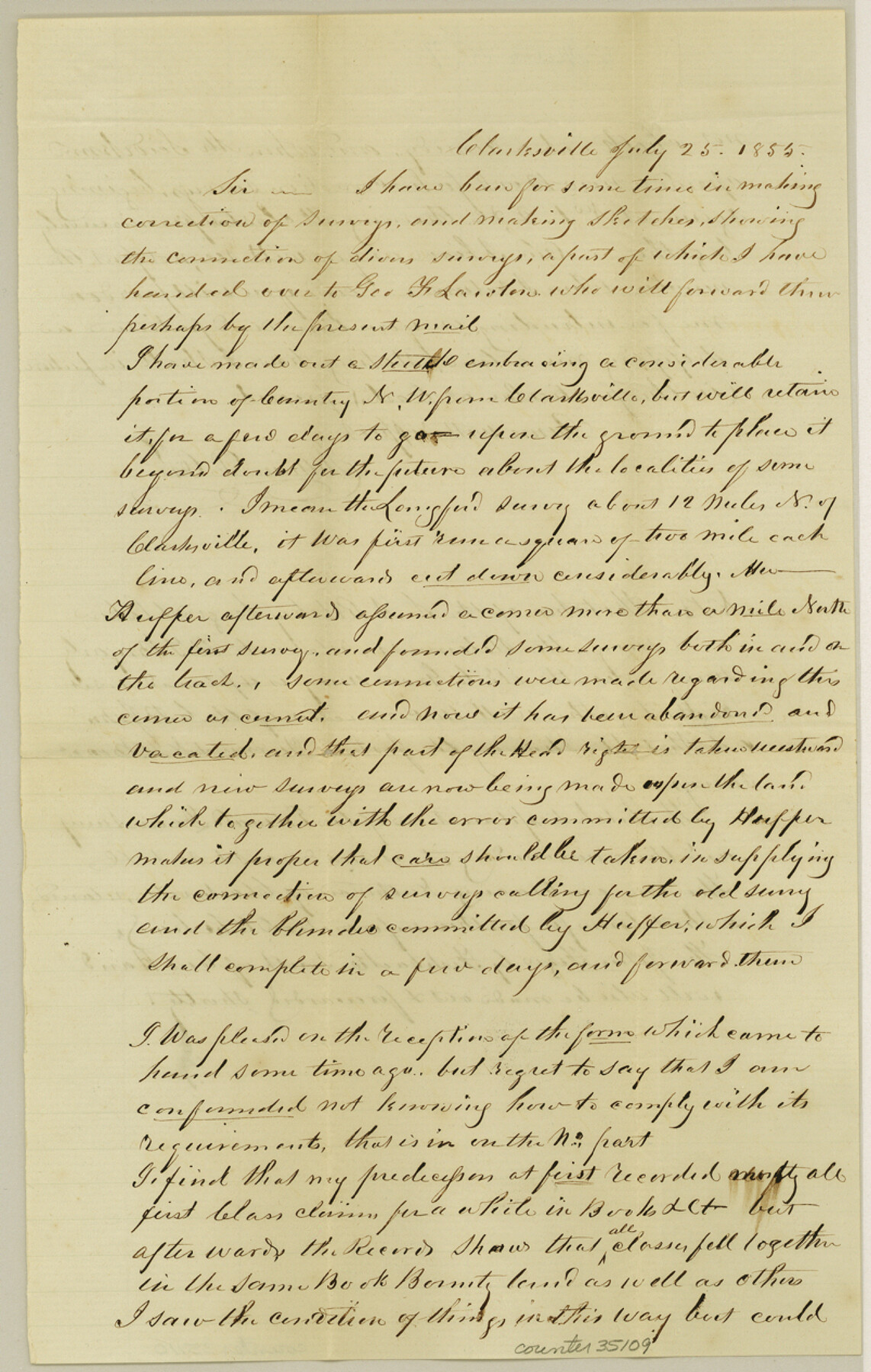
Red River County Sketch File 7
[Letter regarding large area of Red River County northwest from Clarksville]
-
Map/Doc
35109
-
Collection
General Map Collection
-
Object Dates
7/25/1855 (Creation Date)
8/30/1855 (File Date)
-
People and Organizations
William D. Orr (Surveyor/Engineer)
-
Counties
Red River
-
Subjects
Surveying Sketch File
-
Height x Width
12.7 x 8.0 inches
32.3 x 20.3 cm
-
Medium
paper, manuscript
Part of: General Map Collection
Bexar County Sketch File 36c

Print $20.00
- Digital $50.00
Bexar County Sketch File 36c
1874
Size 19.3 x 26.4 inches
Map/Doc 10922
Flight Mission No. DAG-23K, Frame 15, Matagorda County

Print $20.00
- Digital $50.00
Flight Mission No. DAG-23K, Frame 15, Matagorda County
1953
Size 15.5 x 15.3 inches
Map/Doc 86477
Copy of Surveyor's Field Book, Morris Browning - In Blocks 7, 5 & 4, I&GNRRCo., Hutchinson and Carson Counties, Texas

Print $3.00
- Digital $50.00
Copy of Surveyor's Field Book, Morris Browning - In Blocks 7, 5 & 4, I&GNRRCo., Hutchinson and Carson Counties, Texas
1888
Size 12.7 x 9.7 inches
Map/Doc 62258
Map of Montague County

Print $20.00
- Digital $50.00
Map of Montague County
1868
Size 19.9 x 16.9 inches
Map/Doc 3888
Bell County Sketch File 35

Print $40.00
- Digital $50.00
Bell County Sketch File 35
1952
Size 22.0 x 24.3 inches
Map/Doc 10918
[Right of Way Map, Belton Branch of the M.K.&T. RR.]
![64220, [Right of Way Map, Belton Branch of the M.K.&T. RR.], General Map Collection](https://historictexasmaps.com/wmedia_w700/maps/64220.tif.jpg)
Print $20.00
- Digital $50.00
[Right of Way Map, Belton Branch of the M.K.&T. RR.]
1896
Size 22.2 x 7.4 inches
Map/Doc 64220
Runnels County Boundary File 2a

Print $8.00
- Digital $50.00
Runnels County Boundary File 2a
Size 11.5 x 8.8 inches
Map/Doc 58526
Harbor Pass and Bar at Brazos Santiago, Texas

Print $20.00
- Digital $50.00
Harbor Pass and Bar at Brazos Santiago, Texas
1879
Size 18.2 x 27.5 inches
Map/Doc 73000

Lake Worth Boundary

Print $20.00
- Digital $50.00
Lake Worth Boundary
Size 19.5 x 33.4 inches
Map/Doc 62212
Wise County Sketch File 11

Print $4.00
- Digital $50.00
Wise County Sketch File 11
1860
Size 12.8 x 8.0 inches
Map/Doc 40544
Pecos County Working Sketch 82

Print $20.00
- Digital $50.00
Pecos County Working Sketch 82
1961
Size 38.6 x 36.7 inches
Map/Doc 71554
You may also like
Texas Gulf Coast from Sabine River to Rio Grande As Subdivided for Mineral Development - Obsolete

Print $40.00
- Digital $50.00
Texas Gulf Coast from Sabine River to Rio Grande As Subdivided for Mineral Development - Obsolete
1948
Size 42.0 x 70.8 inches
Map/Doc 2946
Atascosa County Rolled Sketch 15

Print $20.00
- Digital $50.00
Atascosa County Rolled Sketch 15
1945
Size 45.2 x 42.7 inches
Map/Doc 8433
Trinity River, Clear Lake Sheet/East Fork of Trinity River and Pilot Grove Creek

Print $6.00
- Digital $50.00
Trinity River, Clear Lake Sheet/East Fork of Trinity River and Pilot Grove Creek
1923
Size 33.0 x 31.1 inches
Map/Doc 65194
New Map of Texas with the Contiguous American and Mexican States
Print $20.00
- Digital $50.00
New Map of Texas with the Contiguous American and Mexican States
1836
Size 13.7 x 19.7 inches
Map/Doc 76795
Presidio County Sketch File 104

Print $17.00
- Digital $50.00
Presidio County Sketch File 104
Size 11.3 x 8.7 inches
Map/Doc 34807
Webb County Sketch File 54

Print $46.00
- Digital $50.00
Webb County Sketch File 54
1939
Size 11.3 x 8.8 inches
Map/Doc 39841
Map of Johnson County & Hood County

Print $20.00
- Digital $50.00
Map of Johnson County & Hood County
1863
Size 19.3 x 28.3 inches
Map/Doc 3735
[Sketch showing various County School Land Leagues]
![89736, [Sketch showing various County School Land Leagues], Twichell Survey Records](https://historictexasmaps.com/wmedia_w700/maps/89736-1.tif.jpg)
Print $40.00
- Digital $50.00
[Sketch showing various County School Land Leagues]
Size 60.6 x 38.5 inches
Map/Doc 89736
Eastland County Sketch File 17

Print $18.00
- Digital $50.00
Eastland County Sketch File 17
1918
Size 13.6 x 8.9 inches
Map/Doc 21600
Sutton County

Print $40.00
- Digital $50.00
Sutton County
1941
Size 43.9 x 56.1 inches
Map/Doc 73296
Lavaca County Working Sketch Graphic Index

Print $40.00
- Digital $50.00
Lavaca County Working Sketch Graphic Index
1946
Size 49.9 x 41.5 inches
Map/Doc 76616
Newton County Working Sketch 5

Print $20.00
- Digital $50.00
Newton County Working Sketch 5
1926
Size 16.0 x 20.0 inches
Map/Doc 71251