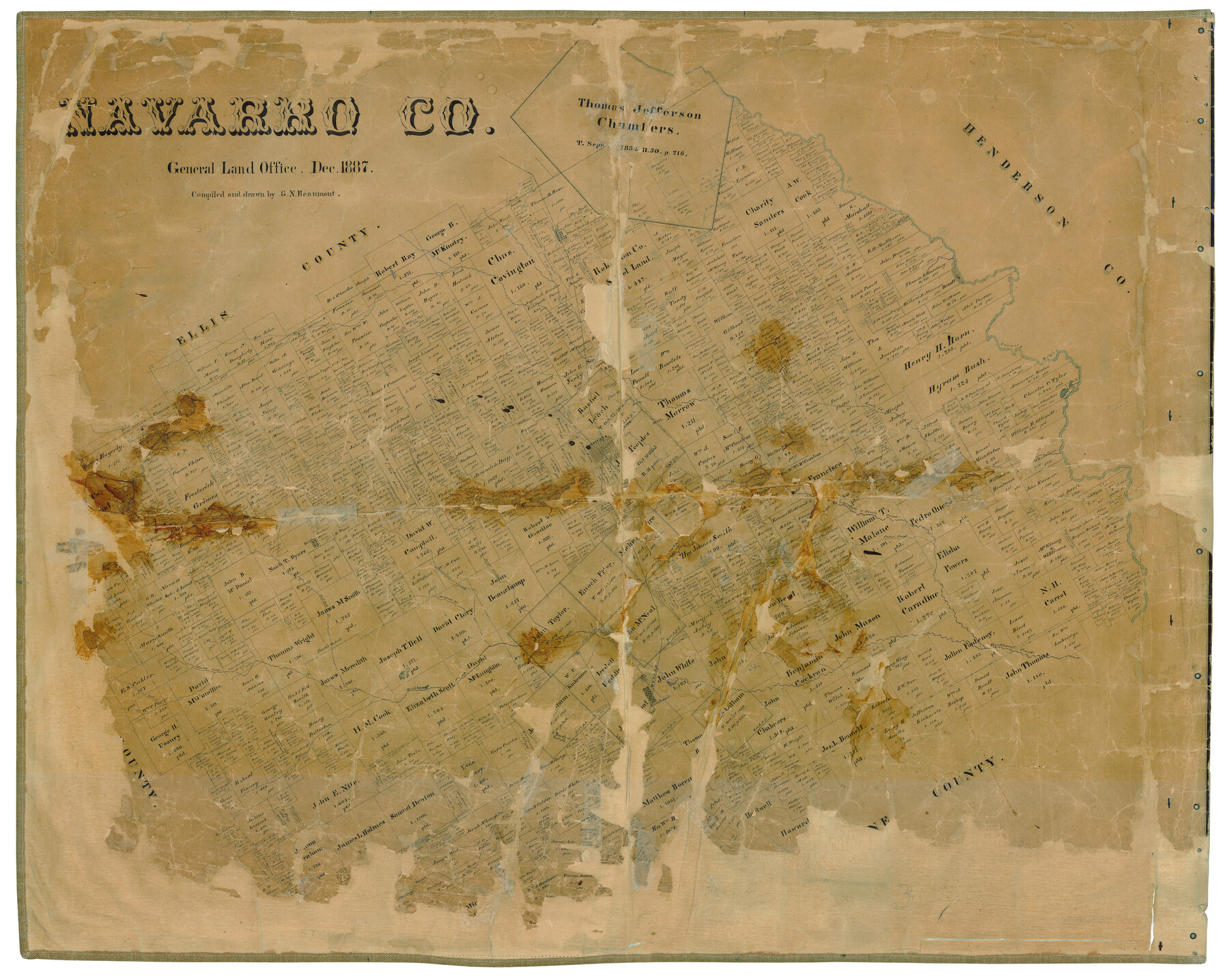
Navarro Co.
-
Map/Doc
16777
-
Collection
General Map Collection
-
Object Dates
12/1887 (Creation Date)
-
People and Organizations
G.N. Beaumont (Draftsman)
-
Counties
Navarro
-
Subjects
County
-
Height x Width
40.7 x 50.8 inches
103.4 x 129.0 cm
-
Comments
Help Save Texas History - Adopt Me!
-
Features
Melton Branch [of Cottonwood Creek]
Chambers Creek
Pecan Creek
Corsicana
Richland
Ash Creek
North Fork [of Richland Creek]
Rock Creek
Camp Creek
Briar Creek
Rice
Cottonwood Creek
Post Oak Creek
Bazett
Richland Creek
H&TC
Cedar Creek
Dresden
Rush Creek
Trinity River
Part of: General Map Collection
Polk County Working Sketch 35

Print $20.00
- Digital $50.00
Polk County Working Sketch 35
1961
Size 16.7 x 12.1 inches
Map/Doc 71652
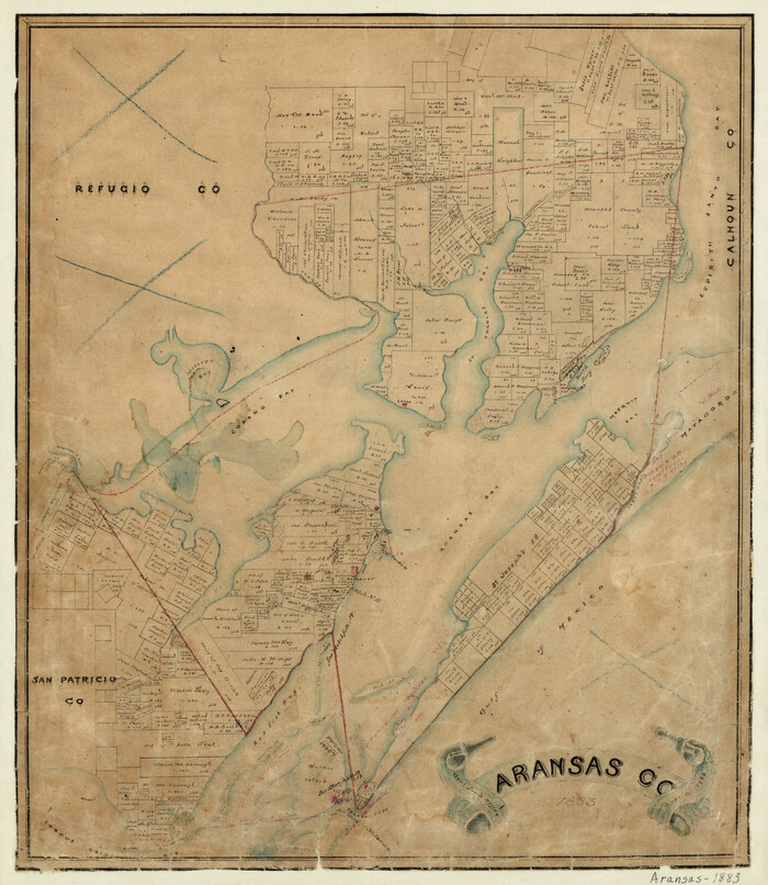
Aransas County
Print $20.00
- Digital $50.00
Aransas County
1883
Size 19.9 x 17.1 inches
Map/Doc 3236
Flight Mission No. DQN-1K, Frame 49, Calhoun County

Print $20.00
- Digital $50.00
Flight Mission No. DQN-1K, Frame 49, Calhoun County
1953
Size 18.6 x 22.4 inches
Map/Doc 84149
Upton County Sketch File 13

Print $20.00
- Digital $50.00
Upton County Sketch File 13
1926
Size 34.3 x 37.3 inches
Map/Doc 10414

Flight Mission No. CRC-3R, Frame 47, Chambers County

Print $20.00
- Digital $50.00
Flight Mission No. CRC-3R, Frame 47, Chambers County
1956
Size 18.6 x 22.3 inches
Map/Doc 84820
Pecos County Sketch File 41

Print $32.00
- Digital $50.00
Pecos County Sketch File 41
1919
Size 11.2 x 8.8 inches
Map/Doc 33729
Blanco County Boundary File 7

Print $58.00
- Digital $50.00
Blanco County Boundary File 7
Size 14.3 x 8.5 inches
Map/Doc 50565
Flight Mission No. DAG-14K, Frame 146, Matagorda County

Print $20.00
- Digital $50.00
Flight Mission No. DAG-14K, Frame 146, Matagorda County
1952
Size 18.4 x 22.2 inches
Map/Doc 86313
Flight Mission No. DQN-2K, Frame 99, Calhoun County

Print $20.00
- Digital $50.00
Flight Mission No. DQN-2K, Frame 99, Calhoun County
1953
Size 18.7 x 22.3 inches
Map/Doc 84289
East Part of Liberty Co.

Print $20.00
- Digital $50.00
East Part of Liberty Co.
1977
Size 46.1 x 35.9 inches
Map/Doc 73219
Young County Sketch File 19

Print $34.00
- Digital $50.00
Young County Sketch File 19
Size 14.5 x 8.9 inches
Map/Doc 40887
You may also like
Irion County Rolled Sketch 19

Print $20.00
- Digital $50.00
Irion County Rolled Sketch 19
Size 19.3 x 27.5 inches
Map/Doc 6328
Ward County Working Sketch 25

Print $40.00
- Digital $50.00
Ward County Working Sketch 25
1957
Size 74.3 x 25.6 inches
Map/Doc 72331
Crockett County Rolled Sketch 48

Print $20.00
- Digital $50.00
Crockett County Rolled Sketch 48
1939
Size 30.0 x 40.3 inches
Map/Doc 8712
Harris County Historic Topographic 23

Print $20.00
- Digital $50.00
Harris County Historic Topographic 23
1916
Size 29.2 x 22.6 inches
Map/Doc 65834
Hartley County Working Sketch 7

Print $20.00
- Digital $50.00
Hartley County Working Sketch 7
1971
Size 20.1 x 25.1 inches
Map/Doc 66057
[Sections 15, 16, 17, 18, Block B]
![92798, [Sections 15, 16, 17, 18, Block B], Twichell Survey Records](https://historictexasmaps.com/wmedia_w700/maps/92798-1.tif.jpg)
Print $20.00
- Digital $50.00
[Sections 15, 16, 17, 18, Block B]
Size 40.0 x 10.5 inches
Map/Doc 92798
Flight Mission No. BRA-6M, Frame 142, Jefferson County

Print $20.00
- Digital $50.00
Flight Mission No. BRA-6M, Frame 142, Jefferson County
1953
Size 18.6 x 22.3 inches
Map/Doc 85443
Val Verde County Rolled Sketch 27

Print $20.00
- Digital $50.00
Val Verde County Rolled Sketch 27
Size 26.0 x 37.9 inches
Map/Doc 8109
Flight Mission No. DQN-2K, Frame 8, Calhoun County

Print $20.00
- Digital $50.00
Flight Mission No. DQN-2K, Frame 8, Calhoun County
1953
Size 15.8 x 15.6 inches
Map/Doc 84225
Aransas Pass to Baffin Bay

Print $20.00
- Digital $50.00
Aransas Pass to Baffin Bay
1992
Size 45.0 x 36.0 inches
Map/Doc 73423
Jefferson County Sketch File 10

Print $32.00
- Digital $50.00
Jefferson County Sketch File 10
Size 8.0 x 6.8 inches
Map/Doc 28125
Zapata County Working Sketch Graphic Index, Sheet 1 (Sketches 1 to 18)

Print $40.00
- Digital $50.00
Zapata County Working Sketch Graphic Index, Sheet 1 (Sketches 1 to 18)
1935
Size 55.3 x 41.3 inches
Map/Doc 76749