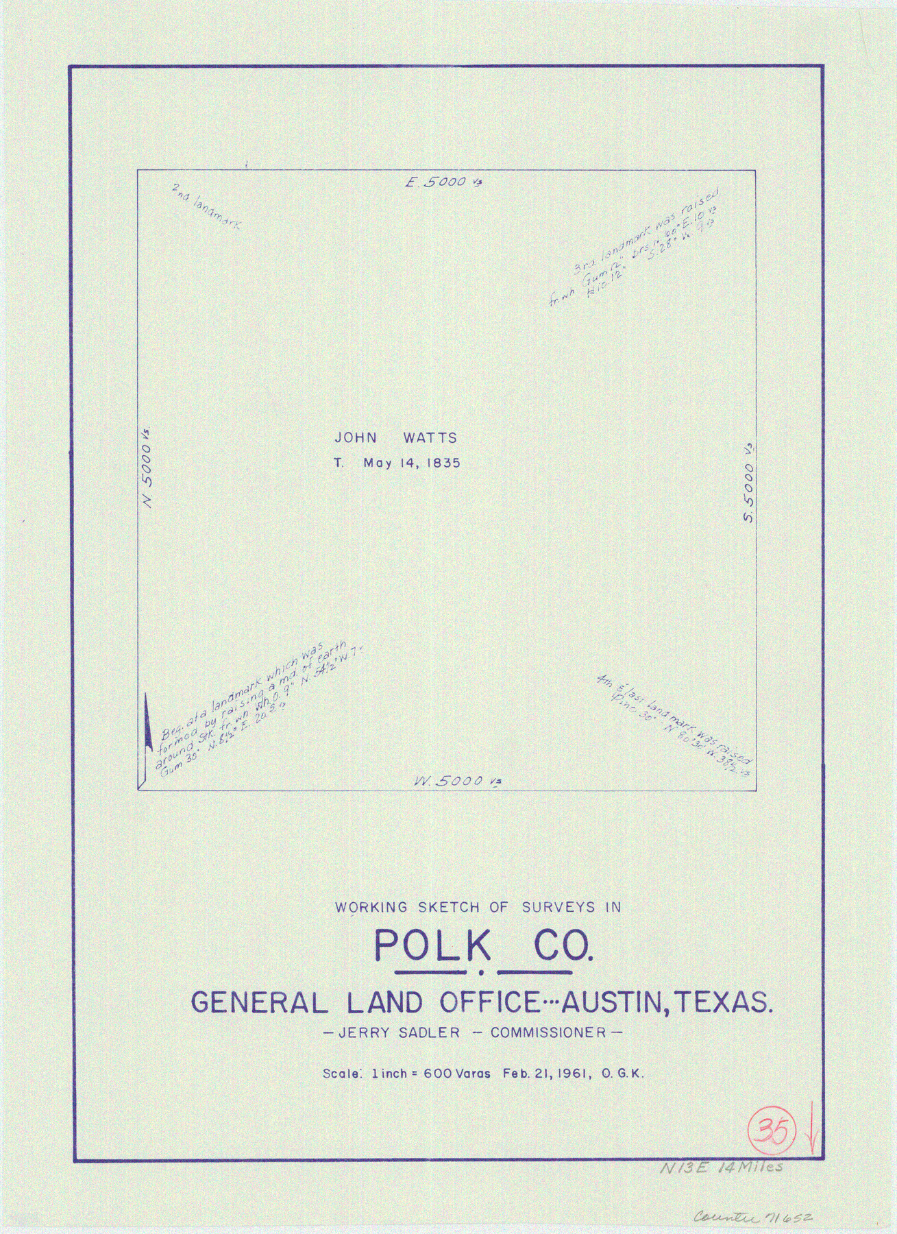
Polk County Working Sketch 35
-
Map/Doc
71652
-
Collection
General Map Collection
-
Object Dates
2/21/1961 (Creation Date)
-
People and Organizations
Otto G. Kurio (Draftsman)
-
Counties
Polk
-
Subjects
Surveying Working Sketch
-
Height x Width
16.7 x 12.1 inches
42.4 x 30.7 cm
-
Scale
1" = 600 varas
Part of: General Map Collection
Yoakum County Sketch File 10a

Print $44.00
- Digital $50.00
Yoakum County Sketch File 10a
1928
Size 48.5 x 33.7 inches
Map/Doc 10437
Polk County Rolled Sketch 31

Print $20.00
- Digital $50.00
Polk County Rolled Sketch 31
Size 24.5 x 21.1 inches
Map/Doc 7317
Childress County Sketch File 13

Print $12.00
- Digital $50.00
Childress County Sketch File 13
1896
Size 6.4 x 8.7 inches
Map/Doc 18266
Palo Pinto County Working Sketch 10

Print $20.00
- Digital $50.00
Palo Pinto County Working Sketch 10
Size 12.5 x 17.4 inches
Map/Doc 71393
Brewster County Sketch File NS-4g

Print $4.00
- Digital $50.00
Brewster County Sketch File NS-4g
1930
Size 10.5 x 7.2 inches
Map/Doc 15981
McMullen County Sketch File 24

Print $22.00
- Digital $50.00
McMullen County Sketch File 24
Size 8.7 x 12.6 inches
Map/Doc 31381
Brewster County Sketch File N-22

Print $40.00
- Digital $50.00
Brewster County Sketch File N-22
Size 12.4 x 21.4 inches
Map/Doc 10969
Flight Mission No. CGI-1N, Frame 218, Cameron County

Print $20.00
- Digital $50.00
Flight Mission No. CGI-1N, Frame 218, Cameron County
1955
Size 18.6 x 22.1 inches
Map/Doc 84527
Wise County Sketch File 22

Print $4.00
- Digital $50.00
Wise County Sketch File 22
1860
Size 7.5 x 7.2 inches
Map/Doc 40566
Terrell County

Print $20.00
- Digital $50.00
Terrell County
1905
Size 41.6 x 30.9 inches
Map/Doc 63061
Guadalupe County Rolled Sketch 1

Print $20.00
- Digital $50.00
Guadalupe County Rolled Sketch 1
1954
Size 33.1 x 38.8 inches
Map/Doc 6044
El Paso County Rolled Sketch 44

Print $129.00
- Digital $50.00
El Paso County Rolled Sketch 44
1902
Size 10.4 x 15.5 inches
Map/Doc 44430
You may also like
[Northeast 1/4 of County Map showing Durrell's Tie Line]
![91619, [Northeast 1/4 of County Map showing Durrell's Tie Line], Twichell Survey Records](https://historictexasmaps.com/wmedia_w700/maps/91619-1.tif.jpg)
Print $20.00
- Digital $50.00
[Northeast 1/4 of County Map showing Durrell's Tie Line]
Size 24.1 x 18.7 inches
Map/Doc 91619
Blanco County Sketch File 26

Print $40.00
- Digital $50.00
Blanco County Sketch File 26
1888
Size 14.1 x 17.2 inches
Map/Doc 14618
[Unknown Building Sketch]
![75793, [Unknown Building Sketch], Maddox Collection](https://historictexasmaps.com/wmedia_w700/maps/75793.tif.jpg)
Print $20.00
- Digital $50.00
[Unknown Building Sketch]
Size 15.3 x 23.0 inches
Map/Doc 75793
Map of Hopkins County

Print $20.00
- Digital $50.00
Map of Hopkins County
1872
Size 17.8 x 18.4 inches
Map/Doc 4566
Anderson County Working Sketch 12

Print $20.00
- Digital $50.00
Anderson County Working Sketch 12
1914
Size 15.1 x 12.4 inches
Map/Doc 67012
Martin County Rolled Sketch 4

Print $20.00
- Digital $50.00
Martin County Rolled Sketch 4
1908
Size 40.9 x 24.8 inches
Map/Doc 6665
Tarrant County Working Sketch 21

Print $20.00
- Digital $50.00
Tarrant County Working Sketch 21
1999
Size 17.4 x 22.8 inches
Map/Doc 62438
Dallas County Boundary File 6g

Print $6.00
- Digital $50.00
Dallas County Boundary File 6g
Size 11.2 x 8.7 inches
Map/Doc 52275
Culberson County Working Sketch 24

Print $20.00
- Digital $50.00
Culberson County Working Sketch 24
1947
Size 36.8 x 36.2 inches
Map/Doc 68477
Flight Mission No. DQN-6K, Frame 10, Calhoun County

Print $20.00
- Digital $50.00
Flight Mission No. DQN-6K, Frame 10, Calhoun County
1953
Size 18.5 x 22.3 inches
Map/Doc 84432
Aransas County Rolled Sketch 19C

Print $20.00
- Digital $50.00
Aransas County Rolled Sketch 19C
Size 40.9 x 30.6 inches
Map/Doc 5063
Navigation Maps of Gulf Intracoastal Waterway, Port Arthur to Brownsville, Texas

Print $4.00
- Digital $50.00
Navigation Maps of Gulf Intracoastal Waterway, Port Arthur to Brownsville, Texas
1951
Size 16.6 x 21.3 inches
Map/Doc 65438