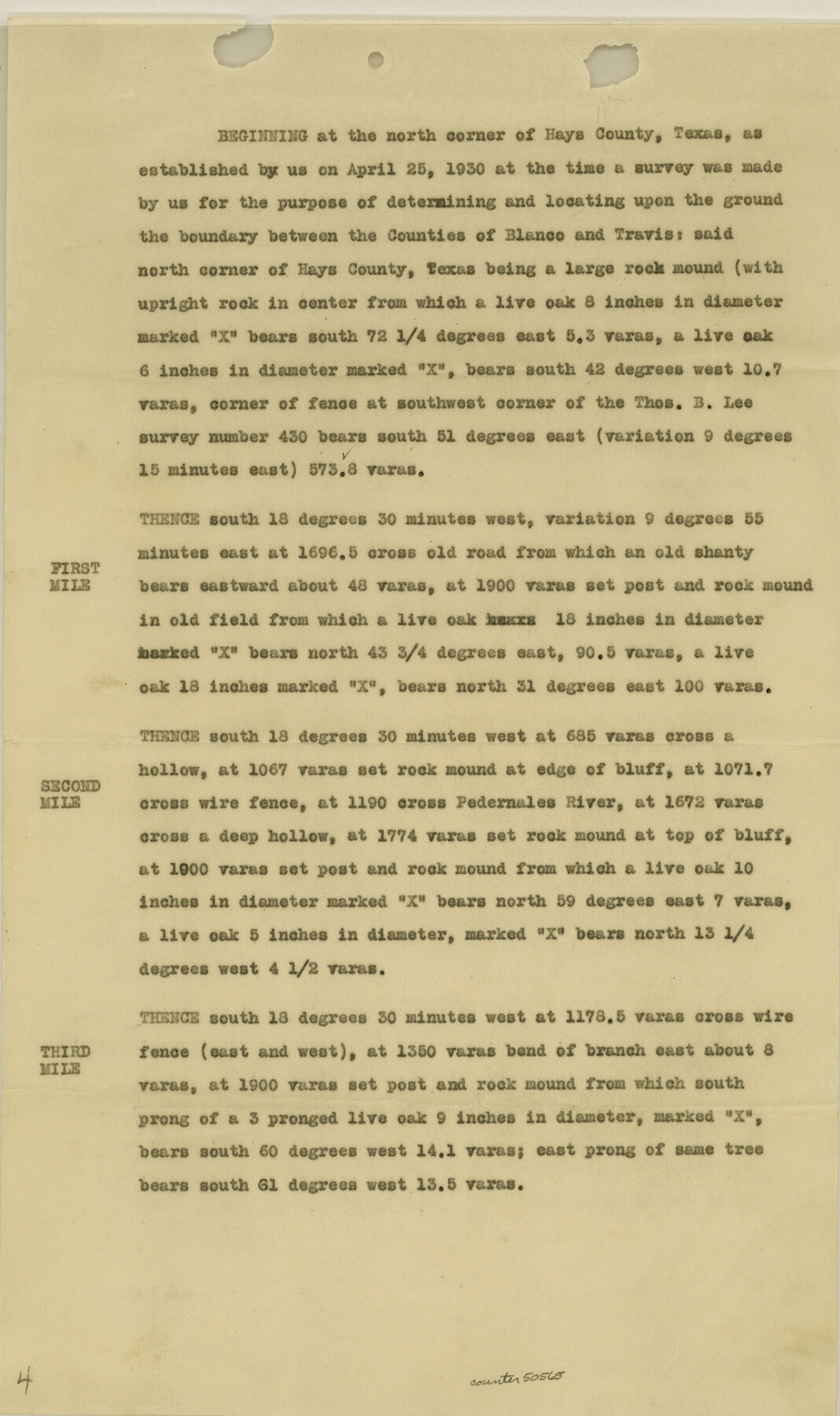
Blanco County Boundary File 7
Field Notes Blanco-Hays County Line
-
Map/Doc
50565
-
Collection
General Map Collection
-
Counties
Blanco
-
Subjects
County Boundaries
-
Height x Width
14.3 x 8.5 inches
36.3 x 21.6 cm
Part of: General Map Collection
No. 2 Chart of Corpus Christi Pass, Texas

Print $20.00
- Digital $50.00
No. 2 Chart of Corpus Christi Pass, Texas
1878
Size 18.3 x 27.3 inches
Map/Doc 73014
Gulf, Texas & Western Railway

Print $40.00
- Digital $50.00
Gulf, Texas & Western Railway
1909
Size 18.7 x 103.5 inches
Map/Doc 64431
El Paso County Working Sketch 46

Print $20.00
- Digital $50.00
El Paso County Working Sketch 46
1987
Size 38.3 x 37.5 inches
Map/Doc 69068
Wichita County Sketch File 24

Print $20.00
- Digital $50.00
Wichita County Sketch File 24
1919
Size 17.3 x 24.0 inches
Map/Doc 12684
Pecos County Working Sketch 8

Print $20.00
- Digital $50.00
Pecos County Working Sketch 8
1906
Size 15.4 x 14.8 inches
Map/Doc 71478
Brewster County Rolled Sketch 59D

Print $20.00
- Digital $50.00
Brewster County Rolled Sketch 59D
Size 33.3 x 47.3 inches
Map/Doc 5231
Galveston County NRC Article 33.136 Sketch 59

Print $24.00
- Digital $50.00
Galveston County NRC Article 33.136 Sketch 59
2008
Size 11.5 x 17.0 inches
Map/Doc 94606
McCulloch County Sketch File 8

Print $4.00
- Digital $50.00
McCulloch County Sketch File 8
1904
Size 11.3 x 8.7 inches
Map/Doc 31182

Wichita County Rolled Sketch 18

Print $20.00
- Digital $50.00
Wichita County Rolled Sketch 18
1923
Size 25.7 x 38.0 inches
Map/Doc 8254
Flight Mission No. CRC-4R, Frame 113, Chambers County

Print $20.00
- Digital $50.00
Flight Mission No. CRC-4R, Frame 113, Chambers County
1956
Size 18.6 x 22.3 inches
Map/Doc 84910
Comal County Sketch File 9 1/2

Print $6.00
- Digital $50.00
Comal County Sketch File 9 1/2
Size 12.9 x 8.4 inches
Map/Doc 19018
You may also like
Flight Mission No. CRK-5P, Frame 155, Refugio County

Print $20.00
- Digital $50.00
Flight Mission No. CRK-5P, Frame 155, Refugio County
1956
Size 18.7 x 22.6 inches
Map/Doc 86936
Sabine County Sketch File 5

Print $8.00
Sabine County Sketch File 5
1876
Size 12.9 x 8.5 inches
Map/Doc 35608
Sketch of Surveys on Peach Point, J. Perry's Property

Print $20.00
- Digital $50.00
Sketch of Surveys on Peach Point, J. Perry's Property
1832
Size 14.0 x 20.6 inches
Map/Doc 219
R. S. Coon's Blue Creek Ranch, Moore County, Texas

Print $20.00
- Digital $50.00
R. S. Coon's Blue Creek Ranch, Moore County, Texas
Size 15.8 x 15.7 inches
Map/Doc 91487
Culberson Co.

Print $40.00
- Digital $50.00
Culberson Co.
1943
Size 52.2 x 33.2 inches
Map/Doc 73124
[Blks. Z, C4, 194, 178, C3, A2, 179 and 207]
![89837, [Blks. Z, C4, 194, 178, C3, A2, 179 and 207], Twichell Survey Records](https://historictexasmaps.com/wmedia_w700/maps/89837-1.tif.jpg)
Print $40.00
- Digital $50.00
[Blks. Z, C4, 194, 178, C3, A2, 179 and 207]
Size 61.6 x 37.5 inches
Map/Doc 89837
Mason County Sketch File 5

Print $20.00
- Digital $50.00
Mason County Sketch File 5
1875
Size 15.8 x 12.9 inches
Map/Doc 12033
[Castro, Lamb, Hockley, Swisher, Hale, and Lubbock Counties]
![91026, [Castro, Lamb, Hockley, Swisher, Hale, and Lubbock Counties], Twichell Survey Records](https://historictexasmaps.com/wmedia_w700/maps/91026-1.tif.jpg)
Print $20.00
- Digital $50.00
[Castro, Lamb, Hockley, Swisher, Hale, and Lubbock Counties]
Size 28.7 x 37.6 inches
Map/Doc 91026
Brazoria County Sketch File 2

Print $6.00
- Digital $50.00
Brazoria County Sketch File 2
Size 8.0 x 3.3 inches
Map/Doc 14920
Wichita County Sketch File 29

Print $9.00
- Digital $50.00
Wichita County Sketch File 29
1930
Size 11.3 x 8.8 inches
Map/Doc 40132
Flight Mission No. DAG-23K, Frame 58, Matagorda County

Print $20.00
- Digital $50.00
Flight Mission No. DAG-23K, Frame 58, Matagorda County
1953
Size 18.4 x 22.3 inches
Map/Doc 86485
Duval County Working Sketch 20

Print $20.00
- Digital $50.00
Duval County Working Sketch 20
1940
Size 20.5 x 12.7 inches
Map/Doc 68733