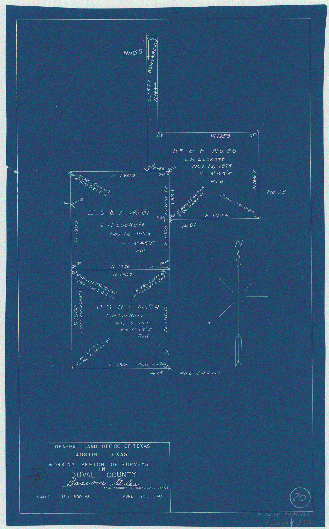
Duval County Working Sketch 20
-
Map/Doc
68733
-
Collection
General Map Collection
-
Object Dates
6/25/1940 (Creation Date)
-
Counties
Duval
-
Subjects
Surveying Working Sketch
-
Height x Width
20.5 x 12.7 inches
52.1 x 32.3 cm
-
Scale
1" = 500 varas
Part of: General Map Collection
Sutton County Sketch File 41

Print $4.00
- Digital $50.00
Sutton County Sketch File 41
1940
Size 14.4 x 8.6 inches
Map/Doc 37507
Leon County Working Sketch 24

Print $20.00
- Digital $50.00
Leon County Working Sketch 24
1967
Size 23.3 x 29.0 inches
Map/Doc 70423
Pecos County Rolled Sketch 179

Print $20.00
- Digital $50.00
Pecos County Rolled Sketch 179
1980
Size 28.0 x 28.2 inches
Map/Doc 7299
Coke County Working Sketch 30

Print $20.00
- Digital $50.00
Coke County Working Sketch 30
1982
Size 15.7 x 22.4 inches
Map/Doc 76064
Concho County Sketch File 52

Print $4.00
- Digital $50.00
Concho County Sketch File 52
1953
Size 14.5 x 8.9 inches
Map/Doc 19220
Duval County Sketch File 78

Print $2.00
- Digital $50.00
Duval County Sketch File 78
1984
Size 14.5 x 8.9 inches
Map/Doc 21468
Gregg County Rolled Sketch 16A

Print $20.00
- Digital $50.00
Gregg County Rolled Sketch 16A
1942
Size 30.1 x 40.4 inches
Map/Doc 6039
A New Map, or Chart in Mercators Projection, of the Western or Atlantic Ocean, with part of Europe, Africa and America

Print $20.00
- Digital $50.00
A New Map, or Chart in Mercators Projection, of the Western or Atlantic Ocean, with part of Europe, Africa and America
1781
Size 17.3 x 21.7 inches
Map/Doc 95368
Real County Working Sketch 6

Print $20.00
- Digital $50.00
Real County Working Sketch 6
1924
Size 21.2 x 9.3 inches
Map/Doc 71898
Anderson County Working Sketch 39

Print $20.00
- Digital $50.00
Anderson County Working Sketch 39
1986
Size 21.6 x 21.8 inches
Map/Doc 67039
Ochiltree County

Print $20.00
- Digital $50.00
Ochiltree County
1958
Size 44.4 x 35.5 inches
Map/Doc 95603
Parker County Working Sketch 18

Print $20.00
- Digital $50.00
Parker County Working Sketch 18
2000
Map/Doc 71468
You may also like
Callahan County Sketch File 14

Print $40.00
- Digital $50.00
Callahan County Sketch File 14
1938
Size 20.5 x 26.1 inches
Map/Doc 11042
Caldwell County Working Sketch 12

Print $20.00
- Digital $50.00
Caldwell County Working Sketch 12
1979
Size 47.7 x 44.2 inches
Map/Doc 67842
Copy of Surveyor's Field Book, Morris Browning - In Blocks 7, 5 & 4, I&GNRRCo., Hutchinson and Carson Counties, Texas

Print $2.00
- Digital $50.00
Copy of Surveyor's Field Book, Morris Browning - In Blocks 7, 5 & 4, I&GNRRCo., Hutchinson and Carson Counties, Texas
1888
Size 7.0 x 8.9 inches
Map/Doc 62268
Atascosa County Sketch File 12

Print $4.00
- Digital $50.00
Atascosa County Sketch File 12
1862
Size 14.4 x 8.3 inches
Map/Doc 13769
A General Map of the Southern British Colonies, in America. comprehending North and South Carolina, Georgia, East and West Florida, with the Neighbouring Indian Countries

Print $20.00
- Digital $50.00
A General Map of the Southern British Colonies, in America. comprehending North and South Carolina, Georgia, East and West Florida, with the Neighbouring Indian Countries
1776
Size 21.3 x 26.4 inches
Map/Doc 97403
Polk County Sketch File 18

Print $20.00
- Digital $50.00
Polk County Sketch File 18
1862
Size 25.5 x 18.9 inches
Map/Doc 12190
America's Fun-Tier: Texas 1967 Official State Highway Map

Digital $50.00
America's Fun-Tier: Texas 1967 Official State Highway Map
Size 28.3 x 36.6 inches
Map/Doc 94322
Haskell County

Print $20.00
- Digital $50.00
Haskell County
1933
Size 46.4 x 39.3 inches
Map/Doc 95525
Jefferson County NRC Article 33.136 Location Key Sheet

Print $20.00
- Digital $50.00
Jefferson County NRC Article 33.136 Location Key Sheet
1993
Size 27.0 x 21.8 inches
Map/Doc 77030
Zavalla [sic] County
![16938, Zavalla [sic] County, General Map Collection](https://historictexasmaps.com/wmedia_w700/maps/16938-1.tif.jpg)
Print $20.00
- Digital $50.00
Zavalla [sic] County
1894
Size 42.3 x 44.6 inches
Map/Doc 16938
Presidio County Sketch File 84

Print $20.00
- Digital $50.00
Presidio County Sketch File 84
1949
Size 15.2 x 37.2 inches
Map/Doc 11723
Terrell County Rolled Sketch 48

Print $20.00
- Digital $50.00
Terrell County Rolled Sketch 48
1959
Size 20.5 x 22.3 inches
Map/Doc 7950