Wichita County Sketch File 29
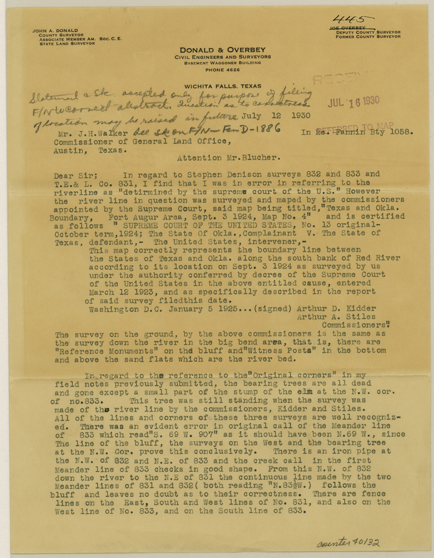
[Sketch and explanation as to the location of the S. Denison surveys 832 and 833 and the T. E. & L. survey 831 on the south bank of the Red River]
-
Map/Doc
40132
-
Collection
General Map Collection
-
Object Dates
7/12/1930 (Creation Date)
7/16/1930 (File Date)
-
People and Organizations
Joe Overbey (Surveyor/Engineer)
-
Counties
Wichita
-
Subjects
Surveying Sketch File
-
Height x Width
11.3 x 8.8 inches
28.7 x 22.4 cm
-
Medium
blueprint/diazo
Part of: General Map Collection
Chambers County Working Sketch 12

Print $20.00
- Digital $50.00
Chambers County Working Sketch 12
1954
Size 35.2 x 33.8 inches
Map/Doc 67995
Red River County Working Sketch 23

Print $20.00
- Digital $50.00
Red River County Working Sketch 23
1958
Size 30.7 x 26.1 inches
Map/Doc 72006
Orange County Working Sketch 44

Print $20.00
- Digital $50.00
Orange County Working Sketch 44
1980
Size 16.5 x 22.0 inches
Map/Doc 71376
Ward County Rolled Sketch 24F

Print $40.00
- Digital $50.00
Ward County Rolled Sketch 24F
1967
Size 43.0 x 72.4 inches
Map/Doc 10117
Knox County Boundary File 2

Print $40.00
- Digital $50.00
Knox County Boundary File 2
Size 31.1 x 34.1 inches
Map/Doc 65017
Lamar County Working Sketch 3

Print $20.00
- Digital $50.00
Lamar County Working Sketch 3
1919
Size 26.2 x 24.5 inches
Map/Doc 70264
Limestone County Sketch File 8

Print $20.00
- Digital $50.00
Limestone County Sketch File 8
1869
Size 15.6 x 23.7 inches
Map/Doc 12002
Travis County Appraisal District Plat Map 2_1004

Print $20.00
- Digital $50.00
Travis County Appraisal District Plat Map 2_1004
Size 21.4 x 26.5 inches
Map/Doc 94238
Flight Mission No. DCL-5C, Frame 69, Kenedy County

Print $20.00
- Digital $50.00
Flight Mission No. DCL-5C, Frame 69, Kenedy County
1943
Size 18.5 x 22.3 inches
Map/Doc 85852

Intracoastal Waterway in Texas - Corpus Christi to Point Isabel including Arroyo Colorado to Mo. Pac. R.R. Bridge Near Harlingen

Print $20.00
- Digital $50.00
Intracoastal Waterway in Texas - Corpus Christi to Point Isabel including Arroyo Colorado to Mo. Pac. R.R. Bridge Near Harlingen
1934
Size 22.0 x 32.7 inches
Map/Doc 61884
Hemphill County Working Sketch 36

Print $40.00
- Digital $50.00
Hemphill County Working Sketch 36
1978
Size 38.3 x 51.7 inches
Map/Doc 66131
You may also like
Hartley County Sketch File 9

Print $12.00
- Digital $50.00
Hartley County Sketch File 9
1903
Size 10.8 x 7.2 inches
Map/Doc 26094
Eastland County Working Sketch 58

Print $20.00
- Digital $50.00
Eastland County Working Sketch 58
1985
Size 25.5 x 39.6 inches
Map/Doc 68839
Index for Texas Railroad ROW & track maps available on microfilm at THD & Archives and Records

Print $2.00
- Digital $50.00
Index for Texas Railroad ROW & track maps available on microfilm at THD & Archives and Records
1977
Size 11.1 x 8.7 inches
Map/Doc 60762
Bexar County Working Sketch 2

Print $20.00
- Digital $50.00
Bexar County Working Sketch 2
1940
Size 24.8 x 27.9 inches
Map/Doc 67318
Crockett County Sketch File F

Print $20.00
- Digital $50.00
Crockett County Sketch File F
1907
Size 26.3 x 15.7 inches
Map/Doc 11240
Survey in South Austin for Mr. R.N. Graham

Print $20.00
- Digital $50.00
Survey in South Austin for Mr. R.N. Graham
1915
Size 22.6 x 33.8 inches
Map/Doc 564
Culberson County Rolled Sketch 52

Print $20.00
- Digital $50.00
Culberson County Rolled Sketch 52
Size 19.1 x 24.7 inches
Map/Doc 5672
Navarro County Working Sketch Graphic Index

Print $40.00
- Digital $50.00
Navarro County Working Sketch Graphic Index
1924
Size 42.7 x 48.7 inches
Map/Doc 76652
San Patricio County Rolled Sketch 46B

Print $3.00
- Digital $50.00
San Patricio County Rolled Sketch 46B
1983
Size 12.5 x 10.0 inches
Map/Doc 8373
San Patricio County Sketch File 48

Print $88.00
- Digital $50.00
San Patricio County Sketch File 48
Size 9.0 x 9.0 inches
Map/Doc 36285
Montague County Sketch File 7

Print $6.00
- Digital $50.00
Montague County Sketch File 7
1860
Size 6.3 x 5.4 inches
Map/Doc 31719
Die gantze Welt in ein Kleberblat, welches in der Stadt Hannover, meines lieben Vaterlandes Wapen

Print $20.00
- Digital $50.00
Die gantze Welt in ein Kleberblat, welches in der Stadt Hannover, meines lieben Vaterlandes Wapen
1581
Size 11.9 x 15.2 inches
Map/Doc 97240