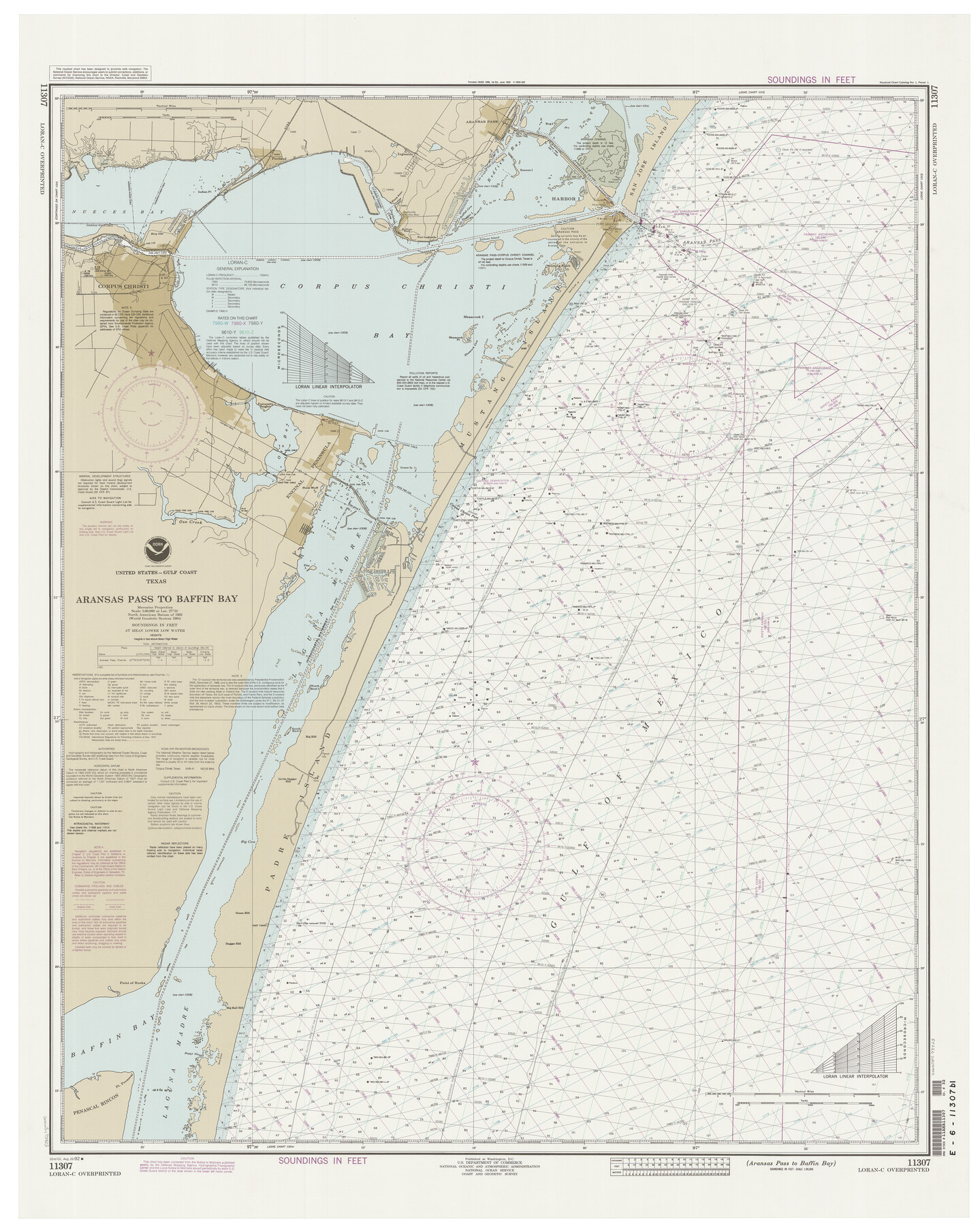
Aransas Pass to Baffin Bay
-
Map/Doc
73423
-
Collection
General Map Collection
-
Object Dates
8/22/1992 (Creation Date)
-
Counties
Aransas San Patricio Nueces Kleberg Kenedy
-
Subjects
Nautical Charts
-
Height x Width
45.0 x 36.0 inches
114.3 x 91.4 cm
Part of: General Map Collection
McMullen County Sketch File 35

Print $10.00
- Digital $50.00
McMullen County Sketch File 35
Size 9.7 x 8.5 inches
Map/Doc 31402
Loving County Working Sketch 3

Print $20.00
- Digital $50.00
Loving County Working Sketch 3
1941
Size 18.0 x 42.2 inches
Map/Doc 70635
La Salle County Working Sketch 22

Print $20.00
- Digital $50.00
La Salle County Working Sketch 22
1942
Size 36.2 x 29.2 inches
Map/Doc 70323
Flight Mission No. CON-2R, Frame 173, Stonewall County

Print $20.00
- Digital $50.00
Flight Mission No. CON-2R, Frame 173, Stonewall County
1957
Size 18.3 x 22.1 inches
Map/Doc 86991
Red River County Working Sketch 10

Print $20.00
- Digital $50.00
Red River County Working Sketch 10
1920
Size 19.1 x 18.8 inches
Map/Doc 71993

Zavala County Working Sketch Graphic Index

Print $20.00
- Digital $50.00
Zavala County Working Sketch Graphic Index
1977
Size 42.2 x 48.2 inches
Map/Doc 76751
Harris County Historic Topographic 21

Print $20.00
- Digital $50.00
Harris County Historic Topographic 21
1915
Size 29.2 x 22.5 inches
Map/Doc 65832
Williamson County

Print $40.00
- Digital $50.00
Williamson County
1946
Size 40.1 x 57.7 inches
Map/Doc 63130
Aransas County Sketch File 29

Print $24.00
- Digital $50.00
Aransas County Sketch File 29
Size 7.8 x 8.1 inches
Map/Doc 13234
Edwards County Sketch File 9

Print $20.00
- Digital $50.00
Edwards County Sketch File 9
Size 16.9 x 37.8 inches
Map/Doc 10443
Origin of Imports and Destination of Exports at Galveston, Tex., during 1921

Print $20.00
- Digital $50.00
Origin of Imports and Destination of Exports at Galveston, Tex., during 1921
1921
Size 13.1 x 24.6 inches
Map/Doc 97169
You may also like
Flight Mission No. CLL-1N, Frame 36, Willacy County

Print $20.00
- Digital $50.00
Flight Mission No. CLL-1N, Frame 36, Willacy County
1954
Size 18.3 x 22.1 inches
Map/Doc 87017
Limestone Co.

Print $40.00
- Digital $50.00
Limestone Co.
1971
Size 49.9 x 34.5 inches
Map/Doc 95571
Capitol Land Reservation

Print $20.00
- Digital $50.00
Capitol Land Reservation
1880
Size 27.1 x 34.4 inches
Map/Doc 10746
Hill County Sketch File 24

Print $40.00
- Digital $50.00
Hill County Sketch File 24
Size 15.6 x 13.8 inches
Map/Doc 26516
G. C. & S. F. Ry., San Saba Branch, Texas, Right of Way Map, Hall to Brady

Print $20.00
- Digital $50.00
G. C. & S. F. Ry., San Saba Branch, Texas, Right of Way Map, Hall to Brady
1916
Size 36.9 x 34.0 inches
Map/Doc 61419
Newton County Sketch File 42

Print $39.00
- Digital $50.00
Newton County Sketch File 42
1936
Size 13.2 x 8.7 inches
Map/Doc 32425
Working Sketch in Armstrong County

Print $20.00
- Digital $50.00
Working Sketch in Armstrong County
1918
Size 31.5 x 24.3 inches
Map/Doc 90265
Nueces County Rolled Sketch 128 A-E

Print $10.00
- Digital $50.00
Nueces County Rolled Sketch 128 A-E
1998
Size 11.0 x 8.5 inches
Map/Doc 41611
Starr County Working Sketch 22

Print $20.00
- Digital $50.00
Starr County Working Sketch 22
1983
Size 25.8 x 33.1 inches
Map/Doc 63938
United States - Gulf Coast - Padre I. and Laguna Madre Lat. 27° 12' to Lat. 26° 33' Texas

Print $20.00
- Digital $50.00
United States - Gulf Coast - Padre I. and Laguna Madre Lat. 27° 12' to Lat. 26° 33' Texas
1913
Size 27.0 x 18.2 inches
Map/Doc 72813
Flight Mission No. DQN-7K, Frame 33, Calhoun County

Print $20.00
- Digital $50.00
Flight Mission No. DQN-7K, Frame 33, Calhoun County
1953
Size 18.5 x 22.1 inches
Map/Doc 84471
McMullen County Sketch File 31

Print $20.00
- Digital $50.00
McMullen County Sketch File 31
Size 44.7 x 15.6 inches
Map/Doc 10541