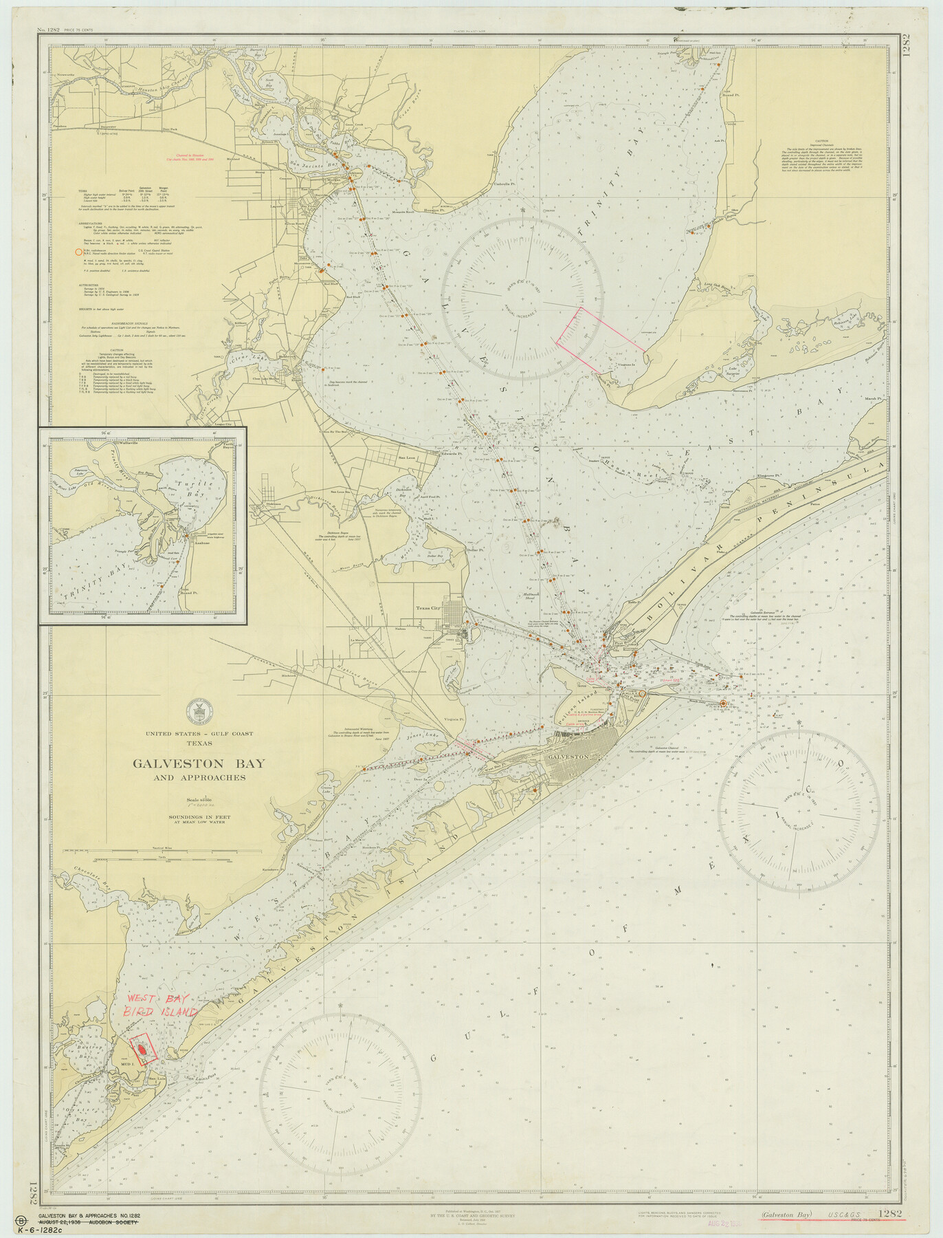
Galveston Bay and Approaches
K-6-1282d
-
Map/Doc
69875
-
Collection
General Map Collection
-
Object Dates
1938 (Creation Date)
-
Counties
Galveston Brazoria Chambers Harris
-
Subjects
Nautical Charts
-
Height x Width
45.4 x 34.6 inches
115.3 x 87.9 cm
Part of: General Map Collection
Wheeler County

Print $20.00
- Digital $50.00
Wheeler County
1932
Size 39.5 x 35.0 inches
Map/Doc 77456
Irion County Working Sketch 1

Print $20.00
- Digital $50.00
Irion County Working Sketch 1
Size 24.3 x 26.8 inches
Map/Doc 66410
Topographical Map of the Rio Grande, Sheet No. 23

Print $20.00
- Digital $50.00
Topographical Map of the Rio Grande, Sheet No. 23
1912
Map/Doc 89547
Map of Liberty County Texas

Print $20.00
- Digital $50.00
Map of Liberty County Texas
1879
Size 24.2 x 23.9 inches
Map/Doc 3814
Montague County Rolled Sketch 8

Print $20.00
- Digital $50.00
Montague County Rolled Sketch 8
Size 25.4 x 21.8 inches
Map/Doc 6792
Limestone County Rolled Sketch 3

Print $20.00
- Digital $50.00
Limestone County Rolled Sketch 3
Size 24.3 x 23.6 inches
Map/Doc 6627
Calhoun County NRC Article 33.136 Sketch 10

Digital $50.00
Calhoun County NRC Article 33.136 Sketch 10
2023
Map/Doc 97254
Kent County Rolled Sketch 7

Print $40.00
- Digital $50.00
Kent County Rolled Sketch 7
1954
Size 51.8 x 42.6 inches
Map/Doc 10221
Fannin County Working Sketch 4

Print $20.00
- Digital $50.00
Fannin County Working Sketch 4
1925
Size 24.6 x 31.4 inches
Map/Doc 69158
Glasscock County Sketch File 11

Print $6.00
- Digital $50.00
Glasscock County Sketch File 11
1933
Size 15.7 x 11.4 inches
Map/Doc 24174
Map of Great Britain and Ireland engraved to illustrate Mitchell's school and family geography

Print $20.00
- Digital $50.00
Map of Great Britain and Ireland engraved to illustrate Mitchell's school and family geography
1840
Size 11.8 x 9.5 inches
Map/Doc 93503
Calhoun County Boundary File 3

Print $8.00
- Digital $50.00
Calhoun County Boundary File 3
Size 11.3 x 8.7 inches
Map/Doc 50975
You may also like
Edwards County Sketch File 4

Print $5.00
- Digital $50.00
Edwards County Sketch File 4
Size 9.5 x 11.0 inches
Map/Doc 21680
Map of Collingsworth County

Print $20.00
- Digital $50.00
Map of Collingsworth County
1899
Size 41.1 x 38.6 inches
Map/Doc 4738
[Preliminary Drawing of School Leagues]
![89932, [Preliminary Drawing of School Leagues], Twichell Survey Records](https://historictexasmaps.com/wmedia_w700/maps/89932-1.tif.jpg)
Print $40.00
- Digital $50.00
[Preliminary Drawing of School Leagues]
Size 38.3 x 66.8 inches
Map/Doc 89932
Pecos County Sketch File 70

Print $20.00
- Digital $50.00
Pecos County Sketch File 70
1939
Size 21.3 x 20.7 inches
Map/Doc 12181
Potter County Rolled Sketch 10A

Print $40.00
- Digital $50.00
Potter County Rolled Sketch 10A
1920
Size 43.8 x 50.4 inches
Map/Doc 9760
Chambers County Sketch File 19

Print $26.00
- Digital $50.00
Chambers County Sketch File 19
Size 14.1 x 8.6 inches
Map/Doc 17578
Map of Duval County, Texas

Print $20.00
- Digital $50.00
Map of Duval County, Texas
1880
Size 31.4 x 21.8 inches
Map/Doc 5030
Fayette County Sketch File 5

Print $4.00
- Digital $50.00
Fayette County Sketch File 5
Size 14.3 x 8.7 inches
Map/Doc 22506
Wheeler County Working Sketch 17

Print $20.00
- Digital $50.00
Wheeler County Working Sketch 17
1982
Size 33.5 x 27.7 inches
Map/Doc 72506
Johnson County Working Sketch 31

Print $20.00
- Digital $50.00
Johnson County Working Sketch 31
2007
Size 21.2 x 22.0 inches
Map/Doc 87499
Galveston County Rolled Sketch 37

Print $20.00
- Digital $50.00
Galveston County Rolled Sketch 37
Size 26.8 x 16.5 inches
Map/Doc 5971
Nueces County Rolled Sketch 45

Print $20.00
- Digital $50.00
Nueces County Rolled Sketch 45
1941
Size 41.0 x 40.9 inches
Map/Doc 10203