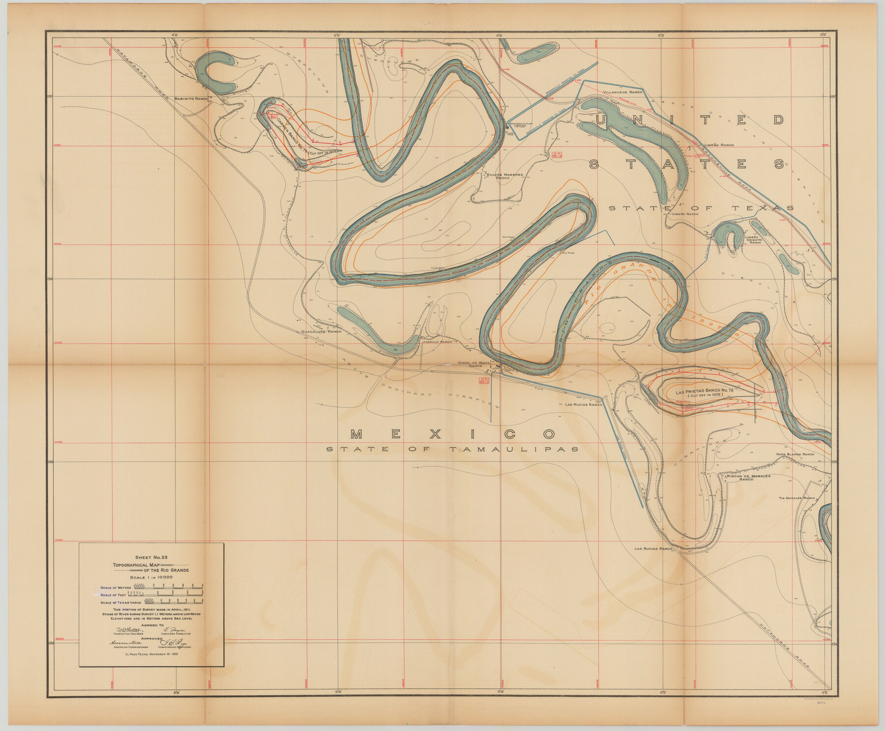
Topographical Map of the Rio Grande, Sheet No. 23
[from book: "Survey of the Rio Grande, Roma to the Gulf of Mexico, Reports and Maps"]
-
Map/Doc
89547
-
Collection
General Map Collection
-
Object Dates
1912/11/16 (Creation Date)
-
People and Organizations
International Boundary Commission (Publisher)
Anson Mills (Author)
E. Zayas (Surveyor/Engineer)
F.B. Puga (Author)
W.W. Follett (Surveyor/Engineer)
-
Subjects
River Surveys Texas Boundaries Topographic
-
Medium
paper
-
Scale
1:10000
-
Comments
This portion of the survey made in April, 1911. State of river during survey 1.1 meters above low water. Elevations are in meters above sea level. This map and 31 others were originally folded and bound into a book titled "Survey of the Rio Grande, R
Part of: General Map Collection
Martin County Sketch File 4

Print $20.00
- Digital $50.00
Martin County Sketch File 4
Size 26.9 x 19.8 inches
Map/Doc 12027
Mason County Working Sketch 15

Print $40.00
- Digital $50.00
Mason County Working Sketch 15
1976
Size 61.9 x 45.4 inches
Map/Doc 70851
Gaines County Rolled Sketch 14

Print $40.00
- Digital $50.00
Gaines County Rolled Sketch 14
Size 23.8 x 325.9 inches
Map/Doc 9030
Flight Mission No. DQN-1K, Frame 130, Calhoun County

Print $20.00
- Digital $50.00
Flight Mission No. DQN-1K, Frame 130, Calhoun County
1953
Size 18.5 x 22.1 inches
Map/Doc 84193
Brazoria County Rolled Sketch 32

Print $20.00
- Digital $50.00
Brazoria County Rolled Sketch 32
Size 29.1 x 22.6 inches
Map/Doc 5170
Outer Continental Shelf Leasing Maps (Louisiana Offshore Operations)

Print $20.00
- Digital $50.00
Outer Continental Shelf Leasing Maps (Louisiana Offshore Operations)
1959
Size 18.1 x 14.3 inches
Map/Doc 76110
Presidio County Sketch File 57

Print $8.00
- Digital $50.00
Presidio County Sketch File 57
1938
Size 14.3 x 8.9 inches
Map/Doc 34624
Harris County Rolled Sketch 88

Print $20.00
- Digital $50.00
Harris County Rolled Sketch 88
1934
Size 35.2 x 23.2 inches
Map/Doc 6120
Pecos County Rolled Sketch 104

Print $40.00
- Digital $50.00
Pecos County Rolled Sketch 104
Size 42.5 x 54.8 inches
Map/Doc 78197

Nueces County NRC Article 33.136 Sketch 20

Print $36.00
- Digital $50.00
Nueces County NRC Article 33.136 Sketch 20
2021
Map/Doc 96887
Trinity River, Levee Improvement Districts, Widths of Floodways

Print $4.00
- Digital $50.00
Trinity River, Levee Improvement Districts, Widths of Floodways
1919
Size 23.5 x 17.6 inches
Map/Doc 65250
You may also like
Rand McNally New Official Railroad Map of the United States and Southern Canada

Print $20.00
- Digital $50.00
Rand McNally New Official Railroad Map of the United States and Southern Canada
1910
Size 29.5 x 40.0 inches
Map/Doc 95860
Val Verde County Working Sketch 114

Print $20.00
- Digital $50.00
Val Verde County Working Sketch 114
1993
Size 25.9 x 40.9 inches
Map/Doc 72249
Childress County Rolled Sketch 1

Print $20.00
- Digital $50.00
Childress County Rolled Sketch 1
Size 31.2 x 26.5 inches
Map/Doc 5437
Burnet County Sketch File 14

Print $4.00
- Digital $50.00
Burnet County Sketch File 14
Size 15.1 x 8.9 inches
Map/Doc 16698
Somervell County Sketch File 2

Print $20.00
- Digital $50.00
Somervell County Sketch File 2
1847
Size 21.8 x 16.7 inches
Map/Doc 12325
Hale County Sketch File 3a

Print $20.00
- Digital $50.00
Hale County Sketch File 3a
Size 21.1 x 14.6 inches
Map/Doc 11593
Flight Mission No. DQO-8K, Frame 43, Galveston County

Print $20.00
- Digital $50.00
Flight Mission No. DQO-8K, Frame 43, Galveston County
1952
Size 18.6 x 22.3 inches
Map/Doc 85150
Presidio County Rolled Sketch 61

Print $20.00
- Digital $50.00
Presidio County Rolled Sketch 61
1914
Size 16.0 x 19.7 inches
Map/Doc 7353
Pecos County Sketch File 77

Print $4.00
- Digital $50.00
Pecos County Sketch File 77
1943
Size 11.2 x 8.7 inches
Map/Doc 33909
Bee County Sketch File 12

Print $4.00
- Digital $50.00
Bee County Sketch File 12
1876
Size 8.2 x 9.8 inches
Map/Doc 14293
Subdivision of Nelson W. Willard's Lands

Print $3.00
- Digital $50.00
Subdivision of Nelson W. Willard's Lands
Size 15.0 x 10.8 inches
Map/Doc 92448
Newton County Sketch File 12

Print $8.00
- Digital $50.00
Newton County Sketch File 12
Size 8.8 x 7.4 inches
Map/Doc 32382