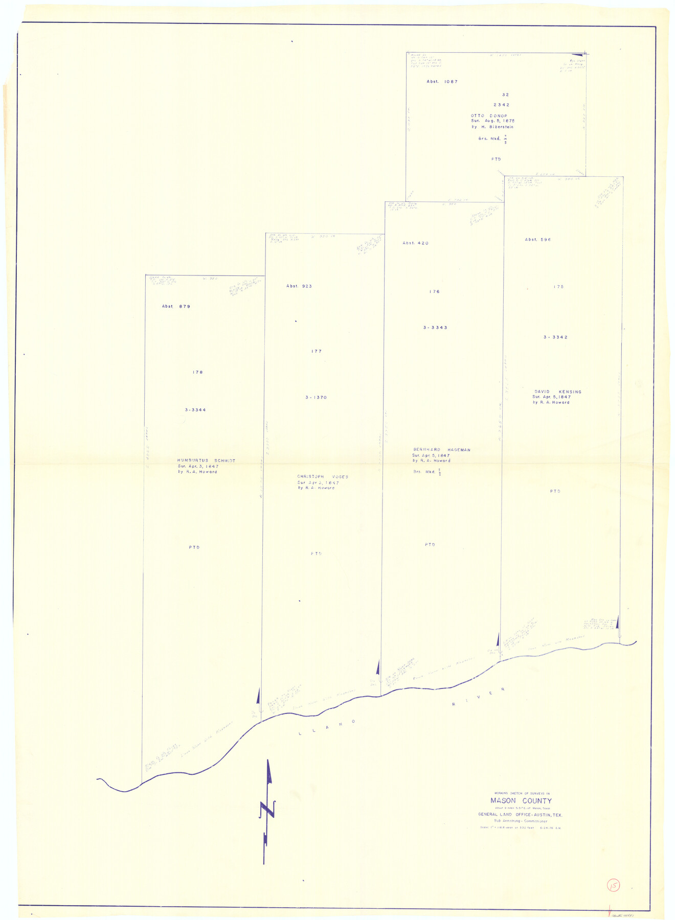
Mason County Working Sketch 15
-
Map/Doc
70851
-
Collection
General Map Collection
-
Object Dates
6/24/1976 (Creation Date)
-
People and Organizations
Elbert Menzel (Draftsman)
-
Counties
Mason
-
Subjects
Surveying Working Sketch
-
Height x Width
61.9 x 45.4 inches
157.2 x 115.3 cm
-
Scale
1" = 118.8 varas
Part of: General Map Collection
Newton County Rolled Sketch 25

Print $20.00
- Digital $50.00
Newton County Rolled Sketch 25
1893
Size 22.4 x 18.7 inches
Map/Doc 6853
Brazoria County Sketch File 28a

Print $40.00
- Digital $50.00
Brazoria County Sketch File 28a
1913
Size 21.0 x 15.2 inches
Map/Doc 10954
Lavaca County Working Sketch 24

Print $20.00
- Digital $50.00
Lavaca County Working Sketch 24
1985
Size 29.5 x 35.7 inches
Map/Doc 70377
Hamilton County Working Sketch 17

Print $20.00
- Digital $50.00
Hamilton County Working Sketch 17
1951
Size 44.4 x 25.0 inches
Map/Doc 63355
Montague County Working Sketch 32

Print $20.00
- Digital $50.00
Montague County Working Sketch 32
1975
Size 26.0 x 26.1 inches
Map/Doc 71098
Starr County Working Sketch 18

Print $20.00
- Digital $50.00
Starr County Working Sketch 18
1982
Size 29.5 x 34.3 inches
Map/Doc 63934
Roberts County Working Sketch 22

Print $20.00
- Digital $50.00
Roberts County Working Sketch 22
1978
Size 31.0 x 42.9 inches
Map/Doc 63548
Andrews County Rolled Sketch 42

Print $20.00
- Digital $50.00
Andrews County Rolled Sketch 42
Size 27.3 x 36.0 inches
Map/Doc 77182
Flight Mission No. DQO-7K, Frame 99, Galveston County

Print $20.00
- Digital $50.00
Flight Mission No. DQO-7K, Frame 99, Galveston County
1952
Size 18.7 x 22.5 inches
Map/Doc 85114
Hansford County Boundary File 3

Print $10.00
- Digital $50.00
Hansford County Boundary File 3
Size 13.6 x 8.7 inches
Map/Doc 54270
Presidio County Working Sketch 136

Print $20.00
- Digital $50.00
Presidio County Working Sketch 136
1990
Size 33.7 x 46.8 inches
Map/Doc 71814
[Gulf, Colorado & Santa Fe]
![64576, [Gulf, Colorado & Santa Fe], General Map Collection](https://historictexasmaps.com/wmedia_w700/maps/64576.tif.jpg)
Print $40.00
- Digital $50.00
[Gulf, Colorado & Santa Fe]
Size 32.4 x 84.9 inches
Map/Doc 64576
You may also like
Ellis County Boundary File 4

Print $14.00
- Digital $50.00
Ellis County Boundary File 4
Size 14.2 x 8.6 inches
Map/Doc 52983
The Chief Justice County of Mina. Lands in Conflict with Colorado County

Print $20.00
The Chief Justice County of Mina. Lands in Conflict with Colorado County
2020
Size 15.8 x 21.7 inches
Map/Doc 96062
Official Map of the City of Bryan from Actual Survey [West Part]
![76864, Official Map of the City of Bryan from Actual Survey [West Part], General Map Collection](https://historictexasmaps.com/wmedia_w700/maps/76864.tif.jpg)
Print $40.00
- Digital $50.00
Official Map of the City of Bryan from Actual Survey [West Part]
1898
Size 52.5 x 27.4 inches
Map/Doc 76864
Robertson County Working Sketch 15

Print $20.00
- Digital $50.00
Robertson County Working Sketch 15
1984
Size 28.7 x 25.2 inches
Map/Doc 63588
Denton County Working Sketch 38

Print $20.00
- Digital $50.00
Denton County Working Sketch 38
2010
Size 23.4 x 29.5 inches
Map/Doc 89571
Lavaca County Sketch File 4

Print $6.00
- Digital $50.00
Lavaca County Sketch File 4
Size 8.2 x 15.3 inches
Map/Doc 29636
Loving County Rolled Sketch 2A

Print $40.00
- Digital $50.00
Loving County Rolled Sketch 2A
1952
Size 41.8 x 71.0 inches
Map/Doc 9463
Bandera County Working Sketch 34

Print $20.00
- Digital $50.00
Bandera County Working Sketch 34
1963
Size 36.5 x 29.2 inches
Map/Doc 67630
Copy of Surveyor's Field Book, Morris Browning - In Blocks 7, 5 & 4, I&GNRRCo., Hutchinson and Carson Counties, Texas

Print $2.00
- Digital $50.00
Copy of Surveyor's Field Book, Morris Browning - In Blocks 7, 5 & 4, I&GNRRCo., Hutchinson and Carson Counties, Texas
1888
Size 6.9 x 8.8 inches
Map/Doc 62283
United States

Print $40.00
- Digital $50.00
United States
1961
Size 55.0 x 81.2 inches
Map/Doc 75922
The First Part of Captn. Pike's Chart of the Internal Part of Louisiana

Print $20.00
- Digital $50.00
The First Part of Captn. Pike's Chart of the Internal Part of Louisiana
1810
Size 19.6 x 21.2 inches
Map/Doc 95154
[Section 25, H. & G. N. Block 1 showing Duck Creek]
![90936, [Section 25, H. & G. N. Block 1 showing Duck Creek], Twichell Survey Records](https://historictexasmaps.com/wmedia_w700/maps/90936-1.tif.jpg)
Print $20.00
- Digital $50.00
[Section 25, H. & G. N. Block 1 showing Duck Creek]
Size 24.9 x 27.9 inches
Map/Doc 90936