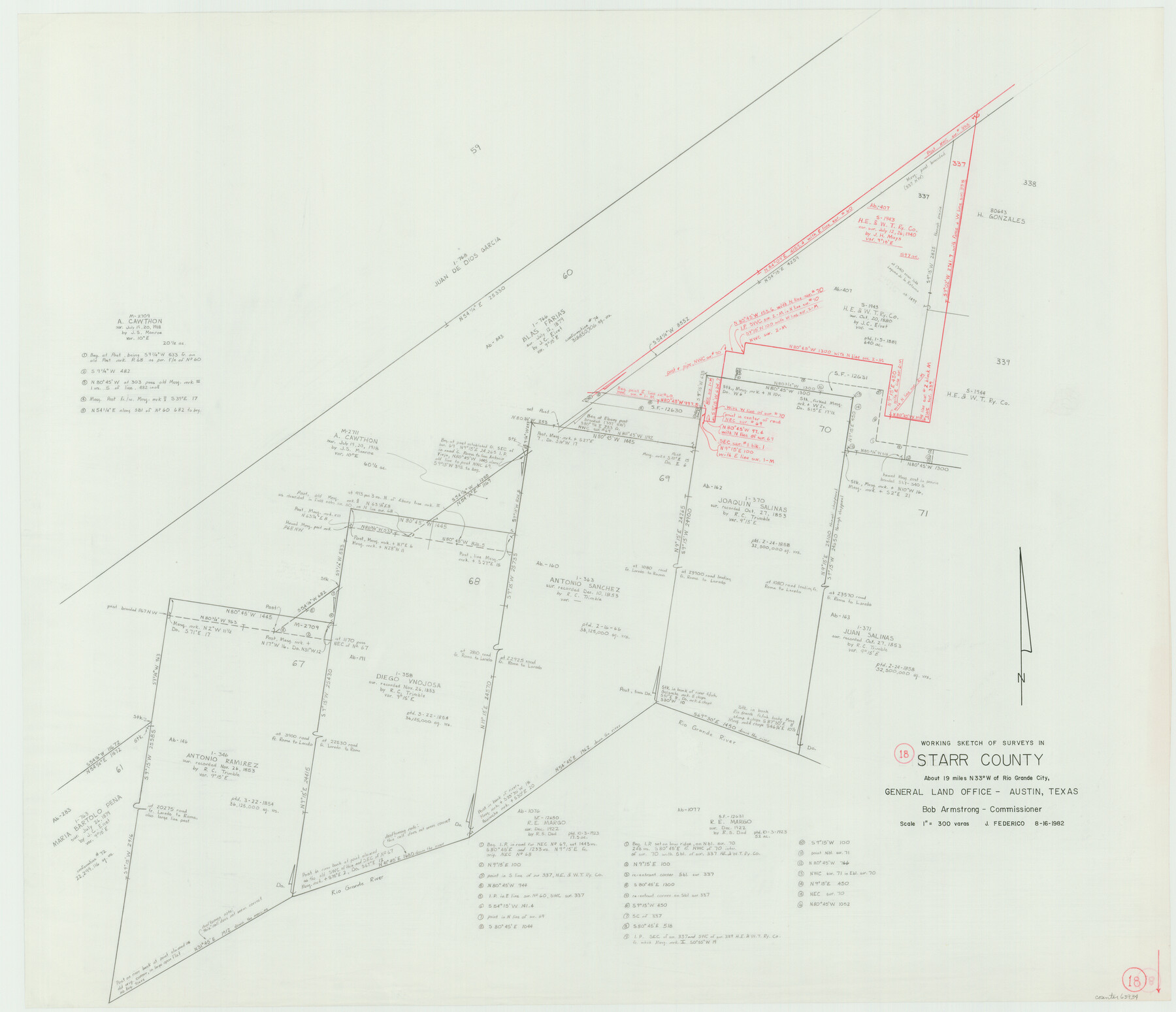
Starr County Working Sketch 18
-
Map/Doc
63934
-
Collection
General Map Collection
-
Object Dates
8/16/1982 (Creation Date)
-
People and Organizations
Jeff Federico (Draftsman)
-
Counties
Starr
-
Subjects
Surveying Working Sketch
-
Height x Width
29.5 x 34.3 inches
74.9 x 87.1 cm
-
Scale
1" = 300 varas
Part of: General Map Collection
San Jacinto County Working Sketch 20

Print $20.00
- Digital $50.00
San Jacinto County Working Sketch 20
1939
Size 30.3 x 24.0 inches
Map/Doc 63733
Index sheet to accompany map of survey for connecting the inland waters along margin of the Gulf of Mexico from Donaldsonville in Louisiana to the Rio Grande River in Texas

Print $20.00
- Digital $50.00
Index sheet to accompany map of survey for connecting the inland waters along margin of the Gulf of Mexico from Donaldsonville in Louisiana to the Rio Grande River in Texas
1874
Size 18.2 x 27.1 inches
Map/Doc 72696
Liberty County Working Sketch 47

Print $20.00
- Digital $50.00
Liberty County Working Sketch 47
1954
Size 28.3 x 24.6 inches
Map/Doc 70506
Kinney County Sketch File 34

Print $8.00
- Digital $50.00
Kinney County Sketch File 34
1941
Size 14.2 x 8.8 inches
Map/Doc 29181
Williamson County Rolled Sketch 10

Print $20.00
- Digital $50.00
Williamson County Rolled Sketch 10
1975
Size 24.8 x 19.2 inches
Map/Doc 8267
Flight Mission No. DQO-12K, Frame 37, Galveston County

Print $20.00
- Digital $50.00
Flight Mission No. DQO-12K, Frame 37, Galveston County
1952
Size 18.7 x 22.4 inches
Map/Doc 85228
Hunt County Rolled Sketch 5

Print $20.00
- Digital $50.00
Hunt County Rolled Sketch 5
1956
Size 22.9 x 23.0 inches
Map/Doc 6271
Cass County Sketch File 4

Print $6.00
- Digital $50.00
Cass County Sketch File 4
1853
Size 8.2 x 11.2 inches
Map/Doc 17398
Jeff Davis County Sketch File 39

Print $10.00
- Digital $50.00
Jeff Davis County Sketch File 39
Size 14.2 x 8.7 inches
Map/Doc 28057
Smith County Working Sketch 8

Print $20.00
- Digital $50.00
Smith County Working Sketch 8
1941
Size 28.9 x 22.7 inches
Map/Doc 63893


You may also like
Galveston County Rolled Sketch 25

Print $20.00
- Digital $50.00
Galveston County Rolled Sketch 25
1965
Size 18.6 x 24.2 inches
Map/Doc 5961
Texas, San Antonio Bay, Panther Point

Print $40.00
- Digital $50.00
Texas, San Antonio Bay, Panther Point
1934
Size 33.2 x 48.3 inches
Map/Doc 69995
Leon County Working Sketch 54

Print $20.00
- Digital $50.00
Leon County Working Sketch 54
1982
Size 34.0 x 42.0 inches
Map/Doc 70454
Kimble County Working Sketch 1

Print $20.00
- Digital $50.00
Kimble County Working Sketch 1
Size 14.7 x 18.3 inches
Map/Doc 70069
Starr County Sketch File 13

Print $20.00
- Digital $50.00
Starr County Sketch File 13
1886
Size 12.4 x 19.5 inches
Map/Doc 12329
Culberson County Working Sketch 46

Print $20.00
- Digital $50.00
Culberson County Working Sketch 46
1971
Size 25.9 x 37.4 inches
Map/Doc 68500
Cameron County Rolled Sketch US

Print $20.00
- Digital $50.00
Cameron County Rolled Sketch US
1913
Size 31.1 x 26.3 inches
Map/Doc 5398
[Texas and Pacific Railway Company, Block 44, Township One South]
![89846, [Texas and Pacific Railway Company, Block 44, Township One South], Twichell Survey Records](https://historictexasmaps.com/wmedia_w700/maps/89846-1.tif.jpg)
Print $40.00
- Digital $50.00
[Texas and Pacific Railway Company, Block 44, Township One South]
1912
Size 41.1 x 56.4 inches
Map/Doc 89846
Calhoun County Boundary File 3

Print $8.00
- Digital $50.00
Calhoun County Boundary File 3
Size 11.3 x 8.7 inches
Map/Doc 50975
Flight Mission No. DAG-19K, Frame 56, Matagorda County

Print $20.00
- Digital $50.00
Flight Mission No. DAG-19K, Frame 56, Matagorda County
1952
Size 18.5 x 22.3 inches
Map/Doc 86383
Wharton County Boundary File 1b

Print $20.00
- Digital $50.00
Wharton County Boundary File 1b
Size 15.1 x 26.6 inches
Map/Doc 59855
Anderson County

Print $20.00
- Digital $50.00
Anderson County
1871
Size 20.2 x 21.9 inches
Map/Doc 3227