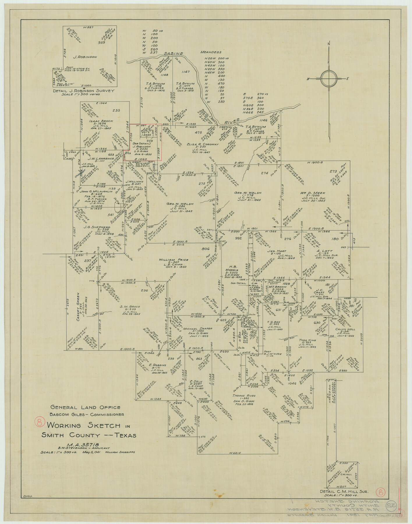
Smith County Working Sketch 8
-
Map/Doc
63893
-
Collection
General Map Collection
-
Object Dates
5/5/1941 (Creation Date)
-
People and Organizations
William Shirriffs (Draftsman)
-
Counties
Smith
-
Subjects
Surveying Working Sketch
-
Height x Width
28.9 x 22.7 inches
73.4 x 57.7 cm
-
Scale
1" = 500 varas
Part of: General Map Collection
Rusk County Working Sketch 37b

Print $40.00
- Digital $50.00
Rusk County Working Sketch 37b
2007
Size 50.0 x 31.0 inches
Map/Doc 87497
Knox County Rolled Sketch 23

Print $20.00
- Digital $50.00
Knox County Rolled Sketch 23
1989
Size 34.4 x 29.0 inches
Map/Doc 76408
Traced from Genl. Arista's map captured by the American Army under Genl. Taylor at Resaca de la Palma 9th May '46 and presented to James K. Polk, President U. States

Print $20.00
- Digital $50.00
Traced from Genl. Arista's map captured by the American Army under Genl. Taylor at Resaca de la Palma 9th May '46 and presented to James K. Polk, President U. States
1846
Size 18.4 x 27.6 inches
Map/Doc 73059
Map of R. H. Welder Ranch, San Patricio County, Texas

Print $40.00
- Digital $50.00
Map of R. H. Welder Ranch, San Patricio County, Texas
1953
Size 30.0 x 61.4 inches
Map/Doc 61406
Duval County Sketch File 42

Print $4.00
- Digital $50.00
Duval County Sketch File 42
1936
Size 14.4 x 8.8 inches
Map/Doc 21394
Val Verde County Sketch File B2

Print $20.00
- Digital $50.00
Val Verde County Sketch File B2
1910
Size 24.5 x 12.2 inches
Map/Doc 12544
Stephens County Sketch File 28

Print $14.00
- Digital $50.00
Stephens County Sketch File 28
1996
Size 14.2 x 8.6 inches
Map/Doc 37104
University Land Field Notes for Blocks 39, 41, 42, 44, 45, 46, 47, 50, and 51 in Crockett County, Blocks 38 and 40 in Crockett and Irion Counties, and Blocks 48 and 49 in Crockett and Reagan Counties, and Block 43 in Crockett, Irion, and Reagan Counties

University Land Field Notes for Blocks 39, 41, 42, 44, 45, 46, 47, 50, and 51 in Crockett County, Blocks 38 and 40 in Crockett and Irion Counties, and Blocks 48 and 49 in Crockett and Reagan Counties, and Block 43 in Crockett, Irion, and Reagan Counties
Map/Doc 81718
City of Austin, Texas and Suburban Territory

Print $40.00
- Digital $50.00
City of Austin, Texas and Suburban Territory
1952
Size 52.9 x 47.2 inches
Map/Doc 73582
Stephens County Working Sketch 20

Print $20.00
- Digital $50.00
Stephens County Working Sketch 20
1972
Size 26.7 x 30.6 inches
Map/Doc 63963
Sabine Bank to East Bay including Heald Bank

Print $20.00
- Digital $50.00
Sabine Bank to East Bay including Heald Bank
1967
Size 45.1 x 34.3 inches
Map/Doc 69848
Flight Mission No. DCL-6C, Frame 77, Kenedy County

Print $20.00
- Digital $50.00
Flight Mission No. DCL-6C, Frame 77, Kenedy County
1943
Size 18.5 x 22.3 inches
Map/Doc 85919
You may also like
Outer Continental Shelf Leasing Maps (Texas Offshore Operations)

Print $20.00
- Digital $50.00
Outer Continental Shelf Leasing Maps (Texas Offshore Operations)
Size 23.4 x 13.0 inches
Map/Doc 75854
Kent County Boundary File 3

Print $8.00
- Digital $50.00
Kent County Boundary File 3
Size 11.2 x 8.6 inches
Map/Doc 55824
Flight Mission No. CUI-1H, Frame 142, Milam County

Print $20.00
- Digital $50.00
Flight Mission No. CUI-1H, Frame 142, Milam County
1951
Size 18.5 x 22.2 inches
Map/Doc 86608
Presidio County Working Sketch 98

Print $20.00
- Digital $50.00
Presidio County Working Sketch 98
1978
Size 30.9 x 31.7 inches
Map/Doc 71775
Nolan County Sketch File 3

Print $20.00
- Digital $50.00
Nolan County Sketch File 3
Size 8.0 x 36.6 inches
Map/Doc 42161
[Corpus Christi Bay, Padre Island, Mustang Island, Laguna de la Madre, King and Kenedy's Pasture]
![73041, [Corpus Christi Bay, Padre Island, Mustang Island, Laguna de la Madre, King and Kenedy's Pasture], General Map Collection](https://historictexasmaps.com/wmedia_w700/maps/73041.tif.jpg)
Print $20.00
- Digital $50.00
[Corpus Christi Bay, Padre Island, Mustang Island, Laguna de la Madre, King and Kenedy's Pasture]
Size 26.2 x 18.1 inches
Map/Doc 73041
La Salle County Working Sketch 19

Print $20.00
- Digital $50.00
La Salle County Working Sketch 19
1941
Size 24.6 x 31.4 inches
Map/Doc 70320
Flight Mission No. BRA-7M, Frame 186, Jefferson County

Print $20.00
- Digital $50.00
Flight Mission No. BRA-7M, Frame 186, Jefferson County
1953
Size 18.4 x 22.2 inches
Map/Doc 85554
Flight Mission No. BQY-4M, Frame 62, Harris County

Print $20.00
- Digital $50.00
Flight Mission No. BQY-4M, Frame 62, Harris County
1953
Size 18.7 x 22.5 inches
Map/Doc 85271
The Republic County of Fayette. January 29, 1842

Print $20.00
The Republic County of Fayette. January 29, 1842
2020
Size 14.7 x 21.7 inches
Map/Doc 96134
Medina County Working Sketch 3

Print $40.00
- Digital $50.00
Medina County Working Sketch 3
1945
Size 52.6 x 37.1 inches
Map/Doc 70918
Brewster County Rolled Sketch 114

Print $20.00
- Digital $50.00
Brewster County Rolled Sketch 114
1964
Size 11.4 x 17.7 inches
Map/Doc 5284