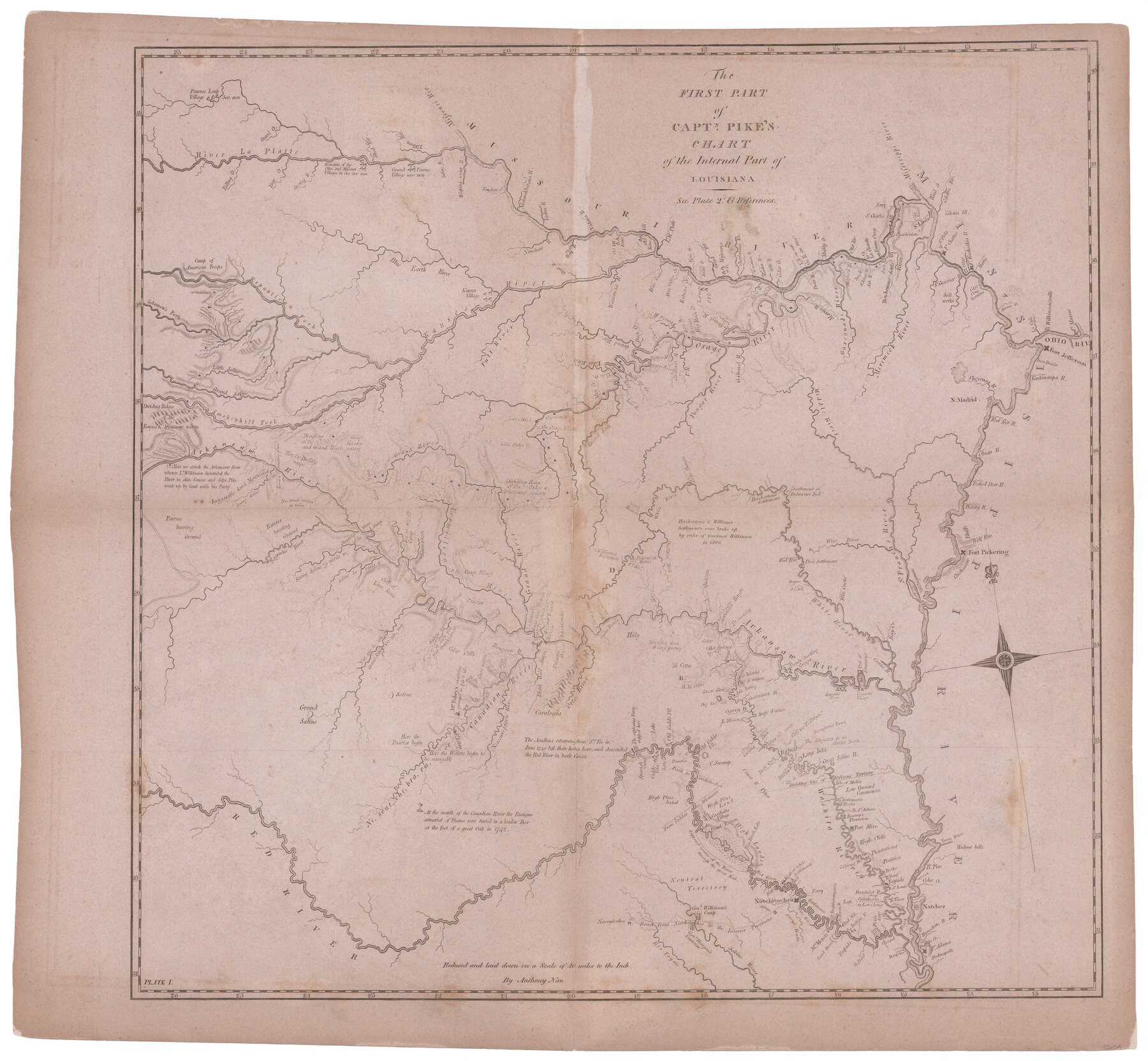
The First Part of Captn. Pike's Chart of the Internal Part of Louisiana
-
Map/Doc
95154
-
Collection
General Map Collection
-
Object Dates
1810 (Creation Date)
-
People and Organizations
Anthony Nau (Draftsman)
Zebulon Montgomery Pike (Explorer)
-
Subjects
Atlas
-
Height x Width
19.6 x 21.2 inches
49.8 x 53.8 cm
-
Medium
paper, etching/engraving/lithograph
-
Scale
1 inch = 40 miles
-
Comments
From Pike's Expedition Atlas
-
URLs
https://medium.com/save-texas-history/texas-general-land-office-acquires-and-conserves-atlas-of-maps-made-by-captain-zebulon-m-pike-82f8e8375b28
Part of: General Map Collection
San Jacinto County Sketch File 3

Print $4.00
San Jacinto County Sketch File 3
1857
Size 10.3 x 8.1 inches
Map/Doc 35698
State University and PSL Blocks 1 through 77 in Andrews, Culberson, Crane, Ector, El Paso, Gaines, Loving, Martin, Reeves, Tom Green, Ward County, and Winkler Counties

State University and PSL Blocks 1 through 77 in Andrews, Culberson, Crane, Ector, El Paso, Gaines, Loving, Martin, Reeves, Tom Green, Ward County, and Winkler Counties
Map/Doc 81652
Flight Mission No. CLL-1N, Frame 17, Willacy County

Print $20.00
- Digital $50.00
Flight Mission No. CLL-1N, Frame 17, Willacy County
1954
Size 18.5 x 22.1 inches
Map/Doc 87004
Flight Mission No. DAH-17M, Frame 66, Orange County

Print $20.00
- Digital $50.00
Flight Mission No. DAH-17M, Frame 66, Orange County
1953
Size 18.6 x 22.3 inches
Map/Doc 86900
Armstrong County Boundary File 1c

Print $10.00
- Digital $50.00
Armstrong County Boundary File 1c
Size 14.1 x 8.7 inches
Map/Doc 50132
Guadalupe County

Print $20.00
- Digital $50.00
Guadalupe County
1869
Size 27.7 x 22.3 inches
Map/Doc 3607
Uvalde County Working Sketch 52

Print $20.00
- Digital $50.00
Uvalde County Working Sketch 52
1982
Size 45.2 x 35.8 inches
Map/Doc 72122
Gaines County Rolled Sketch 15B

Print $40.00
- Digital $50.00
Gaines County Rolled Sketch 15B
Size 207.7 x 26.0 inches
Map/Doc 9037
Gray County Sketch File 6

Print $20.00
- Digital $50.00
Gray County Sketch File 6
1882
Size 26.3 x 21.4 inches
Map/Doc 11575
Map of The Surveyed Part of Peters Colony Texas

Print $40.00
- Digital $50.00
Map of The Surveyed Part of Peters Colony Texas
1852
Size 53.0 x 28.1 inches
Map/Doc 1964
Reeves County Rolled Sketch 33

Print $20.00
- Digital $50.00
Reeves County Rolled Sketch 33
Size 24.2 x 36.5 inches
Map/Doc 7502
Hardin County Sketch File 61

Print $20.00
- Digital $50.00
Hardin County Sketch File 61
1933
Size 18.9 x 24.6 inches
Map/Doc 11636
You may also like
Mitchell County Sketch File 14

Print $20.00
- Digital $50.00
Mitchell County Sketch File 14
1930
Size 17.5 x 20.5 inches
Map/Doc 12101
Webb County Sketch File 9-1

Print $20.00
- Digital $50.00
Webb County Sketch File 9-1
1879
Size 15.8 x 15.7 inches
Map/Doc 12622
Flight Mission No. CGI-4N, Frame 21, Cameron County

Print $20.00
- Digital $50.00
Flight Mission No. CGI-4N, Frame 21, Cameron County
1954
Size 18.5 x 22.2 inches
Map/Doc 84654

Harris County Sketch File 20a

Print $4.00
- Digital $50.00
Harris County Sketch File 20a
Size 8.8 x 14.4 inches
Map/Doc 25371
Glasscock County Working Sketch 14

Print $40.00
- Digital $50.00
Glasscock County Working Sketch 14
1984
Size 67.0 x 42.1 inches
Map/Doc 63187
Red River County Working Sketch 25

Print $20.00
- Digital $50.00
Red River County Working Sketch 25
1959
Size 23.0 x 22.2 inches
Map/Doc 72008
Houston County Working Sketch 16

Print $20.00
- Digital $50.00
Houston County Working Sketch 16
1962
Size 13.4 x 15.6 inches
Map/Doc 66246
A Map of the United States of Mexico as organized and defined by the several Acts of the Congress of that Republic

Print $20.00
A Map of the United States of Mexico as organized and defined by the several Acts of the Congress of that Republic
1826
Size 23.2 x 28.9 inches
Map/Doc 93635
Stonewall County Working Sketch 21

Print $20.00
- Digital $50.00
Stonewall County Working Sketch 21
1961
Size 30.4 x 26.8 inches
Map/Doc 62328
Mills County Sketch File 1A

Print $20.00
- Digital $50.00
Mills County Sketch File 1A
1852
Size 33.6 x 20.1 inches
Map/Doc 12092
Morris County Rolled Sketch 2A

Print $20.00
- Digital $50.00
Morris County Rolled Sketch 2A
Size 36.5 x 20.0 inches
Map/Doc 10283