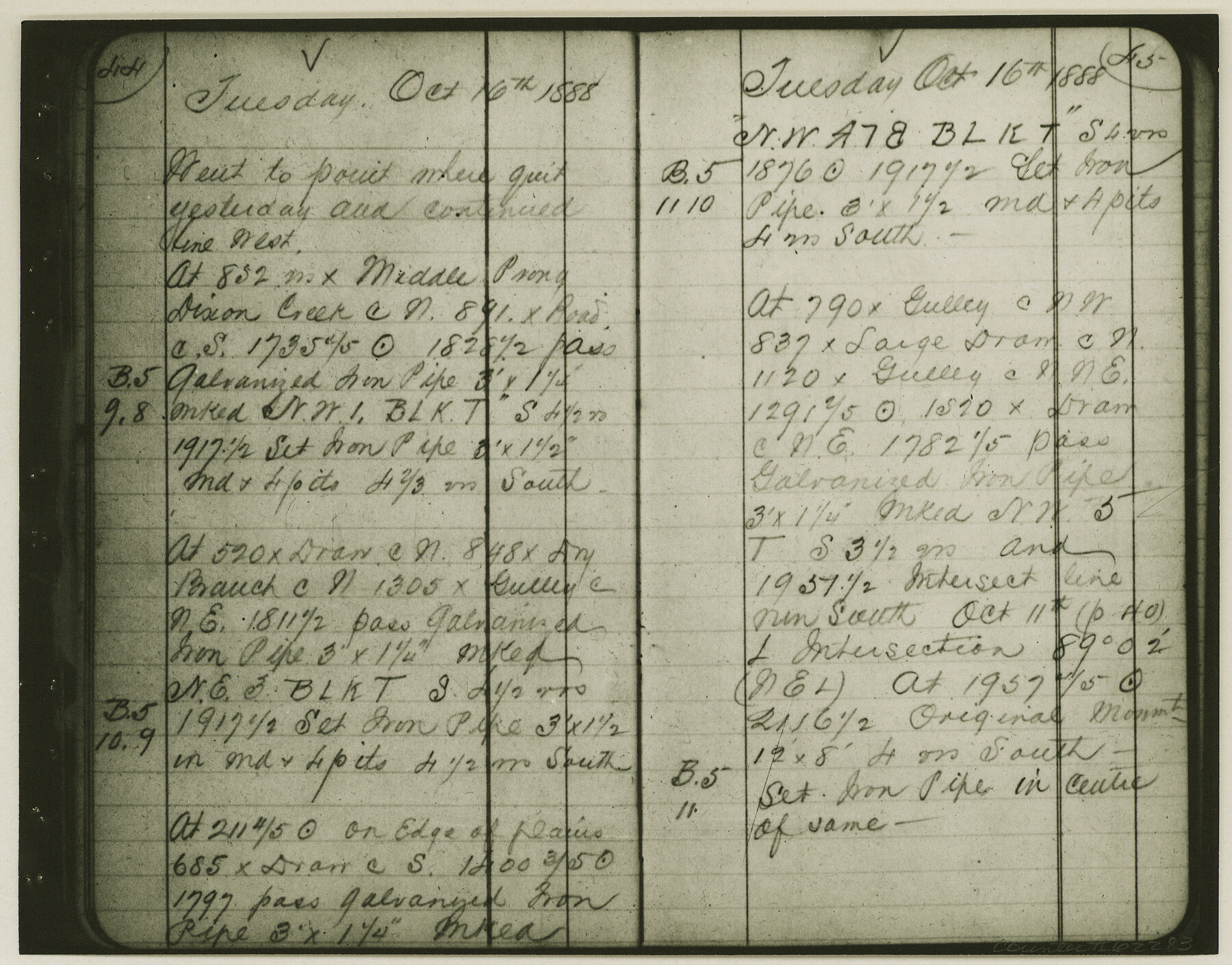
Copy of Surveyor's Field Book, Morris Browning - In Blocks 7, 5 & 4, I&GNRRCo., Hutchinson and Carson Counties, Texas
K-7-70
-
Map/Doc
62283
-
Collection
General Map Collection
-
Object Dates
1888/10/22 (Creation Date)
-
People and Organizations
Morris Browning (Surveyor/Engineer)
-
Counties
Hutchinson Carson
-
Subjects
Cadastral
-
Height x Width
6.9 x 8.8 inches
17.5 x 22.4 cm
-
Comments
Copy of Surveyor's field book presented to the General Land Office by Morris Browning on February 3, 1941.
Surveyed from September 14, 1888 to October 22, 1888.
Part of: General Map Collection
Newton County Working Sketch 1
![71247, Newton County Working Sketch 1, General Map Collection](https://historictexasmaps.com/wmedia_w700/maps/71247.tif.jpg)
Print $20.00
- Digital $50.00
Newton County Working Sketch 1
Size 25.5 x 25.9 inches
Map/Doc 71247
San Patricio County Sketch File 28
![36087, San Patricio County Sketch File 28, General Map Collection](https://historictexasmaps.com/wmedia_w700/pdf_converted_jpg/qi_pdf_thumbnail_14098.jpg)
Print $53.00
San Patricio County Sketch File 28
1935
Size 9.4 x 7.0 inches
Map/Doc 36087
Hood County Working Sketch 9
![66203, Hood County Working Sketch 9, General Map Collection](https://historictexasmaps.com/wmedia_w700/maps/66203.tif.jpg)
Print $20.00
- Digital $50.00
Hood County Working Sketch 9
Size 28.0 x 31.7 inches
Map/Doc 66203
Jones County Sketch File 19
![28516, Jones County Sketch File 19, General Map Collection](https://historictexasmaps.com/wmedia_w700/pdf_converted_jpg/qi_pdf_thumbnail_12348.jpg)
Print $56.00
- Digital $50.00
Jones County Sketch File 19
1875
Size 11.1 x 8.6 inches
Map/Doc 28516
Flight Mission No. BQR-3K, Frame 161, Brazoria County
![83988, Flight Mission No. BQR-3K, Frame 161, Brazoria County, General Map Collection](https://historictexasmaps.com/wmedia_w700/pdf_converted_jpg/qi_pdf_thumbnail_31207.jpg)
Print $20.00
- Digital $50.00
Flight Mission No. BQR-3K, Frame 161, Brazoria County
1952
Size 18.7 x 22.4 inches
Map/Doc 83988
Chambers County Rolled Sketch 8
![8612, Chambers County Rolled Sketch 8, General Map Collection](https://historictexasmaps.com/wmedia_w700/maps/8612.tif.jpg)
Print $20.00
- Digital $50.00
Chambers County Rolled Sketch 8
Size 39.8 x 30.5 inches
Map/Doc 8612
Winkler County Working Sketch 11
![72605, Winkler County Working Sketch 11, General Map Collection](https://historictexasmaps.com/wmedia_w700/maps/72605.tif.jpg)
Print $40.00
- Digital $50.00
Winkler County Working Sketch 11
Size 28.5 x 81.4 inches
Map/Doc 72605
Flight Mission No. DIX-5P, Frame 151, Aransas County
![83813, Flight Mission No. DIX-5P, Frame 151, Aransas County, General Map Collection](https://historictexasmaps.com/wmedia_w700/pdf_converted_jpg/qi_pdf_thumbnail_31034.jpg)
Print $20.00
- Digital $50.00
Flight Mission No. DIX-5P, Frame 151, Aransas County
1956
Size 17.8 x 18.2 inches
Map/Doc 83813
Donley County Sketch File B1
![11371, Donley County Sketch File B1, General Map Collection](https://historictexasmaps.com/wmedia_w700/pdf_converted_jpg/qi_pdf_thumbnail_7841.jpg)
Print $20.00
- Digital $50.00
Donley County Sketch File B1
Size 32.0 x 21.3 inches
Map/Doc 11371
Flight Mission No. CGI-1N, Frame 175, Cameron County
![84510, Flight Mission No. CGI-1N, Frame 175, Cameron County, General Map Collection](https://historictexasmaps.com/wmedia_w700/pdf_converted_jpg/qi_pdf_thumbnail_31725.jpg)
Print $20.00
- Digital $50.00
Flight Mission No. CGI-1N, Frame 175, Cameron County
1955
Size 18.7 x 22.2 inches
Map/Doc 84510
Uvalde County Working Sketch 32
![72102, Uvalde County Working Sketch 32, General Map Collection](https://historictexasmaps.com/wmedia_w700/maps/72102.tif.jpg)
Print $20.00
- Digital $50.00
Uvalde County Working Sketch 32
Size 27.2 x 41.8 inches
Map/Doc 72102
Kinney County Rolled Sketch 16
![9355, Kinney County Rolled Sketch 16, General Map Collection](https://historictexasmaps.com/wmedia_w700/maps/9355.tif.jpg)
Print $20.00
- Digital $50.00
Kinney County Rolled Sketch 16
1963
Size 37.4 x 44.7 inches
Map/Doc 9355
You may also like
Flight Mission No. BRA-9M, Frame 60, Jefferson County
![85643, Flight Mission No. BRA-9M, Frame 60, Jefferson County, General Map Collection](https://historictexasmaps.com/wmedia_w700/pdf_converted_jpg/qi_pdf_thumbnail_32840.jpg)
Print $20.00
- Digital $50.00
Flight Mission No. BRA-9M, Frame 60, Jefferson County
1953
Size 18.6 x 22.4 inches
Map/Doc 85643
The Mercer Colony. January 29, 1844
![96361, The Mercer Colony. January 29, 1844, Nancy and Jim Tiller Digital Collection](https://historictexasmaps.com/wmedia_w700/maps/96361.tif.jpg)
Print $20.00
- Digital $50.00
The Mercer Colony. January 29, 1844
2020
Size 9.9 x 10.8 inches
Map/Doc 96361
Matagorda County Rolled Sketch 35
![6696, Matagorda County Rolled Sketch 35, General Map Collection](https://historictexasmaps.com/wmedia_w700/maps/6696-1.tif.jpg)
Print $20.00
- Digital $50.00
Matagorda County Rolled Sketch 35
1903
Size 18.6 x 38.0 inches
Map/Doc 6696
[Block J and vicinity]
![89949, [Block J and vicinity], Twichell Survey Records](https://historictexasmaps.com/wmedia_w700/maps/89949-1.tif.jpg)
Print $40.00
- Digital $50.00
[Block J and vicinity]
Size 53.3 x 36.9 inches
Map/Doc 89949
Donley County Working Sketch 6
![68739, Donley County Working Sketch 6, General Map Collection](https://historictexasmaps.com/wmedia_w700/maps/68739.tif.jpg)
Print $20.00
- Digital $50.00
Donley County Working Sketch 6
Size 34.3 x 42.2 inches
Map/Doc 68739
Sulphur River, North Extension, Turner Lake Sheet
![65158, Sulphur River, North Extension, Turner Lake Sheet, General Map Collection](https://historictexasmaps.com/wmedia_w700/maps/65158.tif.jpg)
Print $4.00
- Digital $50.00
Sulphur River, North Extension, Turner Lake Sheet
1922
Size 17.8 x 18.6 inches
Map/Doc 65158
Geological Map of the route explored by Capt. Jno. Pope, Corps of Topl. Engrs. near the 32nd Parallel of North Latitude From the Red River to the Rio Grande
![95149, Geological Map of the route explored by Capt. Jno. Pope, Corps of Topl. Engrs. near the 32nd Parallel of North Latitude From the Red River to the Rio Grande, General Map Collection](https://historictexasmaps.com/wmedia_w700/maps/95149.tif.jpg)
Print $20.00
- Digital $50.00
Geological Map of the route explored by Capt. Jno. Pope, Corps of Topl. Engrs. near the 32nd Parallel of North Latitude From the Red River to the Rio Grande
Size 11.5 x 24.7 inches
Map/Doc 95149
Flight Mission No. DAG-21K, Frame 39, Matagorda County
![86406, Flight Mission No. DAG-21K, Frame 39, Matagorda County, General Map Collection](https://historictexasmaps.com/wmedia_w700/pdf_converted_jpg/qi_pdf_thumbnail_33550.jpg)
Print $20.00
- Digital $50.00
Flight Mission No. DAG-21K, Frame 39, Matagorda County
1952
Size 18.6 x 22.3 inches
Map/Doc 86406
Lake Corpus Christi and a city map of Mathis, Texas [Recto]
![94170, Lake Corpus Christi and a city map of Mathis, Texas [Recto], General Map Collection](https://historictexasmaps.com/wmedia_w700/maps/94170.tif.jpg)
Lake Corpus Christi and a city map of Mathis, Texas [Recto]
1984
Size 29.2 x 22.8 inches
Map/Doc 94170
Andrews County Working Sketch 19
![67065, Andrews County Working Sketch 19, General Map Collection](https://historictexasmaps.com/wmedia_w700/maps/67065.tif.jpg)
Print $20.00
- Digital $50.00
Andrews County Working Sketch 19
1964
Size 24.9 x 23.5 inches
Map/Doc 67065
McMullen County Working Sketch 45
![70746, McMullen County Working Sketch 45, General Map Collection](https://historictexasmaps.com/wmedia_w700/maps/70746.tif.jpg)
Print $20.00
- Digital $50.00
McMullen County Working Sketch 45
Size 47.6 x 38.5 inches
Map/Doc 70746
Hemphill County Working Sketch 17
![66112, Hemphill County Working Sketch 17, General Map Collection](https://historictexasmaps.com/wmedia_w700/maps/66112.tif.jpg)
Print $20.00
- Digital $50.00
Hemphill County Working Sketch 17
Size 33.6 x 45.0 inches
Map/Doc 66112