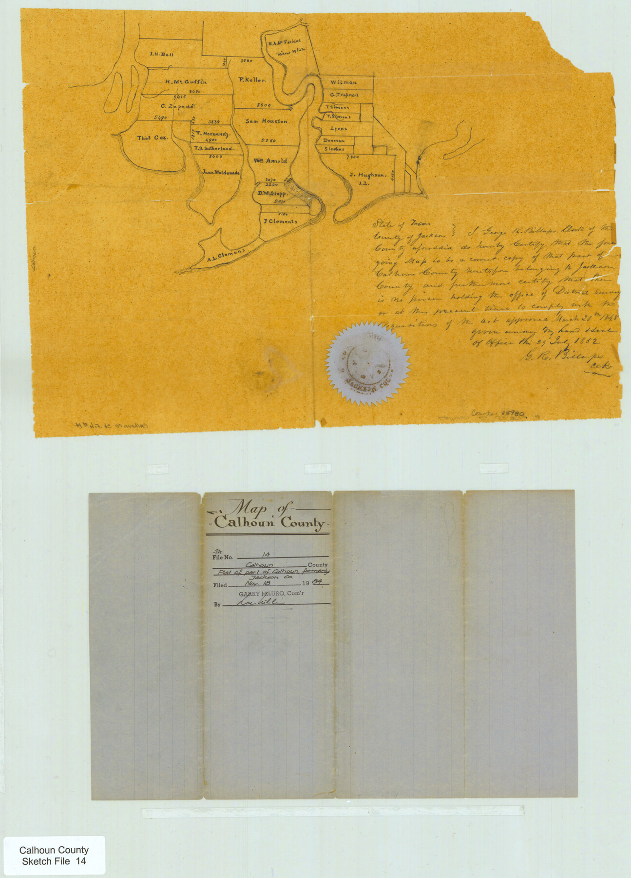
Calhoun County Sketch File 14
[Plat of the eastern part of Calhoun County and parts of Jackson and Matagorda Counties]
-
Map/Doc
35980
-
Collection
General Map Collection
-
Object Dates
1852/7/29 (Creation Date)
1984/11/18 (File Date)
-
Counties
Calhoun Jackson Matagorda
-
Subjects
Surveying Sketch File
-
Height x Width
22.6 x 16.2 inches
57.4 x 41.1 cm
-
Medium
paper, manuscript
Part of: General Map Collection
Newton County Rolled Sketch 10

Print $40.00
- Digital $50.00
Newton County Rolled Sketch 10
1949
Size 27.4 x 59.6 inches
Map/Doc 9575
Irion County Rolled Sketch 9

Print $20.00
- Digital $50.00
Irion County Rolled Sketch 9
1940
Size 31.9 x 30.6 inches
Map/Doc 6321
Blanco County Working Sketch 11

Print $3.00
- Digital $50.00
Blanco County Working Sketch 11
1941
Size 10.8 x 10.4 inches
Map/Doc 67371

Fayette County Boundary File 2a

Print $8.00
- Digital $50.00
Fayette County Boundary File 2a
Size 14.9 x 9.3 inches
Map/Doc 53345
Burleson County Working Sketch 16

Print $3.00
- Digital $50.00
Burleson County Working Sketch 16
1980
Size 10.1 x 14.1 inches
Map/Doc 67735
Donley County Working Sketch Graphic Index

Print $20.00
- Digital $50.00
Donley County Working Sketch Graphic Index
1944
Size 44.6 x 39.0 inches
Map/Doc 76526
Kerr County Working Sketch 2

Print $20.00
- Digital $50.00
Kerr County Working Sketch 2
1926
Size 18.6 x 17.9 inches
Map/Doc 70033
[Texas & Pacific Railway through Callahan County]
![64233, [Texas & Pacific Railway through Callahan County], General Map Collection](https://historictexasmaps.com/wmedia_w700/maps/64233.tif.jpg)
Print $20.00
- Digital $50.00
[Texas & Pacific Railway through Callahan County]
1918
Size 20.5 x 9.4 inches
Map/Doc 64233
Flight Mission No. DAG-23K, Frame 12, Matagorda County

Print $20.00
- Digital $50.00
Flight Mission No. DAG-23K, Frame 12, Matagorda County
1953
Size 15.5 x 15.5 inches
Map/Doc 86474
Hamilton County Working Sketch 21

Print $40.00
- Digital $50.00
Hamilton County Working Sketch 21
1955
Size 52.4 x 43.7 inches
Map/Doc 63359
Uvalde County Working Sketch 4

Print $20.00
- Digital $50.00
Uvalde County Working Sketch 4
1920
Size 23.1 x 17.1 inches
Map/Doc 72074
You may also like
Wharton County Working Sketch 15

Print $20.00
- Digital $50.00
Wharton County Working Sketch 15
1957
Size 22.1 x 25.9 inches
Map/Doc 72479
Brazos County Working Sketch 3

Print $20.00
- Digital $50.00
Brazos County Working Sketch 3
1976
Size 22.0 x 18.4 inches
Map/Doc 67478
Intracoastal Waterway in Texas - Corpus Christi to Point Isabel including Arroyo Colorado to Mo. Pac. R.R. Bridge Near Harlingen

Print $20.00
- Digital $50.00
Intracoastal Waterway in Texas - Corpus Christi to Point Isabel including Arroyo Colorado to Mo. Pac. R.R. Bridge Near Harlingen
1934
Size 22.1 x 32.7 inches
Map/Doc 61887
Gregg County Working Sketch 7

Print $20.00
- Digital $50.00
Gregg County Working Sketch 7
1934
Size 32.2 x 21.0 inches
Map/Doc 63273
Live Oak County Working Sketch 39

Print $40.00
- Digital $50.00
Live Oak County Working Sketch 39
2006
Size 36.4 x 48.6 inches
Map/Doc 94156
Hudspeth County Rolled Sketch 20

Print $20.00
- Digital $50.00
Hudspeth County Rolled Sketch 20
Size 39.5 x 44.3 inches
Map/Doc 76028
Houston County Sketch File 22

Print $8.00
- Digital $50.00
Houston County Sketch File 22
1852
Size 12.6 x 8.2 inches
Map/Doc 26789
Flight Mission No. DQN-7K, Frame 32, Calhoun County

Print $20.00
- Digital $50.00
Flight Mission No. DQN-7K, Frame 32, Calhoun County
1953
Size 18.6 x 22.2 inches
Map/Doc 84470
Nueces County Rolled Sketch 110

Print $20.00
- Digital $50.00
Nueces County Rolled Sketch 110
1990
Size 24.1 x 37.5 inches
Map/Doc 7117
Flight Mission No. DQO-2K, Frame 99, Galveston County

Print $20.00
- Digital $50.00
Flight Mission No. DQO-2K, Frame 99, Galveston County
1952
Size 18.8 x 22.5 inches
Map/Doc 85026
[Portions of Blocks T1, B, and T]
![90950, [Portions of Blocks T1, B, and T], Twichell Survey Records](https://historictexasmaps.com/wmedia_w700/maps/90950-1.tif.jpg)
Print $2.00
- Digital $50.00
[Portions of Blocks T1, B, and T]
1910
Size 13.8 x 4.3 inches
Map/Doc 90950
El Paso Street and Vicinity Map (Recto)

El Paso Street and Vicinity Map (Recto)
1962
Size 18.3 x 30.8 inches
Map/Doc 94175