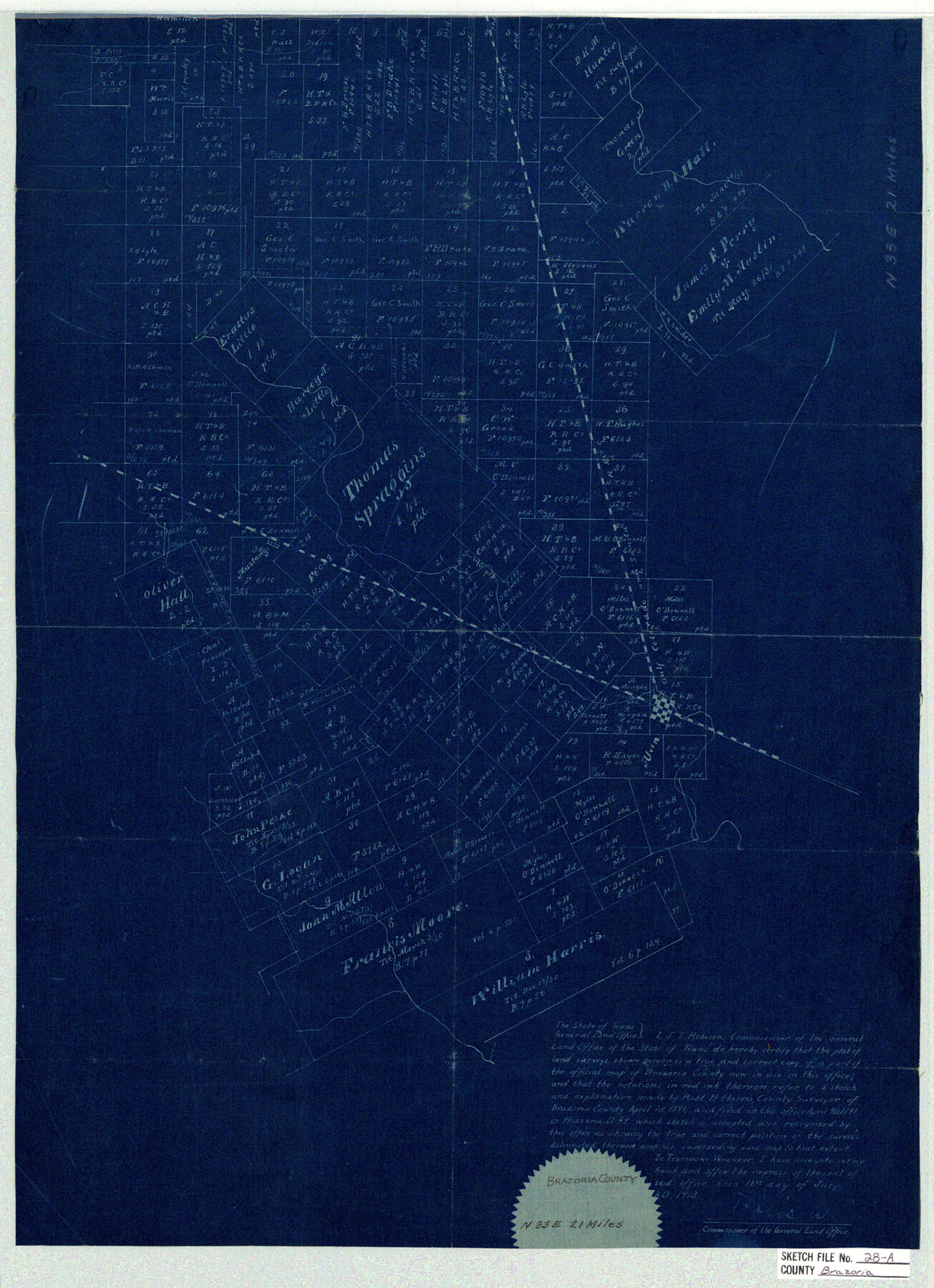
Brazoria County Sketch File 28a
[Northeast part of GLO official county map for Brazoria County]
-
Map/Doc
10954
-
Collection
General Map Collection
-
Object Dates
1913/7/16 (Creation Date)
-
Counties
Brazoria
-
Subjects
Surveying Sketch File
-
Height x Width
21.0 x 15.2 inches
53.3 x 38.6 cm
-
Medium
blueprint/diazo
-
Features
Mustang
Alvin
GC&SF
Part of: General Map Collection
Tyler County Sketch File 6a

Print $4.00
- Digital $50.00
Tyler County Sketch File 6a
Size 10.1 x 8.0 inches
Map/Doc 38635
Aransas County Sketch File 29

Print $24.00
- Digital $50.00
Aransas County Sketch File 29
Size 7.8 x 8.1 inches
Map/Doc 13234
Nueces County NRC Article 33.136 Sketch 24

Print $24.00
Nueces County NRC Article 33.136 Sketch 24
2024
Map/Doc 97424
Clay County Sketch File 9a

Print $6.00
- Digital $50.00
Clay County Sketch File 9a
1855
Size 10.7 x 6.1 inches
Map/Doc 18403
Texas, Matagorda Bay, Matagorda Peninsula, Central Section

Print $20.00
- Digital $50.00
Texas, Matagorda Bay, Matagorda Peninsula, Central Section
1933
Size 28.3 x 42.7 inches
Map/Doc 69987
Henderson County Boundary File 3

Print $32.00
- Digital $50.00
Henderson County Boundary File 3
Size 6.3 x 14.0 inches
Map/Doc 54669
Goliad County Sketch File 4

Print $6.00
- Digital $50.00
Goliad County Sketch File 4
1857
Size 7.7 x 12.3 inches
Map/Doc 24216
Zapata County Rolled Sketch 10A

Print $20.00
- Digital $50.00
Zapata County Rolled Sketch 10A
1912
Size 26.3 x 26.5 inches
Map/Doc 8312
[San Antonio & Aransas Pass Railway Co.]
![64261, [San Antonio & Aransas Pass Railway Co.], General Map Collection](https://historictexasmaps.com/wmedia_w700/maps/64261.tif.jpg)
Print $20.00
- Digital $50.00
[San Antonio & Aransas Pass Railway Co.]
Size 22.9 x 35.1 inches
Map/Doc 64261
Kimble County Sketch File 1

Print $4.00
- Digital $50.00
Kimble County Sketch File 1
1854
Size 7.2 x 10.0 inches
Map/Doc 28907
Duval County Sketch File 40a

Print $10.00
- Digital $50.00
Duval County Sketch File 40a
Size 13.9 x 8.8 inches
Map/Doc 21389
Haskell County

Print $20.00
- Digital $50.00
Haskell County
1879
Size 21.0 x 20.4 inches
Map/Doc 1127
You may also like
Shelby County Working Sketch 17

Print $20.00
- Digital $50.00
Shelby County Working Sketch 17
1957
Size 20.4 x 31.0 inches
Map/Doc 63870
Republic Counties. January 1, 1844

Print $20.00
Republic Counties. January 1, 1844
2020
Size 24.5 x 21.7 inches
Map/Doc 96317
San Luis Pass to East Matagorda Bay

Print $20.00
- Digital $50.00
San Luis Pass to East Matagorda Bay
1969
Size 35.1 x 47.0 inches
Map/Doc 69966
Wheeler County Boundary File 1a

Print $2.00
- Digital $50.00
Wheeler County Boundary File 1a
Size 12.8 x 8.8 inches
Map/Doc 59868
Throckmorton County Boundary File 4

Print $6.00
- Digital $50.00
Throckmorton County Boundary File 4
Size 14.3 x 8.8 inches
Map/Doc 59283
Calhoun County Working Sketch 3

Print $20.00
- Digital $50.00
Calhoun County Working Sketch 3
1923
Size 18.4 x 42.4 inches
Map/Doc 67819
Nueces County Rolled Sketch 105

Print $96.00
Nueces County Rolled Sketch 105
1986
Size 18.1 x 25.4 inches
Map/Doc 7086
Flight Mission No. DQN-2K, Frame 85, Calhoun County

Print $20.00
- Digital $50.00
Flight Mission No. DQN-2K, Frame 85, Calhoun County
1953
Size 18.8 x 22.4 inches
Map/Doc 84275
[H. & G. N. Block 1]
![90810, [H. & G. N. Block 1], Twichell Survey Records](https://historictexasmaps.com/wmedia_w700/maps/90810-2.tif.jpg)
Print $3.00
- Digital $50.00
[H. & G. N. Block 1]
Size 11.4 x 12.9 inches
Map/Doc 90810
From Citizens of Victoria County to Redefine the Boundary Between Jackson and Victoria Counties, November 25, 1841

Print $20.00
From Citizens of Victoria County to Redefine the Boundary Between Jackson and Victoria Counties, November 25, 1841
2020
Size 23.3 x 21.7 inches
Map/Doc 96394
Working Sketch from Lynn & Garza Counties

Print $20.00
- Digital $50.00
Working Sketch from Lynn & Garza Counties
1902
Size 35.8 x 30.6 inches
Map/Doc 93223
Young County Sketch File 9a

Print $4.00
- Digital $50.00
Young County Sketch File 9a
1875
Size 12.9 x 8.3 inches
Map/Doc 40866