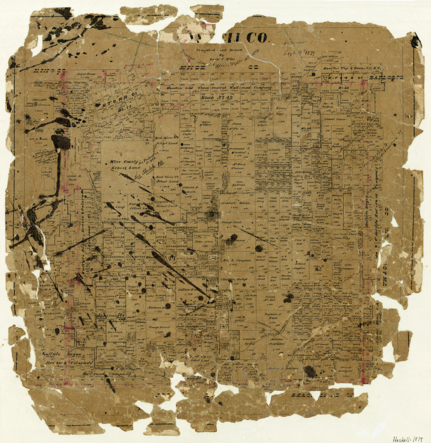
Haskell County
-
Map/Doc
1127
-
Collection
General Map Collection
-
Object Dates
9/10/1879 (Creation Date)
-
People and Organizations
Louis C. Wise (Draftsman)
-
Counties
Haskell
-
Subjects
County
-
Height x Width
21.0 x 20.4 inches
53.3 x 51.8 cm
-
Features
Johnson's Lake
Lake Creek
Miller's Creek
Double Mountain Fork of Brazos River
Mulberry Creek
South Prong of Paint Creek
South Prong of California Creek
North Prong of Paint Creek
North Prong of Otey's Creek
California Road
Croton Creek
Kiowa Mountain
Louisa Mountain
Otey's Creek
California Creek
Haskell
Part of: General Map Collection
Cherokee County Working Sketch 26

Print $20.00
- Digital $50.00
Cherokee County Working Sketch 26
1977
Size 28.9 x 34.9 inches
Map/Doc 67981
Van Zandt County Sketch File 8

Print $10.00
- Digital $50.00
Van Zandt County Sketch File 8
1851
Size 9.7 x 7.9 inches
Map/Doc 39379
Rains County Sketch File 3

Print $8.00
- Digital $50.00
Rains County Sketch File 3
1849
Size 6.0 x 8.6 inches
Map/Doc 34947
Howard County Sketch File 2a

Print $20.00
- Digital $50.00
Howard County Sketch File 2a
1909
Size 32.8 x 25.6 inches
Map/Doc 11792
Coryell County Working Sketch 13

Print $20.00
- Digital $50.00
Coryell County Working Sketch 13
1950
Size 20.9 x 22.7 inches
Map/Doc 68220
Jefferson County Rolled Sketch 38

Print $20.00
- Digital $50.00
Jefferson County Rolled Sketch 38
1957
Size 33.8 x 31.5 inches
Map/Doc 6397
Pecos County Sketch File 29c

Print $14.00
- Digital $50.00
Pecos County Sketch File 29c
1929
Size 11.2 x 8.8 inches
Map/Doc 33698
Revised map of Jefferson County, Texas showing land surveys, railroads and water ways

Print $20.00
- Digital $50.00
Revised map of Jefferson County, Texas showing land surveys, railroads and water ways
1898
Size 27.2 x 24.1 inches
Map/Doc 95912
Map of the County of Cameron

Print $40.00
- Digital $50.00
Map of the County of Cameron
1884
Size 57.0 x 33.2 inches
Map/Doc 78646
Oldham County Working Sketch Graphic Index

Print $40.00
- Digital $50.00
Oldham County Working Sketch Graphic Index
1925
Size 42.2 x 51.7 inches
Map/Doc 76657
Henderson County Sketch File 9

Print $8.00
- Digital $50.00
Henderson County Sketch File 9
Size 8.3 x 7.8 inches
Map/Doc 26343
Nolan County Sketch File D1

Print $42.00
- Digital $50.00
Nolan County Sketch File D1
1904
Size 19.5 x 18.8 inches
Map/Doc 42173
You may also like
Flight Mission No. DAG-22K, Frame 84, Matagorda County

Print $20.00
- Digital $50.00
Flight Mission No. DAG-22K, Frame 84, Matagorda County
1953
Size 15.7 x 15.6 inches
Map/Doc 86468
Fayette County Boundary File 1

Print $2.00
- Digital $50.00
Fayette County Boundary File 1
Size 11.1 x 8.7 inches
Map/Doc 53330
Williamson County Rolled Sketch 10

Print $20.00
- Digital $50.00
Williamson County Rolled Sketch 10
1975
Size 24.8 x 19.2 inches
Map/Doc 8267
Outer Continental Shelf Leasing Maps (Louisiana Offshore Operations)

Print $20.00
- Digital $50.00
Outer Continental Shelf Leasing Maps (Louisiana Offshore Operations)
1959
Size 17.8 x 14.0 inches
Map/Doc 76100
Harris County Working Sketch 124

Print $20.00
- Digital $50.00
Harris County Working Sketch 124
1993
Size 30.0 x 34.0 inches
Map/Doc 66016
Lynn County Rolled Sketch 11

Print $20.00
- Digital $50.00
Lynn County Rolled Sketch 11
1940
Size 14.2 x 16.4 inches
Map/Doc 6647
Hudspeth County Sketch File 37

Print $80.00
- Digital $50.00
Hudspeth County Sketch File 37
Size 12.5 x 98.3 inches
Map/Doc 27008
Sutton County Rolled Sketch 36

Print $20.00
- Digital $50.00
Sutton County Rolled Sketch 36
1887
Size 27.3 x 33.4 inches
Map/Doc 7880
Hale County Sketch File 20

Print $6.00
- Digital $50.00
Hale County Sketch File 20
Size 15.7 x 10.5 inches
Map/Doc 24753
Map showing A. & N. W., Raymond Word #3, S.S. Hervey #496, and M. Farley #495 corrected to conform to the judgement in Cause #2888, Travis County District Court, State of Texas versus D. Sullivan, et al

Print $20.00
- Digital $50.00
Map showing A. & N. W., Raymond Word #3, S.S. Hervey #496, and M. Farley #495 corrected to conform to the judgement in Cause #2888, Travis County District Court, State of Texas versus D. Sullivan, et al
1915
Size 18.5 x 30.0 inches
Map/Doc 75812
Jefferson County Rolled Sketch 5

Print $20.00
- Digital $50.00
Jefferson County Rolled Sketch 5
1913
Size 47.0 x 40.7 inches
Map/Doc 9270
The Chief Justice County of Victoria. September 20, 1837

Print $20.00
The Chief Justice County of Victoria. September 20, 1837
2020
Size 23.3 x 21.7 inches
Map/Doc 96075