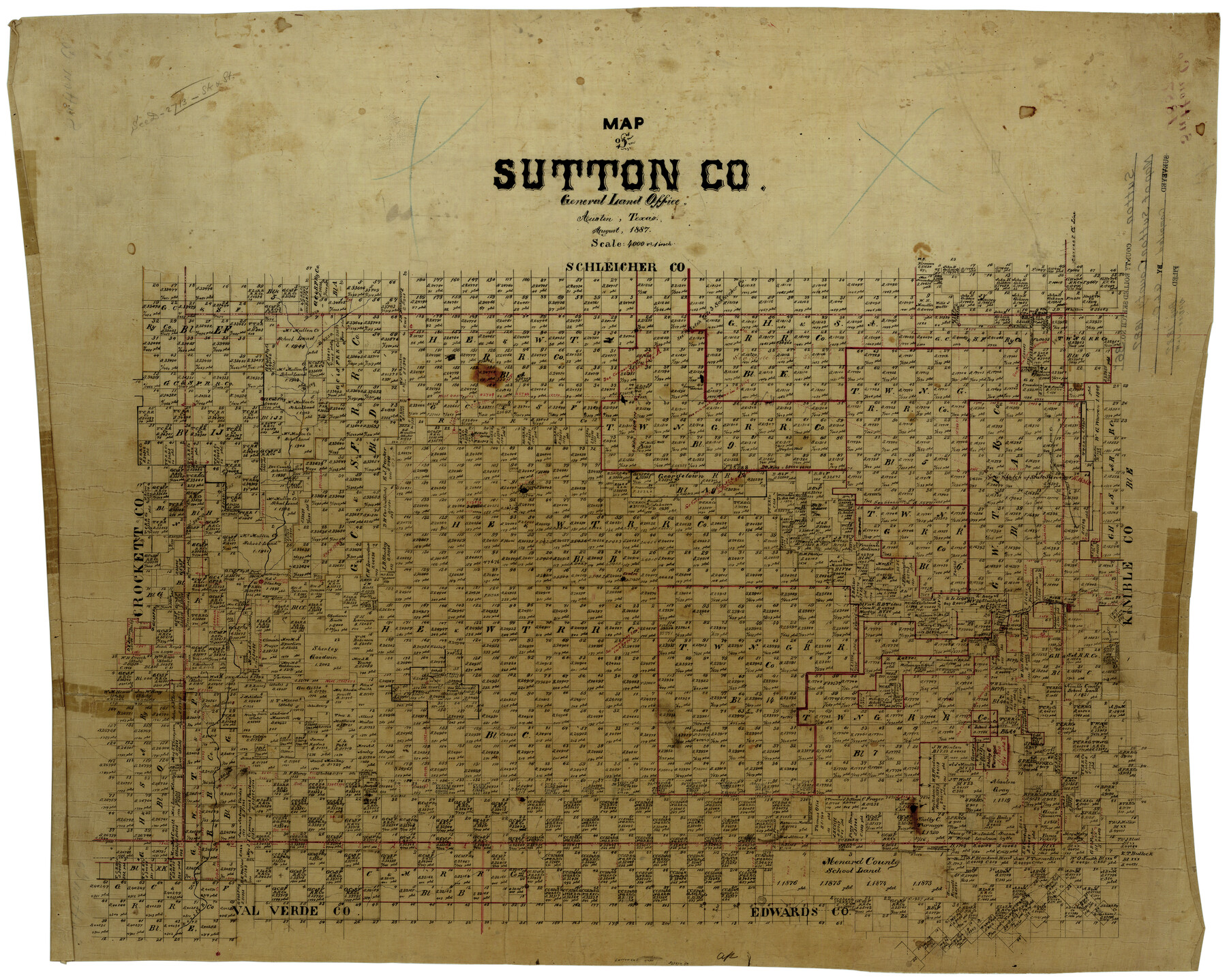
Sutton County Rolled Sketch 36
Map of Sutton Co.
-
Map/Doc
7880
-
Collection
General Map Collection
-
Object Dates
8/1887 (Creation Date)
-
Counties
Sutton
-
Subjects
Surveying Rolled Sketch
-
Height x Width
27.3 x 33.4 inches
69.3 x 84.8 cm
-
Medium
linen, manuscript
-
Scale
1" = 4000 varas
Part of: General Map Collection
Navarro County Sketch File 8

Print $4.00
- Digital $50.00
Navarro County Sketch File 8
1849
Size 13.2 x 8.5 inches
Map/Doc 32315
Harris County Working Sketch 13

Print $20.00
- Digital $50.00
Harris County Working Sketch 13
1915
Size 19.9 x 11.0 inches
Map/Doc 65905
Flight Mission No. BRA-6M, Frame 153, Jefferson County

Print $20.00
- Digital $50.00
Flight Mission No. BRA-6M, Frame 153, Jefferson County
1953
Size 18.5 x 22.2 inches
Map/Doc 85454
Gray County Sketch File 11

Print $40.00
- Digital $50.00
Gray County Sketch File 11
Size 15.0 x 13.5 inches
Map/Doc 24452
Old Miscellaneous File 19

Print $32.00
- Digital $50.00
Old Miscellaneous File 19
Size 14.2 x 8.8 inches
Map/Doc 75499
Sherman County Sketch File 6

Print $2.00
- Digital $50.00
Sherman County Sketch File 6
1993
Size 14.6 x 9.1 inches
Map/Doc 36724

Harris County Working Sketch 128

Print $20.00
- Digital $50.00
Harris County Working Sketch 128
1996
Size 15.0 x 14.0 inches
Map/Doc 66020
Flight Mission No. DCL-4C, Frame 69, Kenedy County

Print $20.00
- Digital $50.00
Flight Mission No. DCL-4C, Frame 69, Kenedy County
1943
Size 18.7 x 22.3 inches
Map/Doc 85814
Wilbarger County Sketch File 22

Print $4.00
- Digital $50.00
Wilbarger County Sketch File 22
1889
Size 9.7 x 6.2 inches
Map/Doc 40221
Harris County Sketch File 61

Print $20.00
- Digital $50.00
Harris County Sketch File 61
1927
Size 19.4 x 16.7 inches
Map/Doc 11659
Hood County Working Sketch 21

Print $20.00
- Digital $50.00
Hood County Working Sketch 21
1991
Size 28.4 x 24.9 inches
Map/Doc 66215
You may also like

Wilson Empresario Colony. May 27, 1826

Print $20.00
Wilson Empresario Colony. May 27, 1826
2020
Size 19.4 x 21.6 inches
Map/Doc 96010
Portions of Galveston and East Bays and the Gulf of Mexico in Galveston County, showing Subdivision for Mineral Development

Print $20.00
- Digital $50.00
Portions of Galveston and East Bays and the Gulf of Mexico in Galveston County, showing Subdivision for Mineral Development
1978
Size 38.1 x 25.8 inches
Map/Doc 1904
Floyd County Rolled Sketch V

Print $35.00
- Digital $50.00
Floyd County Rolled Sketch V
1918
Size 11.2 x 8.8 inches
Map/Doc 44548
Presidio County

Print $40.00
- Digital $50.00
Presidio County
1875
Size 97.8 x 33.5 inches
Map/Doc 88867
Dimmit County Sketch File 1

Print $42.00
- Digital $50.00
Dimmit County Sketch File 1
1851
Size 8.8 x 7.5 inches
Map/Doc 21050
Brooks County Working Sketch 4

Print $20.00
- Digital $50.00
Brooks County Working Sketch 4
1906
Size 28.6 x 24.9 inches
Map/Doc 67788

Atascosa County Working Sketch 36

Print $20.00
- Digital $50.00
Atascosa County Working Sketch 36
2008
Size 29.4 x 44.5 inches
Map/Doc 88878
San Jacinto River and Tributaries, Texas - Survey of 1939

Print $20.00
- Digital $50.00
San Jacinto River and Tributaries, Texas - Survey of 1939
1939
Size 28.0 x 40.3 inches
Map/Doc 60307
[Sketch for Mineral Application 35811 - Liberty County, John Mecom]
![65619, [Sketch for Mineral Application 35811 - Liberty County, John Mecom], General Map Collection](https://historictexasmaps.com/wmedia_w700/maps/65619.tif.jpg)
Print $4.00
- Digital $50.00
[Sketch for Mineral Application 35811 - Liberty County, John Mecom]
1941
Size 24.9 x 20.0 inches
Map/Doc 65619
La Salle County Working Sketch 22

Print $20.00
- Digital $50.00
La Salle County Working Sketch 22
1942
Size 36.2 x 29.2 inches
Map/Doc 70323