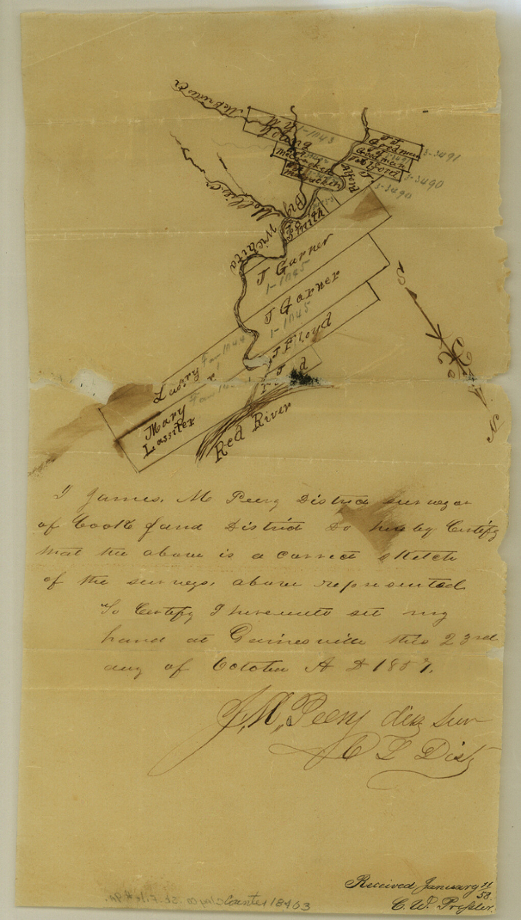
Clay County Sketch File 9a
[Sketches of surveys and area near the Red River near the mouth of the Big Wichita]
-
Map/Doc
18403
-
Collection
General Map Collection
-
Object Dates
1855/10/25 (Creation Date)
1857/10/23 (Creation Date)
1858/1/11 (File Date)
-
People and Organizations
Daniel Montague (Surveyor/Engineer)
James M. Peery (Surveyor/Engineer)
-
Counties
Clay
-
Subjects
Surveying Sketch File
-
Height x Width
10.7 x 6.1 inches
27.2 x 15.5 cm
-
Medium
paper, manuscript
-
Features
Big Wichita River
McBrides Creek
Red River
Part of: General Map Collection
[Sketch for Mineral Application 27669 - Trinity River, Frank R. Graves]
![2861, [Sketch for Mineral Application 27669 - Trinity River, Frank R. Graves], General Map Collection](https://historictexasmaps.com/wmedia_w700/maps/2861-1.tif.jpg)
Print $40.00
- Digital $50.00
[Sketch for Mineral Application 27669 - Trinity River, Frank R. Graves]
1934
Size 27.4 x 61.6 inches
Map/Doc 2861

Tom Green County Sketch File 31

Print $40.00
- Digital $50.00
Tom Green County Sketch File 31
Size 14.2 x 13.4 inches
Map/Doc 38190
Railroad Track Map, T&PRRCo., Culberson County, Texas

Print $4.00
- Digital $50.00
Railroad Track Map, T&PRRCo., Culberson County, Texas
1910
Size 11.7 x 18.5 inches
Map/Doc 62825
Palo Pinto County Working Sketch 23

Print $40.00
- Digital $50.00
Palo Pinto County Working Sketch 23
1985
Map/Doc 71406
Val Verde County Rolled Sketch 42

Print $20.00
- Digital $50.00
Val Verde County Rolled Sketch 42
1919
Size 17.3 x 21.9 inches
Map/Doc 8116
Montgomery County Rolled Sketch 42

Print $20.00
- Digital $50.00
Montgomery County Rolled Sketch 42
1939
Size 14.1 x 20.3 inches
Map/Doc 6815
Polk County Working Sketch 9

Print $20.00
- Digital $50.00
Polk County Working Sketch 9
1934
Size 22.7 x 30.8 inches
Map/Doc 71624
Presidio County Working Sketch 137

Print $20.00
- Digital $50.00
Presidio County Working Sketch 137
1990
Size 24.1 x 42.8 inches
Map/Doc 71815
Hood County Sketch File 9

Print $26.00
- Digital $50.00
Hood County Sketch File 9
1859
Size 9.6 x 4.5 inches
Map/Doc 26586
Flight Mission No. BRA-9M, Frame 69, Jefferson County

Print $20.00
- Digital $50.00
Flight Mission No. BRA-9M, Frame 69, Jefferson County
1953
Size 18.5 x 22.3 inches
Map/Doc 85652
Palo Pinto County Working Sketch 22

Print $20.00
- Digital $50.00
Palo Pinto County Working Sketch 22
1985
Map/Doc 71405
You may also like
Map of T. C. Spearman's Lands in Gaines, Terry and Yoakum Counties, Texas

Print $3.00
- Digital $50.00
Map of T. C. Spearman's Lands in Gaines, Terry and Yoakum Counties, Texas
1917
Size 12.4 x 10.2 inches
Map/Doc 92002
Carte de la Louisiane et du Cours du Mississipi

Print $20.00
Carte de la Louisiane et du Cours du Mississipi
1718
Size 16.6 x 21.8 inches
Map/Doc 89216
Clay County Boundary File 15

Print $8.00
- Digital $50.00
Clay County Boundary File 15
Size 13.3 x 8.2 inches
Map/Doc 51418
[Portion of Harris County]
![78481, [Portion of Harris County], General Map Collection](https://historictexasmaps.com/wmedia_w700/maps/78481.tif.jpg)
Print $2.00
- Digital $50.00
[Portion of Harris County]
Size 7.9 x 5.1 inches
Map/Doc 78481
Edwards County Working Sketch 132

Print $20.00
- Digital $50.00
Edwards County Working Sketch 132
1985
Size 37.1 x 37.1 inches
Map/Doc 69008
Tyler County Sketch File 21

Print $4.00
- Digital $50.00
Tyler County Sketch File 21
1906
Size 10.9 x 9.1 inches
Map/Doc 38677
Kaufman County Sketch File 17

Print $4.00
- Digital $50.00
Kaufman County Sketch File 17
1873
Size 8.0 x 6.1 inches
Map/Doc 28657
Wichita County Working Sketch 5

Print $20.00
- Digital $50.00
Wichita County Working Sketch 5
1913
Size 18.2 x 27.0 inches
Map/Doc 72514
[Right of Way and Track Map, the Missouri, Kansas and Texas Ry. of Texas - Henrietta Division]
![64757, [Right of Way and Track Map, the Missouri, Kansas and Texas Ry. of Texas - Henrietta Division], General Map Collection](https://historictexasmaps.com/wmedia_w700/maps/64757.tif.jpg)
Print $20.00
- Digital $50.00
[Right of Way and Track Map, the Missouri, Kansas and Texas Ry. of Texas - Henrietta Division]
1918
Size 11.8 x 26.9 inches
Map/Doc 64757
Ward County Working Sketch 22

Print $20.00
- Digital $50.00
Ward County Working Sketch 22
1953
Size 19.5 x 20.7 inches
Map/Doc 72328
Culberson County Working Sketch 9

Print $20.00
- Digital $50.00
Culberson County Working Sketch 9
1915
Size 41.5 x 35.9 inches
Map/Doc 68461
Flight Mission No. BRA-16M, Frame 116, Jefferson County

Print $20.00
- Digital $50.00
Flight Mission No. BRA-16M, Frame 116, Jefferson County
1953
Size 18.5 x 22.3 inches
Map/Doc 85726