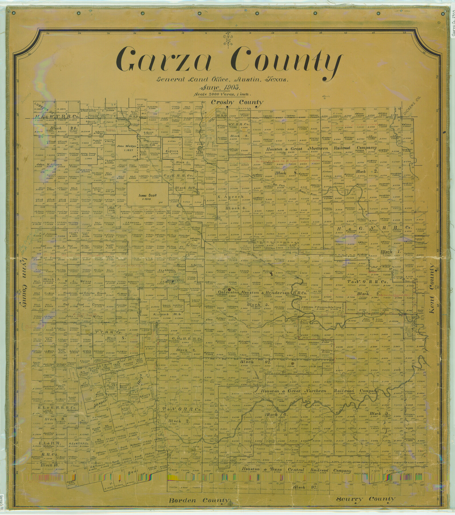
Garza County
-
Map/Doc
4704
-
Collection
General Map Collection
-
Object Dates
1903 (Creation Date)
-
People and Organizations
Texas General Land Office (Publisher)
Morris (Draftsman)
Morris (Compiler)
-
Counties
Garza
-
Subjects
County
-
Height x Width
42.2 x 37.3 inches
107.2 x 94.7 cm
-
Comments
Help Save Texas History - Adopt Me!
-
Features
Gobler [sic] Creek
Salt Spring
Bottle Corner
Brazos River
Coopers Branch of Double Mountain Fork of Brazos River
Double Mountain Fork of Brazos River
Sandy Creek
Rocky Creek
Little Grape Creek
Big Grape Creek
Duffy's Peak
Sand Creek
Tee Pee Creek
Post City
Yellow House River
Alamo River
Cat Fish Creek
White River
Salt Fork of Brazos River
Part of: General Map Collection
Knox County Sketch File 9

Print $4.00
- Digital $50.00
Knox County Sketch File 9
1889
Size 11.1 x 8.8 inches
Map/Doc 29221
San Patricio County Rolled Sketch 37

Print $127.00
- Digital $50.00
San Patricio County Rolled Sketch 37
Size 10.3 x 15.2 inches
Map/Doc 48888
Coryell County Sketch File 20

Print $20.00
- Digital $50.00
Coryell County Sketch File 20
Size 25.8 x 20.1 inches
Map/Doc 11183
Southern Part of Laguna Madre

Print $20.00
- Digital $50.00
Southern Part of Laguna Madre
1966
Size 44.3 x 34.8 inches
Map/Doc 73540
Harris County Historic Topographic 18

Print $20.00
- Digital $50.00
Harris County Historic Topographic 18
1916
Size 29.4 x 23.0 inches
Map/Doc 65828

Galveston County Sketch File 15

Print $4.00
- Digital $50.00
Galveston County Sketch File 15
Size 6.7 x 3.7 inches
Map/Doc 23382
Mason County Working Sketch 5

Print $20.00
- Digital $50.00
Mason County Working Sketch 5
1935
Size 12.1 x 18.5 inches
Map/Doc 70841
Coast Chart No. 212 - From Latitude 26° 33' to the Rio Grande Texas

Print $20.00
- Digital $50.00
Coast Chart No. 212 - From Latitude 26° 33' to the Rio Grande Texas
1886
Size 27.4 x 18.2 inches
Map/Doc 72829
Lynn County Rolled Sketch S

Print $20.00
- Digital $50.00
Lynn County Rolled Sketch S
Size 21.1 x 38.7 inches
Map/Doc 6654
San Augustine County Sketch File 1

Print $4.00
San Augustine County Sketch File 1
1849
Size 9.3 x 8.2 inches
Map/Doc 35631
Runnels County Rolled Sketch 46

Print $20.00
- Digital $50.00
Runnels County Rolled Sketch 46
1954
Size 32.3 x 38.5 inches
Map/Doc 10622
You may also like

Origins of Imports and Destination of Exports at Houston, Tex., during 1921

Print $20.00
- Digital $50.00
Origins of Imports and Destination of Exports at Houston, Tex., during 1921
1921
Size 14.2 x 23.1 inches
Map/Doc 97171
[Blks A, B and C, and Irion, Floyd, Sutton and Lubbock County School Land Leagues]
![90202, [Blks A, B and C, and Irion, Floyd, Sutton and Lubbock County School Land Leagues], Twichell Survey Records](https://historictexasmaps.com/wmedia_w700/maps/90202-1.tif.jpg)
Print $20.00
- Digital $50.00
[Blks A, B and C, and Irion, Floyd, Sutton and Lubbock County School Land Leagues]
Size 15.6 x 19.2 inches
Map/Doc 90202
Galveston Bay and Approaches

Print $20.00
- Digital $50.00
Galveston Bay and Approaches
1961
Size 46.2 x 34.1 inches
Map/Doc 69878
Flight Mission No. DQN-7K, Frame 5, Calhoun County

Print $20.00
- Digital $50.00
Flight Mission No. DQN-7K, Frame 5, Calhoun County
1953
Size 18.5 x 19.1 inches
Map/Doc 84456
General Highway Map, Tom Green County, Texas

Print $20.00
General Highway Map, Tom Green County, Texas
1940
Size 25.0 x 18.5 inches
Map/Doc 79260
From Citizens Living in Gonzales and Victoria Counties for the Creation of a New Judicial County to be Called Guadalupe, Undated

Print $20.00
From Citizens Living in Gonzales and Victoria Counties for the Creation of a New Judicial County to be Called Guadalupe, Undated
2020
Size 24.5 x 21.7 inches
Map/Doc 96413
![92619, [Hart Townsite], Twichell Survey Records](https://historictexasmaps.com/wmedia_w700/maps/92619-1.tif.jpg)
Blanco County Sketch File 41

Print $6.00
- Digital $50.00
Blanco County Sketch File 41
Size 9.6 x 14.3 inches
Map/Doc 14654
Donley County Working Sketch 5

Print $40.00
- Digital $50.00
Donley County Working Sketch 5
1957
Size 54.8 x 32.2 inches
Map/Doc 62185
Dawson County Rolled Sketch 5

Print $20.00
- Digital $50.00
Dawson County Rolled Sketch 5
1913
Size 33.6 x 28.0 inches
Map/Doc 5691
Intracoastal Waterway, Houma, LA to Corpus Christi, TX

Print $5.00
- Digital $50.00
Intracoastal Waterway, Houma, LA to Corpus Christi, TX
Size 29.3 x 22.0 inches
Map/Doc 61909