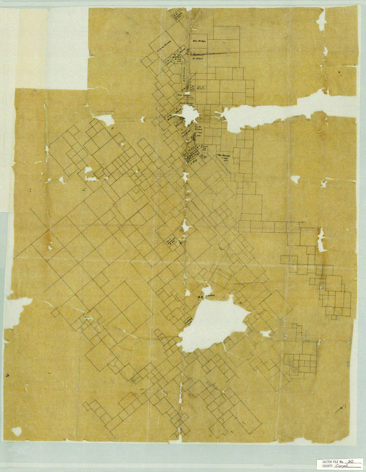
Coryell County Sketch File 20
[Skeleton sketch of surveys in the northern part of the county and adjacent counties]
-
Map/Doc
11183
-
Collection
General Map Collection
-
Counties
Coryell Hamilton Bosque
-
Subjects
Surveying Sketch File
-
Height x Width
25.8 x 20.1 inches
65.5 x 51.1 cm
-
Medium
paper, manuscript
Part of: General Map Collection
United States, 1956 Revised Edition

Print $40.00
- Digital $50.00
United States, 1956 Revised Edition
1946
Size 48.0 x 36.3 inches
Map/Doc 78631
Wilson County Working Sketch 1

Print $2.00
- Digital $50.00
Wilson County Working Sketch 1
Size 7.1 x 13.1 inches
Map/Doc 72581
Foard County Boundary File 1

Print $8.00
- Digital $50.00
Foard County Boundary File 1
Size 9.1 x 4.1 inches
Map/Doc 53500
Garza County Sketch File D

Print $20.00
- Digital $50.00
Garza County Sketch File D
1901
Size 18.4 x 12.2 inches
Map/Doc 11550
Gray County Boundary File 9

Print $6.00
- Digital $50.00
Gray County Boundary File 9
Size 11.6 x 9.1 inches
Map/Doc 53902
[Right of Way & Track Map, The Texas & Pacific Ry. Co. Main Line]
![64674, [Right of Way & Track Map, The Texas & Pacific Ry. Co. Main Line], General Map Collection](https://historictexasmaps.com/wmedia_w700/maps/64674.tif.jpg)
Print $20.00
- Digital $50.00
[Right of Way & Track Map, The Texas & Pacific Ry. Co. Main Line]
Size 11.1 x 18.6 inches
Map/Doc 64674
Jefferson County Working Sketch 16

Print $20.00
- Digital $50.00
Jefferson County Working Sketch 16
1954
Size 31.0 x 18.8 inches
Map/Doc 66559
Brewster County Rolled Sketch 101

Print $20.00
- Digital $50.00
Brewster County Rolled Sketch 101
1944
Size 34.6 x 42.4 inches
Map/Doc 8924
Flight Mission No. CRC-4R, Frame 161, Chambers County

Print $20.00
- Digital $50.00
Flight Mission No. CRC-4R, Frame 161, Chambers County
1956
Size 18.5 x 22.3 inches
Map/Doc 84920
Flight Mission No. DAG-21K, Frame 84, Matagorda County

Print $20.00
- Digital $50.00
Flight Mission No. DAG-21K, Frame 84, Matagorda County
1952
Size 18.6 x 22.3 inches
Map/Doc 86413
Midland County Working Sketch 6

Print $20.00
- Digital $50.00
Midland County Working Sketch 6
1950
Size 41.2 x 30.9 inches
Map/Doc 70986
Jeff Davis County Rolled Sketch 6

Print $20.00
- Digital $50.00
Jeff Davis County Rolled Sketch 6
1889
Size 41.3 x 26.4 inches
Map/Doc 6360
You may also like
Harris County Rolled Sketch 87A

Print $20.00
- Digital $50.00
Harris County Rolled Sketch 87A
Size 41.1 x 47.6 inches
Map/Doc 78250
Flight Mission No. CLL-1N, Frame 17, Willacy County

Print $20.00
- Digital $50.00
Flight Mission No. CLL-1N, Frame 17, Willacy County
1954
Size 18.5 x 22.1 inches
Map/Doc 87004
Map of Travis County

Print $40.00
- Digital $50.00
Map of Travis County
1895
Size 48.8 x 54.1 inches
Map/Doc 82083
Starr County Sketch File 49

Print $20.00
- Digital $50.00
Starr County Sketch File 49
1951
Size 24.9 x 17.2 inches
Map/Doc 12346
Roberts County School Lands, Bailey County, Texas

Print $2.00
- Digital $50.00
Roberts County School Lands, Bailey County, Texas
1918
Size 8.8 x 11.3 inches
Map/Doc 90199
Jackson County Working Sketch 10

Print $20.00
- Digital $50.00
Jackson County Working Sketch 10
1991
Size 35.9 x 36.1 inches
Map/Doc 66458
Map of Navarro County

Print $20.00
- Digital $50.00
Map of Navarro County
1872
Size 19.4 x 25.5 inches
Map/Doc 3910

Jackson County Sketch File 17

Print $20.00
- Digital $50.00
Jackson County Sketch File 17
1913
Size 19.4 x 19.1 inches
Map/Doc 11841
Recharge zone of the Edwards Aquifer hydrologically associated with Barton Springs in the Austin Area, Texas

Print $20.00
- Digital $50.00
Recharge zone of the Edwards Aquifer hydrologically associated with Barton Springs in the Austin Area, Texas
1986
Size 41.5 x 29.3 inches
Map/Doc 60400
[Floyd County Schoo Land Lgs. 180-183, Fisher County School Land Lgs. 105-108, and part of Blk. V]
![90190, [Floyd County Schoo Land Lgs. 180-183, Fisher County School Land Lgs. 105-108, and part of Blk. V], Twichell Survey Records](https://historictexasmaps.com/wmedia_w700/maps/90190-1.tif.jpg)
Print $2.00
- Digital $50.00
[Floyd County Schoo Land Lgs. 180-183, Fisher County School Land Lgs. 105-108, and part of Blk. V]
Size 8.8 x 10.2 inches
Map/Doc 90190
Glasscock County Sketch File 3

Print $3.00
- Digital $50.00
Glasscock County Sketch File 3
1931
Size 11.1 x 14.8 inches
Map/Doc 11560