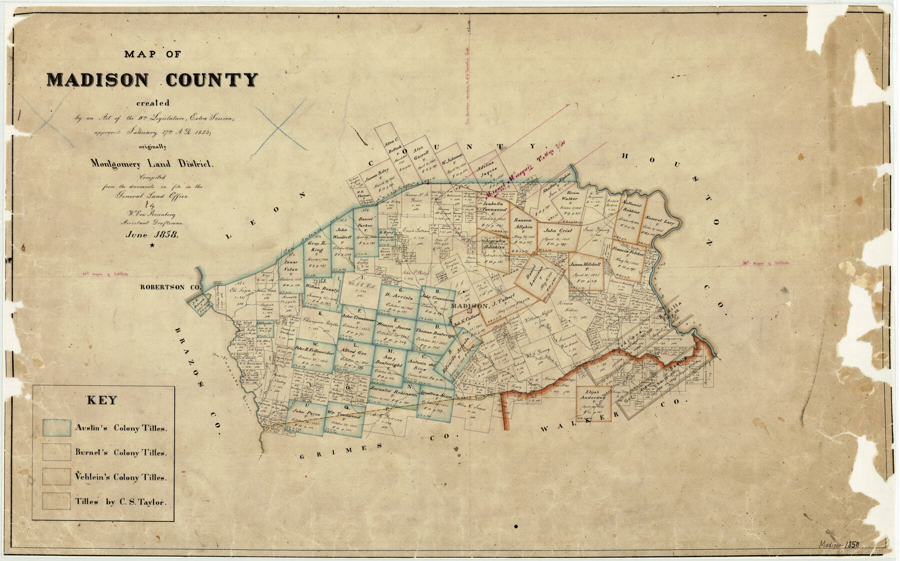
Map of Madison County
-
Map/Doc
3834
-
Collection
General Map Collection
-
Object Dates
6/1858 (Creation Date)
-
People and Organizations
Texas General Land Office (Publisher)
W. von Rosenberg (Compiler)
-
Counties
Madison
-
Subjects
County
-
Height x Width
19.8 x 31.7 inches
50.3 x 80.5 cm
-
Comments
Originally Montgomery Land District.
-
Features
Caney Creek
South Bidais Creek
Prewitt's Creek
Navasoto [sic] River
Shephard's Creek
Collard's Creek
Bidais Creek
Pool's Creek
Madison
Nacogdoches Road
San Antonio and Nacogdoches Road
San Antonio Road
Brushy Creek
Larrison Creek
York's Creek
Trinity River
Robbin's Ferry
Part of: General Map Collection
Township No. 5 South, Range No. 13 West, Indian Meridian, Oklahoma

Print $4.00
- Digital $50.00
Township No. 5 South, Range No. 13 West, Indian Meridian, Oklahoma
1928
Size 17.9 x 23.0 inches
Map/Doc 75142
Lavaca County Rolled Sketch 5

Print $40.00
- Digital $50.00
Lavaca County Rolled Sketch 5
Size 37.0 x 49.1 inches
Map/Doc 10288
Flight Mission No. BRE-2P, Frame 25, Nueces County

Print $20.00
- Digital $50.00
Flight Mission No. BRE-2P, Frame 25, Nueces County
1956
Size 18.4 x 22.2 inches
Map/Doc 86734
Hardin County Sketch File 39 and 40

Print $36.00
- Digital $50.00
Hardin County Sketch File 39 and 40
Size 8.4 x 13.2 inches
Map/Doc 25180
Morris County Rolled Sketch 2A

Print $20.00
- Digital $50.00
Morris County Rolled Sketch 2A
Size 24.0 x 18.8 inches
Map/Doc 10228
Houston County Sketch File 30

Print $4.00
- Digital $50.00
Houston County Sketch File 30
1895
Size 8.3 x 7.1 inches
Map/Doc 26806
Dawson County Working Sketch 13

Print $20.00
- Digital $50.00
Dawson County Working Sketch 13
1952
Size 18.1 x 12.6 inches
Map/Doc 68557
Red River County Working Sketch 77

Print $20.00
- Digital $50.00
Red River County Working Sketch 77
1981
Size 34.9 x 23.8 inches
Map/Doc 72060
Hemphill County Working Sketch 17

Print $20.00
- Digital $50.00
Hemphill County Working Sketch 17
1972
Size 33.6 x 45.0 inches
Map/Doc 66112
Copy of Surveyor's Field Book, Morris Browning - In Blocks 7, 5 & 4, I&GNRRCo., Hutchinson and Carson Counties, Texas

Print $2.00
- Digital $50.00
Copy of Surveyor's Field Book, Morris Browning - In Blocks 7, 5 & 4, I&GNRRCo., Hutchinson and Carson Counties, Texas
1888
Size 7.0 x 8.8 inches
Map/Doc 62276
Knox County Rolled Sketch 26

Print $20.00
- Digital $50.00
Knox County Rolled Sketch 26
2007
Size 36.8 x 24.7 inches
Map/Doc 88822
Lee County Working Sketch 8

Print $20.00
- Digital $50.00
Lee County Working Sketch 8
1979
Size 27.8 x 37.1 inches
Map/Doc 70387
You may also like
"Old Three Hundred" Land Grants under Austin's First Contract

"Old Three Hundred" Land Grants under Austin's First Contract
2023
Size 8.5 x 11.0 inches
Map/Doc 97185
Eastland County Working Sketch 37

Print $20.00
- Digital $50.00
Eastland County Working Sketch 37
1967
Size 23.7 x 18.1 inches
Map/Doc 68818
Harris County Working Sketch 21

Print $20.00
- Digital $50.00
Harris County Working Sketch 21
Size 14.1 x 22.6 inches
Map/Doc 65913
Brown County Sketch File 10a

Print $6.00
- Digital $50.00
Brown County Sketch File 10a
Size 11.2 x 9.8 inches
Map/Doc 16595
Sutton County Sketch File 7

Print $4.00
- Digital $50.00
Sutton County Sketch File 7
Size 10.6 x 8.7 inches
Map/Doc 37365
South Montgomery County, Woodlands Chamber of Commerce Street Map

South Montgomery County, Woodlands Chamber of Commerce Street Map
Size 50.0 x 37.9 inches
Map/Doc 94363
San Antonio of the 17th, 18th, and 19th Centuries: A Chronology of Her Romantic Past

San Antonio of the 17th, 18th, and 19th Centuries: A Chronology of Her Romantic Past
1929
Size 8.1 x 5.1 inches
Map/Doc 97044
Right of Way & Track Map, St. Louis, Brownsville & Mexico Ry. operated by St. Louis, Brownsville & Mexico Ry. Co.

Print $40.00
- Digital $50.00
Right of Way & Track Map, St. Louis, Brownsville & Mexico Ry. operated by St. Louis, Brownsville & Mexico Ry. Co.
1919
Size 25.8 x 56.9 inches
Map/Doc 64620
Bell County Working Sketch 19

Print $40.00
- Digital $50.00
Bell County Working Sketch 19
1994
Size 48.3 x 38.4 inches
Map/Doc 67359
Working Sketch in Archer County

Print $20.00
- Digital $50.00
Working Sketch in Archer County
1924
Size 30.7 x 42.4 inches
Map/Doc 89980
Hudspeth County Working Sketch 17

Print $40.00
- Digital $50.00
Hudspeth County Working Sketch 17
1957
Size 22.6 x 112.4 inches
Map/Doc 66299
