Sterling County Rolled Sketch 10
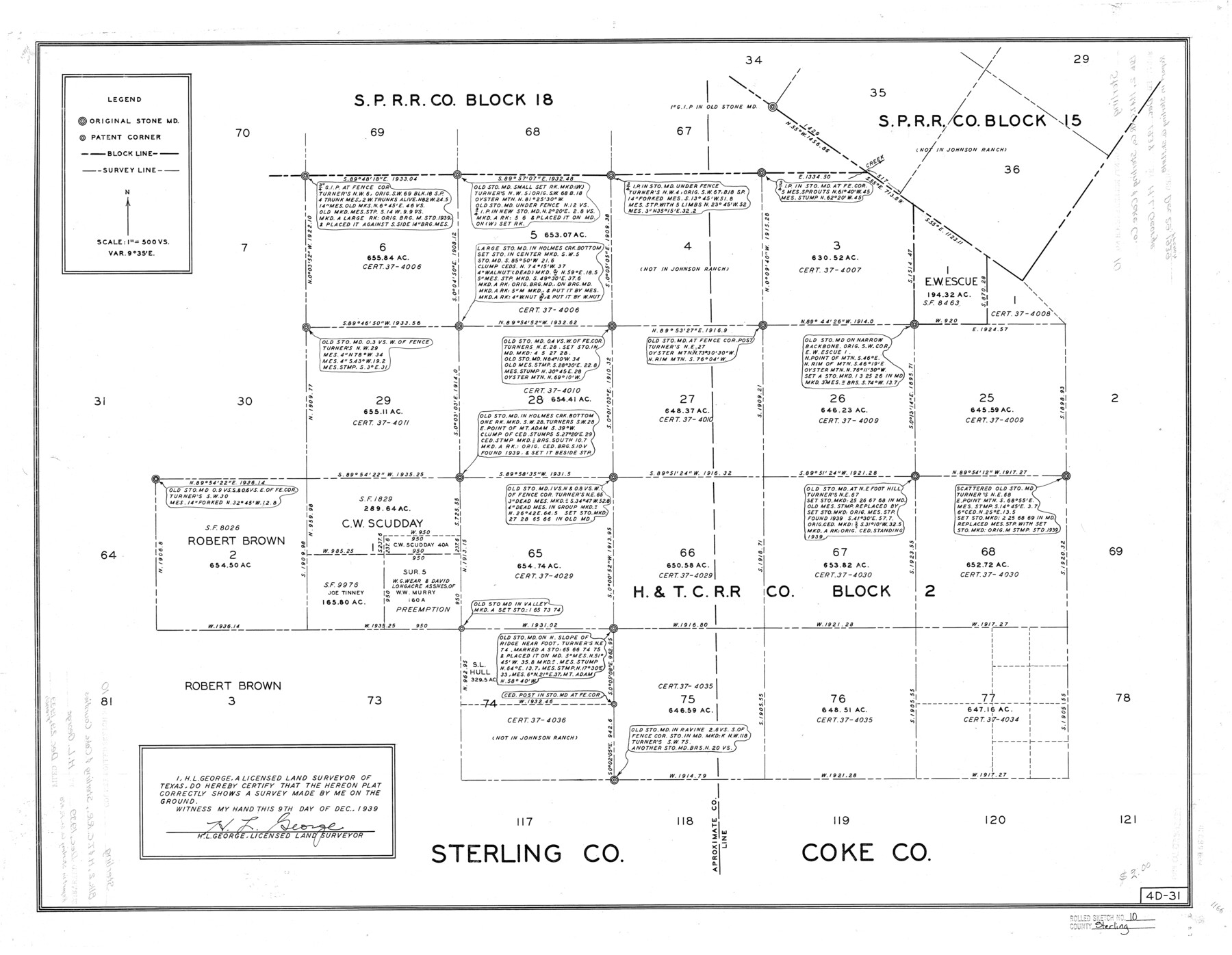
[Sketch of part of Block 2, H. & T. C. R.R. Co. in Sterling and Coke Counties]
-
Map/Doc
7846
-
Collection
General Map Collection
-
Object Dates
1939/12/9 (Creation Date)
1939/12/29 (File Date)
-
People and Organizations
H.L. George (Surveyor/Engineer)
-
Counties
Sterling Coke
-
Subjects
Surveying Rolled Sketch
-
Height x Width
24.2 x 31.2 inches
61.5 x 79.2 cm
-
Scale
1" = 500 varas
Part of: General Map Collection
Chipman's Map of Briscoe, Hall, Motley, Cottle Counties

Print $40.00
- Digital $50.00
Chipman's Map of Briscoe, Hall, Motley, Cottle Counties
1911
Size 54.7 x 92.6 inches
Map/Doc 2051
Dimmit County Sketch File 45

Print $20.00
- Digital $50.00
Dimmit County Sketch File 45
1905
Size 24.9 x 25.5 inches
Map/Doc 11355
Flight Mission No. DIX-10P, Frame 82, Aransas County

Print $20.00
- Digital $50.00
Flight Mission No. DIX-10P, Frame 82, Aransas County
1956
Size 18.8 x 22.4 inches
Map/Doc 83943
Denton County Rolled Sketch 2

Print $40.00
- Digital $50.00
Denton County Rolled Sketch 2
1933
Size 47.1 x 53.5 inches
Map/Doc 8338
Parker County

Print $20.00
- Digital $50.00
Parker County
1942
Size 45.7 x 37.8 inches
Map/Doc 66972
Dallam County Sketch File 2

Print $260.00
- Digital $50.00
Dallam County Sketch File 2
1886
Size 29.9 x 17.4 inches
Map/Doc 11278
Hunt County Rolled Sketch 5

Print $20.00
- Digital $50.00
Hunt County Rolled Sketch 5
1956
Size 22.9 x 23.0 inches
Map/Doc 6272
Sherman County

Print $20.00
- Digital $50.00
Sherman County
1889
Size 22.3 x 19.0 inches
Map/Doc 4036
Tom Green County Boundary File 87

Print $10.00
- Digital $50.00
Tom Green County Boundary File 87
Size 9.1 x 4.0 inches
Map/Doc 59393
Tarrant County

Print $20.00
- Digital $50.00
Tarrant County
1942
Size 46.5 x 37.1 inches
Map/Doc 77431
Pecos County Sketch File 31

Print $20.00
- Digital $50.00
Pecos County Sketch File 31
1931
Size 14.3 x 32.4 inches
Map/Doc 12173
Andrews County

Print $20.00
- Digital $50.00
Andrews County
1887
Size 22.8 x 25.8 inches
Map/Doc 3230
You may also like
Smith County Rolled Sketch 6D2

Print $2.00
- Digital $50.00
Smith County Rolled Sketch 6D2
Size 11.3 x 8.9 inches
Map/Doc 76014
Sterling County Rolled Sketch 27

Print $20.00
- Digital $50.00
Sterling County Rolled Sketch 27
Size 24.0 x 23.2 inches
Map/Doc 7852
La Salle County Sketch File 27

Print $22.00
- Digital $50.00
La Salle County Sketch File 27
Size 8.8 x 14.1 inches
Map/Doc 29553
R. S. Coon's Blue Creek Ranch, Moore County, Texas

Print $20.00
- Digital $50.00
R. S. Coon's Blue Creek Ranch, Moore County, Texas
Size 15.8 x 15.7 inches
Map/Doc 91487
Map of the City of Galveston, Texas

Print $40.00
- Digital $50.00
Map of the City of Galveston, Texas
1883
Size 37.2 x 66.3 inches
Map/Doc 96981
Taylor County

Print $20.00
- Digital $50.00
Taylor County
1934
Size 42.0 x 36.6 inches
Map/Doc 77432
Orange County Sketch File B

Print $20.00
- Digital $50.00
Orange County Sketch File B
1890
Size 17.6 x 26.0 inches
Map/Doc 12130
Reagan County Working Sketch 27

Print $20.00
- Digital $50.00
Reagan County Working Sketch 27
1960
Size 33.0 x 42.5 inches
Map/Doc 71869
Duval County Sketch File 34

Print $20.00
- Digital $50.00
Duval County Sketch File 34
Size 28.4 x 36.9 inches
Map/Doc 11391
La Salle County Sketch File 20

Print $34.00
- Digital $50.00
La Salle County Sketch File 20
1887
Size 13.6 x 8.7 inches
Map/Doc 29519
Brazoria County Working Sketch 47

Print $40.00
- Digital $50.00
Brazoria County Working Sketch 47
1988
Size 35.3 x 59.9 inches
Map/Doc 67532
Red River County Working Sketch 51

Print $20.00
- Digital $50.00
Red River County Working Sketch 51
1970
Size 31.2 x 28.5 inches
Map/Doc 72034