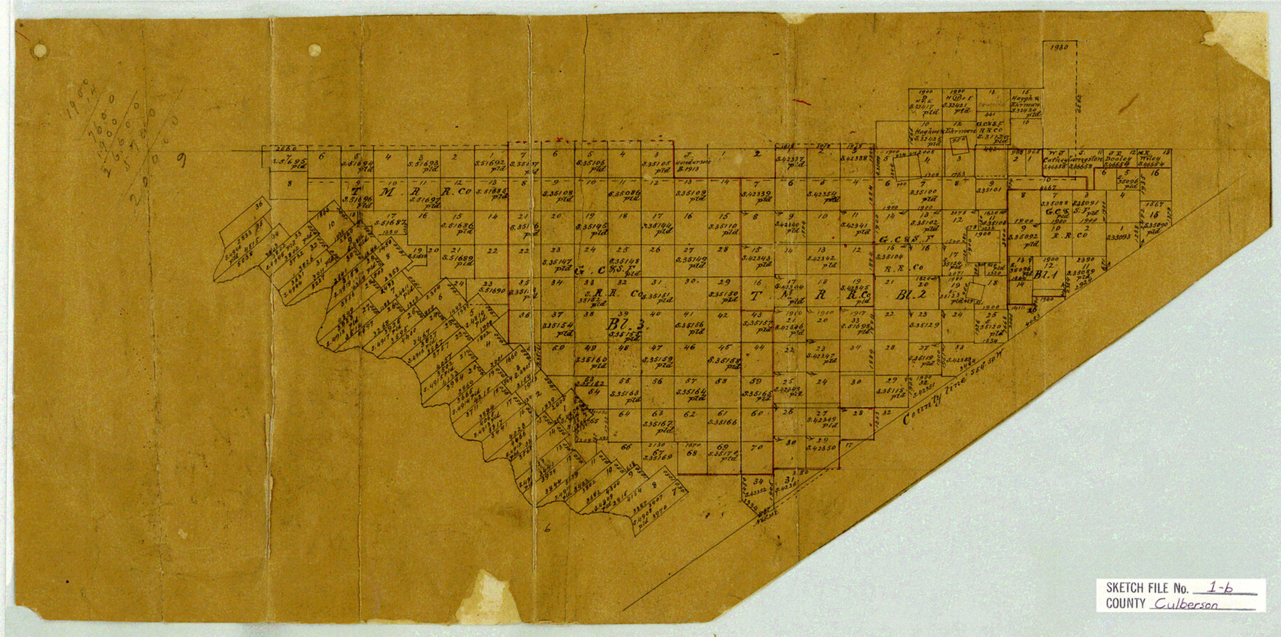
Culberson County Sketch File 1b
[Sketch of surveys in the south corner of the county]
-
Map/Doc
11260
-
Collection
General Map Collection
-
Counties
Culberson Hudspeth
-
Subjects
Surveying Sketch File
-
Height x Width
9.0 x 18.0 inches
22.9 x 45.7 cm
-
Medium
paper, manuscript
Part of: General Map Collection
Runnels County Rolled Sketch 28

Print $20.00
- Digital $50.00
Runnels County Rolled Sketch 28
1928
Size 19.8 x 39.4 inches
Map/Doc 7516
Andrews County Rolled Sketch 28

Print $20.00
- Digital $50.00
Andrews County Rolled Sketch 28
1948
Size 17.0 x 25.5 inches
Map/Doc 77172
Ector County Sketch File 2

Print $3.00
- Digital $50.00
Ector County Sketch File 2
1933
Size 19.4 x 16.1 inches
Map/Doc 11416
Flight Mission No. BRA-3M, Frame 192, Jefferson County

Print $20.00
- Digital $50.00
Flight Mission No. BRA-3M, Frame 192, Jefferson County
1953
Size 18.5 x 22.4 inches
Map/Doc 85407
Brazoria County Rolled Sketch 33

Print $133.00
- Digital $50.00
Brazoria County Rolled Sketch 33
Size 10.3 x 15.4 inches
Map/Doc 42960
Denton County Sketch File 14

Print $10.00
- Digital $50.00
Denton County Sketch File 14
1855
Size 8.6 x 10.0 inches
Map/Doc 20719
Frio County Sketch File 20

Print $6.00
- Digital $50.00
Frio County Sketch File 20
1964
Size 14.2 x 8.8 inches
Map/Doc 23159
Duval County Working Sketch 2

Print $20.00
- Digital $50.00
Duval County Working Sketch 2
1919
Size 16.4 x 15.0 inches
Map/Doc 76443
Morris County Rolled Sketch 2A

Print $20.00
- Digital $50.00
Morris County Rolled Sketch 2A
Size 24.0 x 18.7 inches
Map/Doc 10287
Kerr County Sketch File 15

Print $20.00
- Digital $50.00
Kerr County Sketch File 15
Size 23.7 x 16.8 inches
Map/Doc 11919
Concho County Sketch File 50

Print $20.00
- Digital $50.00
Concho County Sketch File 50
1890
Size 15.9 x 13.6 inches
Map/Doc 19217
Brown County Sketch File 26

Print $40.00
- Digital $50.00
Brown County Sketch File 26
Size 18.4 x 24.4 inches
Map/Doc 11023
You may also like
Harris County Rolled Sketch 101

Print $20.00
- Digital $50.00
Harris County Rolled Sketch 101
2004
Size 24.3 x 36.2 inches
Map/Doc 83063
Jack County Working Sketch Graphic Index

Print $20.00
- Digital $50.00
Jack County Working Sketch Graphic Index
1925
Size 45.4 x 37.3 inches
Map/Doc 76589
Flight Mission No. CRC-3R, Frame 43, Chambers County

Print $20.00
- Digital $50.00
Flight Mission No. CRC-3R, Frame 43, Chambers County
1956
Size 18.5 x 22.3 inches
Map/Doc 84816
Navarro County Working Sketch 7

Print $20.00
- Digital $50.00
Navarro County Working Sketch 7
1950
Size 28.2 x 23.4 inches
Map/Doc 71237
Controlled Mosaic by Jack Amman Photogrammetric Engineers, Inc - Sheet 4

Print $20.00
- Digital $50.00
Controlled Mosaic by Jack Amman Photogrammetric Engineers, Inc - Sheet 4
1954
Size 20.0 x 24.0 inches
Map/Doc 83448
Haskell County Rolled Sketch 11

Print $20.00
- Digital $50.00
Haskell County Rolled Sketch 11
1983
Size 23.0 x 28.0 inches
Map/Doc 6170
Survey plat of lots 2, 4, 6, 8, 10-16, Block 322 of the original town site of Jourdanton known as School File 154507

Print $4.00
- Digital $50.00
Survey plat of lots 2, 4, 6, 8, 10-16, Block 322 of the original town site of Jourdanton known as School File 154507
2001
Size 26.0 x 27.7 inches
Map/Doc 60392
Lampasas County Sketch File 11

Print $4.00
- Digital $50.00
Lampasas County Sketch File 11
1874
Size 12.2 x 7.9 inches
Map/Doc 29420
Travis County Sketch File 1

Print $4.00
- Digital $50.00
Travis County Sketch File 1
Size 16.1 x 12.7 inches
Map/Doc 38270
Aransas County NRC Article 33.136 Location Key Sheet

Print $20.00
- Digital $50.00
Aransas County NRC Article 33.136 Location Key Sheet
1970
Size 27.0 x 23.0 inches
Map/Doc 87904
Pecos County Rolled Sketch 81

Print $20.00
- Digital $50.00
Pecos County Rolled Sketch 81
1930
Size 35.9 x 25.4 inches
Map/Doc 7240
Webb County Working Sketch 70

Print $20.00
- Digital $50.00
Webb County Working Sketch 70
1971
Size 43.3 x 27.4 inches
Map/Doc 72437