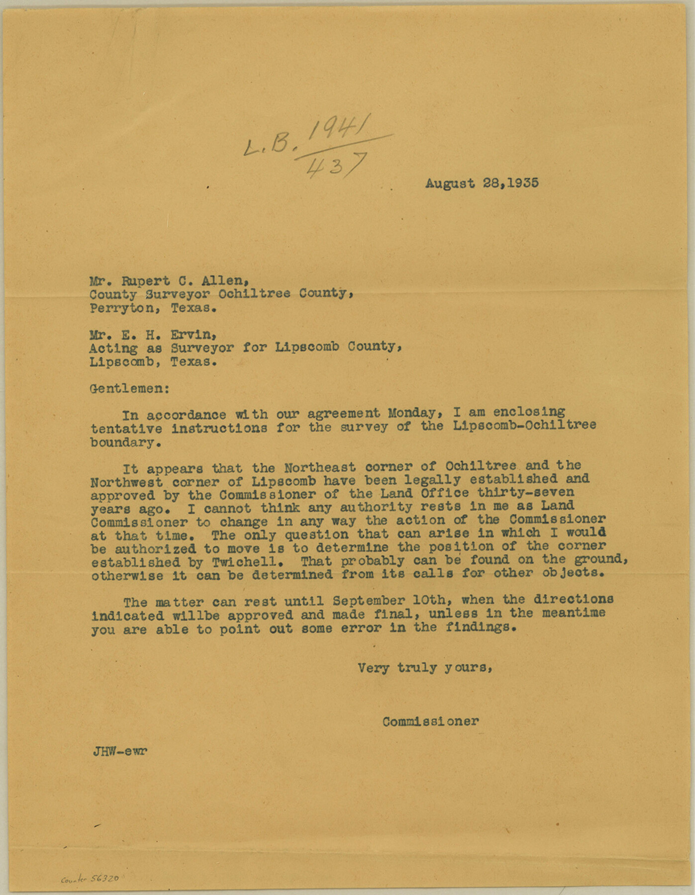
Lipscomb County Boundary File 4
Lipscomb-Ochiltree Line Copy of Tentative Instrustions [sp.] for locating Lipscomb-Ochiltree Line
-
Map/Doc
56320
-
Collection
General Map Collection
-
Counties
Lipscomb
-
Subjects
County Boundaries
-
Height x Width
11.1 x 8.6 inches
28.2 x 21.8 cm
Part of: General Map Collection
Calhoun County Rolled Sketch 32

Print $40.00
- Digital $50.00
Calhoun County Rolled Sketch 32
1978
Size 87.1 x 44.6 inches
Map/Doc 8560
Kleberg County Aerial Photograph Index Sheet 2

Print $20.00
- Digital $50.00
Kleberg County Aerial Photograph Index Sheet 2
1956
Size 19.4 x 23.4 inches
Map/Doc 83719
Kerr County Working Sketch 19

Print $20.00
- Digital $50.00
Kerr County Working Sketch 19
1959
Size 34.5 x 41.3 inches
Map/Doc 70050
Harris County Working Sketch 49

Print $20.00
- Digital $50.00
Harris County Working Sketch 49
1944
Size 28.7 x 33.9 inches
Map/Doc 65941
Flight Mission No. DQN-3K, Frame 5, Calhoun County

Print $20.00
- Digital $50.00
Flight Mission No. DQN-3K, Frame 5, Calhoun County
1953
Size 18.4 x 22.1 inches
Map/Doc 84337
Flight Mission No. DAG-26K, Frame 80, Matagorda County

Print $20.00
- Digital $50.00
Flight Mission No. DAG-26K, Frame 80, Matagorda County
1953
Size 18.5 x 22.3 inches
Map/Doc 86585
Armstrong County Boundary File 2

Print $8.00
- Digital $50.00
Armstrong County Boundary File 2
Size 14.1 x 8.7 inches
Map/Doc 50137
Terrell County Rolled Sketch 21

Print $20.00
- Digital $50.00
Terrell County Rolled Sketch 21
Size 19.1 x 27.7 inches
Map/Doc 7929
Crockett County Working Sketch 43

Print $20.00
- Digital $50.00
Crockett County Working Sketch 43
1931
Size 26.1 x 21.7 inches
Map/Doc 68376
Flight Mission No. DQO-2K, Frame 146, Galveston County

Print $20.00
- Digital $50.00
Flight Mission No. DQO-2K, Frame 146, Galveston County
1952
Size 18.7 x 22.4 inches
Map/Doc 85043
Williamson County Sketch File 16a

Print $4.00
- Digital $50.00
Williamson County Sketch File 16a
1870
Size 7.0 x 8.4 inches
Map/Doc 40336
Montgomery County Working Sketch 36

Print $20.00
- Digital $50.00
Montgomery County Working Sketch 36
1953
Size 34.6 x 34.5 inches
Map/Doc 71143
You may also like
Austin County Rolled Sketch 6

Print $20.00
- Digital $50.00
Austin County Rolled Sketch 6
1951
Size 25.5 x 34.0 inches
Map/Doc 5108
R. S. Dod Meanders

Print $20.00
- Digital $50.00
R. S. Dod Meanders
Size 19.0 x 13.2 inches
Map/Doc 91675
Morris County Rolled Sketch 2A

Print $20.00
- Digital $50.00
Morris County Rolled Sketch 2A
Size 24.2 x 19.0 inches
Map/Doc 10253
[Township 3 North, Block 34]
![91208, [Township 3 North, Block 34], Twichell Survey Records](https://historictexasmaps.com/wmedia_w700/maps/91208-1.tif.jpg)
Print $3.00
- Digital $50.00
[Township 3 North, Block 34]
Size 10.2 x 14.0 inches
Map/Doc 91208
Galveston County Rolled Sketch 7

Print $20.00
- Digital $50.00
Galveston County Rolled Sketch 7
1897
Size 16.0 x 28.4 inches
Map/Doc 5950
Hood County Working Sketch 25

Print $20.00
- Digital $50.00
Hood County Working Sketch 25
1995
Size 25.8 x 37.7 inches
Map/Doc 66219
Hemphill County Rolled Sketch 4

Print $40.00
- Digital $50.00
Hemphill County Rolled Sketch 4
Size 29.7 x 55.1 inches
Map/Doc 6186
Dallas County Boundary File 4

Print $38.00
- Digital $50.00
Dallas County Boundary File 4
Size 8.9 x 3.9 inches
Map/Doc 52123
Jeff Davis County Working Sketch 41

Print $20.00
- Digital $50.00
Jeff Davis County Working Sketch 41
1981
Size 26.4 x 34.9 inches
Map/Doc 66536
El Paso County Working Sketch 54

Print $20.00
- Digital $50.00
El Paso County Working Sketch 54
1992
Size 31.5 x 29.0 inches
Map/Doc 69076
Liberty County Working Sketch 3

Print $20.00
- Digital $50.00
Liberty County Working Sketch 3
1891
Size 16.2 x 13.2 inches
Map/Doc 70462
Nueces County Rolled Sketch 129

Print $20.00
- Digital $50.00
Nueces County Rolled Sketch 129
1998
Size 18.1 x 24.5 inches
Map/Doc 7164