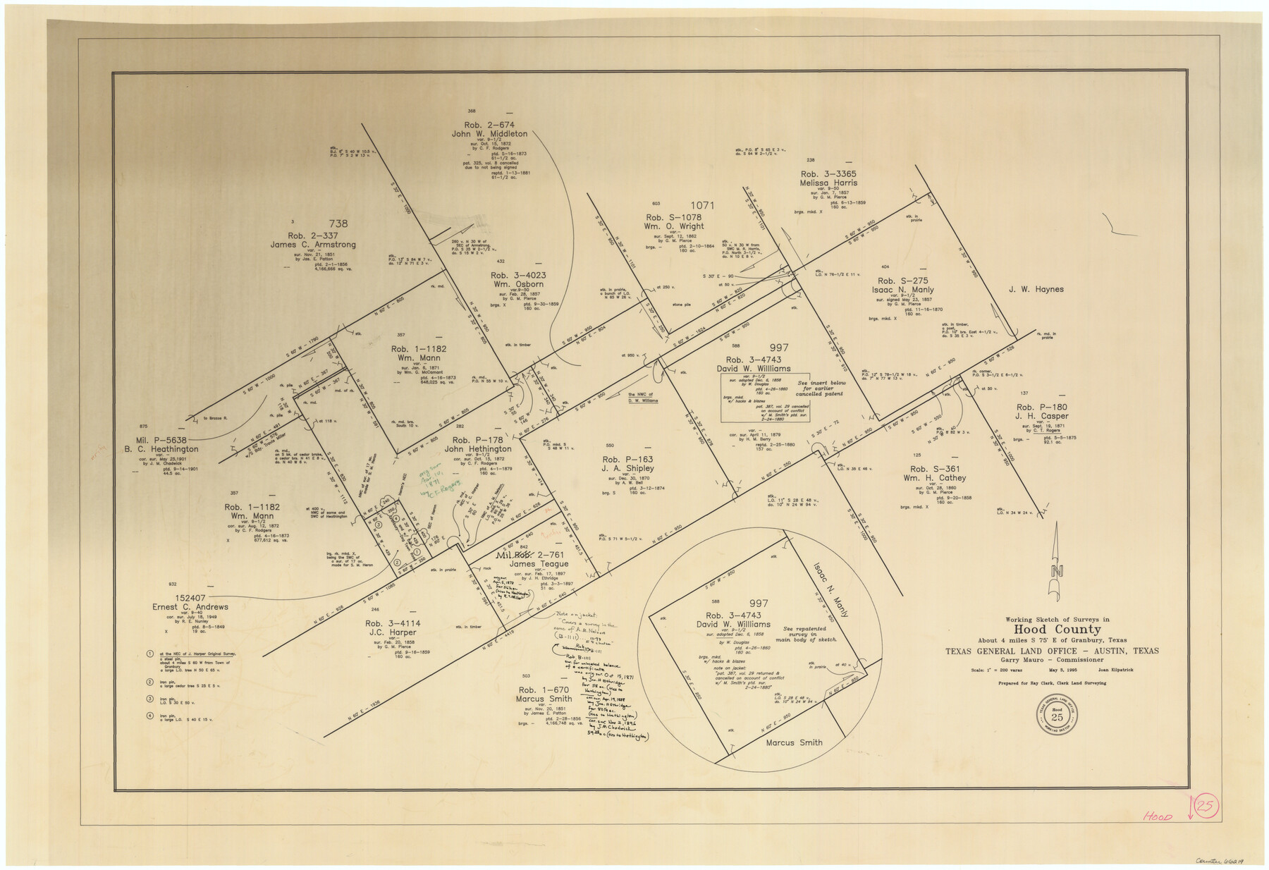
Hood County Working Sketch 25
-
Map/Doc
66219
-
Collection
General Map Collection
-
Object Dates
5/3/1995 (Creation Date)
-
People and Organizations
Joan Kilpatrick (Draftsman)
-
Counties
Hood
-
Subjects
Surveying Working Sketch
-
Height x Width
25.8 x 37.7 inches
65.5 x 95.8 cm
-
Scale
1" = 200 varas
Part of: General Map Collection
Flight Mission No. BRA-8M, Frame 23, Jefferson County

Print $20.00
- Digital $50.00
Flight Mission No. BRA-8M, Frame 23, Jefferson County
1953
Size 18.7 x 22.3 inches
Map/Doc 85578
Donley County Rolled Sketch 3

Print $20.00
- Digital $50.00
Donley County Rolled Sketch 3
1946
Size 15.1 x 21.9 inches
Map/Doc 5729
Flight Mission No. BRE-2P, Frame 134, Nueces County

Print $20.00
- Digital $50.00
Flight Mission No. BRE-2P, Frame 134, Nueces County
1956
Size 18.4 x 22.3 inches
Map/Doc 86807
Map of the Central States to illustrate Olney's school geography

Print $20.00
- Digital $50.00
Map of the Central States to illustrate Olney's school geography
1844
Size 12.1 x 19.0 inches
Map/Doc 93539
Edwards County Working Sketch 4

Print $20.00
- Digital $50.00
Edwards County Working Sketch 4
Size 28.7 x 28.3 inches
Map/Doc 68880
Young County Working Sketch 7

Print $20.00
- Digital $50.00
Young County Working Sketch 7
1919
Size 24.3 x 19.8 inches
Map/Doc 62030
Crockett County Sketch File 33

Print $30.00
- Digital $50.00
Crockett County Sketch File 33
1883
Size 13.0 x 8.2 inches
Map/Doc 19731
[Edwards County]
![4939, [Edwards County], General Map Collection](https://historictexasmaps.com/wmedia_w700/maps/4939-1.tif.jpg)
Print $40.00
- Digital $50.00
[Edwards County]
1900
Size 48.6 x 32.4 inches
Map/Doc 4939
Jasper County Rolled Sketch 7A

Print $20.00
- Digital $50.00
Jasper County Rolled Sketch 7A
Size 22.4 x 14.7 inches
Map/Doc 6354
Childress County Rolled Sketch 9D

Print $3.00
- Digital $50.00
Childress County Rolled Sketch 9D
1945
Size 16.0 x 10.0 inches
Map/Doc 78221
Wichita County Sketch File 32

Print $12.00
- Digital $50.00
Wichita County Sketch File 32
1939
Size 14.2 x 8.8 inches
Map/Doc 40146
Blanco County Sketch File 11

Print $4.00
- Digital $50.00
Blanco County Sketch File 11
Size 4.0 x 7.6 inches
Map/Doc 14590
You may also like
Culberson County Working Sketch 52

Print $20.00
- Digital $50.00
Culberson County Working Sketch 52
1972
Size 37.3 x 39.5 inches
Map/Doc 68506
Blanco County Rolled Sketch 19

Print $20.00
- Digital $50.00
Blanco County Rolled Sketch 19
Size 20.4 x 17.0 inches
Map/Doc 76409
[Brooks & Burleson Block 1]
![90514, [Brooks & Burleson Block 1], Twichell Survey Records](https://historictexasmaps.com/wmedia_w700/maps/90514-1.tif.jpg)
Print $2.00
- Digital $50.00
[Brooks & Burleson Block 1]
1906
Size 9.2 x 11.1 inches
Map/Doc 90514
Hunt County Sketch File 13

Print $2.00
- Digital $50.00
Hunt County Sketch File 13
1855
Size 12.4 x 8.1 inches
Map/Doc 27106
Flight Mission No. BRA-3M, Frame 197, Jefferson County

Print $20.00
- Digital $50.00
Flight Mission No. BRA-3M, Frame 197, Jefferson County
1953
Size 18.6 x 22.4 inches
Map/Doc 85412
Map of Smith County

Print $20.00
- Digital $50.00
Map of Smith County
1855
Size 21.9 x 21.3 inches
Map/Doc 4038
Fort Bend Co.

Print $20.00
- Digital $50.00
Fort Bend Co.
1931
Size 39.1 x 40.8 inches
Map/Doc 73150
Brewster County Rolled Sketch 81

Print $20.00
- Digital $50.00
Brewster County Rolled Sketch 81
1945
Size 30.8 x 33.9 inches
Map/Doc 8494
Rockwall County Boundary File 6

Print $48.00
- Digital $50.00
Rockwall County Boundary File 6
Size 14.0 x 8.6 inches
Map/Doc 58420
Capitol Grounds, Austin

Print $20.00
- Digital $50.00
Capitol Grounds, Austin
Size 35.4 x 40.5 inches
Map/Doc 16955

Hall County Sketch File 25

Print $40.00
- Digital $50.00
Hall County Sketch File 25
1912
Size 14.5 x 13.6 inches
Map/Doc 24822