Crockett County Sketch File 33
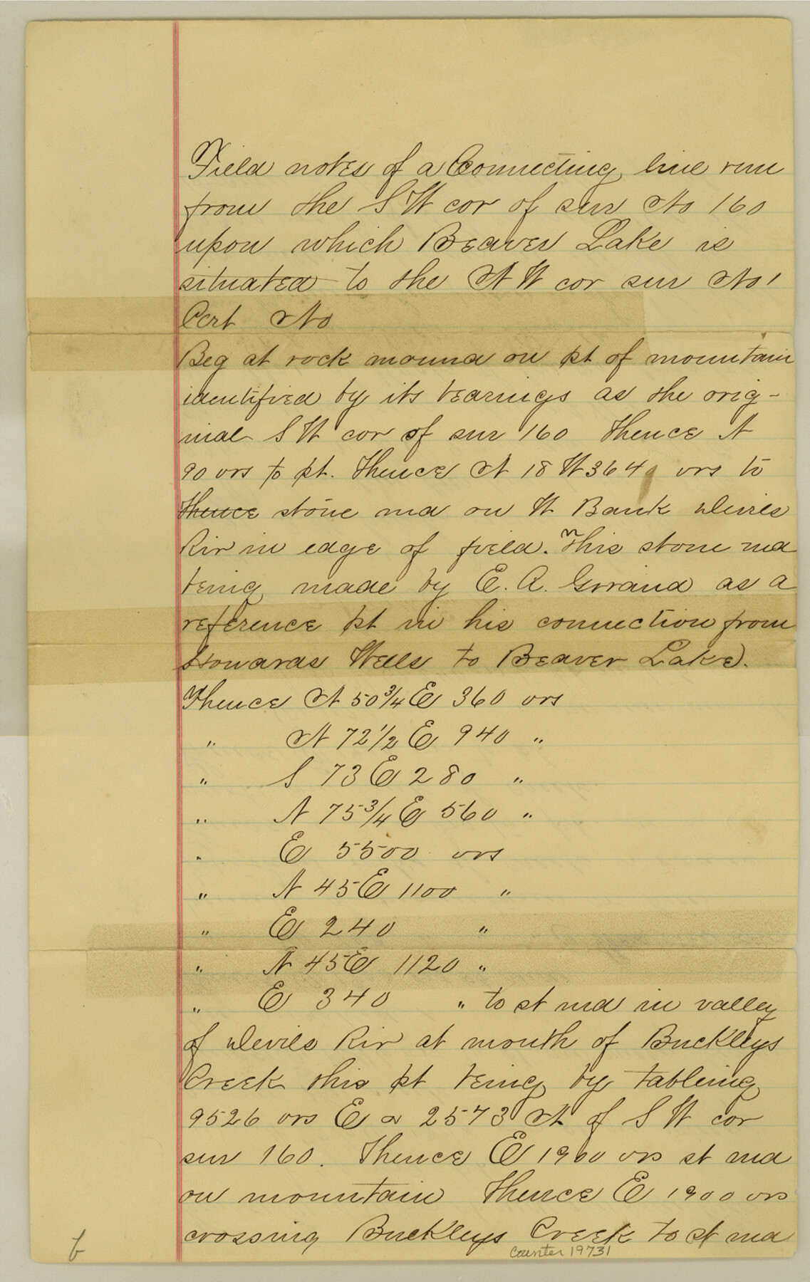
-
Map/Doc
19731
-
Collection
General Map Collection
-
Object Dates
1883 (Creation Date)
1884/10/27 (File Date)
1883 (Survey Date)
-
People and Organizations
W.H. Bonnell (Surveyor/Engineer)
Ike Denton (Chainman)
H. Donaldson (Chainman)
-
Counties
Crockett Val Verde
-
Subjects
Surveying Sketch File
-
Height x Width
13.0 x 8.2 inches
33.0 x 20.8 cm
-
Medium
paper, manuscript
-
Features
Beaver Lake
Devil's River
Howard's Wells
Buckley's Creek
Related maps
Val Verde County Sketch File 2
![39169, Val Verde County Sketch File 2, General Map Collection](https://historictexasmaps.com/wmedia_w700/pdf_converted_jpg/qi_pdf_thumbnail_14786.jpg)
Print $8.00
- Digital $50.00
Val Verde County Sketch File 2
1885
Size 12.8 x 8.0 inches
Map/Doc 39169
Part of: General Map Collection
Maverick County Sketch File 24
![31145, Maverick County Sketch File 24, General Map Collection](https://historictexasmaps.com/wmedia_w700/pdf_converted_jpg/qi_pdf_thumbnail_12946.jpg)
Print $36.00
- Digital $50.00
Maverick County Sketch File 24
1890
Size 9.1 x 8.7 inches
Map/Doc 31145
Archer County Sketch File 8
![10336, Archer County Sketch File 8, General Map Collection](https://historictexasmaps.com/wmedia_w700/pdf_converted_jpg/qi_pdf_thumbnail_7031.jpg)
Print $40.00
- Digital $50.00
Archer County Sketch File 8
Size 40.9 x 31.5 inches
Map/Doc 10336
Estes Quadrangle
![73442, Estes Quadrangle, General Map Collection](https://historictexasmaps.com/wmedia_w700/maps/73442-1.tif.jpg)
Print $20.00
- Digital $50.00
Estes Quadrangle
1971
Size 27.8 x 23.6 inches
Map/Doc 73442
Starr County Rolled Sketch 38
![10297, Starr County Rolled Sketch 38, General Map Collection](https://historictexasmaps.com/wmedia_w700/maps/10297.tif.jpg)
Print $40.00
- Digital $50.00
Starr County Rolled Sketch 38
1944
Size 97.9 x 25.0 inches
Map/Doc 10297
Lavaca County Rolled Sketch 1
![6591, Lavaca County Rolled Sketch 1, General Map Collection](https://historictexasmaps.com/wmedia_w700/maps/6591.tif.jpg)
Print $20.00
- Digital $50.00
Lavaca County Rolled Sketch 1
1947
Size 36.4 x 32.4 inches
Map/Doc 6591
[Sketch for Mineral Applications 26885-6 - Reagan and Crockett Cos., W. H. Bland]
![3219, [Sketch for Mineral Applications 26885-6 - Reagan and Crockett Cos., W. H. Bland], General Map Collection](https://historictexasmaps.com/wmedia_w700/maps/3219.tif.jpg)
Print $20.00
- Digital $50.00
[Sketch for Mineral Applications 26885-6 - Reagan and Crockett Cos., W. H. Bland]
1932
Size 38.4 x 9.7 inches
Map/Doc 3219
Travis County Working Sketch 25
![69409, Travis County Working Sketch 25, General Map Collection](https://historictexasmaps.com/wmedia_w700/maps/69409.tif.jpg)
Print $20.00
- Digital $50.00
Travis County Working Sketch 25
Size 26.4 x 32.0 inches
Map/Doc 69409
Hicks, Station Map-Tracks & Structures Lands, San Antonio & Aransas Pass Railway Co.
![62568, Hicks, Station Map-Tracks & Structures Lands, San Antonio & Aransas Pass Railway Co., General Map Collection](https://historictexasmaps.com/wmedia_w700/maps/62568.tif.jpg)
Print $4.00
- Digital $50.00
Hicks, Station Map-Tracks & Structures Lands, San Antonio & Aransas Pass Railway Co.
1919
Size 11.7 x 18.6 inches
Map/Doc 62568
Hutchinson County Sketch File 21
![27242, Hutchinson County Sketch File 21, General Map Collection](https://historictexasmaps.com/wmedia_w700/pdf_converted_jpg/qi_pdf_thumbnail_12122.jpg)
Print $22.00
- Digital $50.00
Hutchinson County Sketch File 21
Size 8.8 x 7.9 inches
Map/Doc 27242
Val Verde County Working Sketch 100
![72235, Val Verde County Working Sketch 100, General Map Collection](https://historictexasmaps.com/wmedia_w700/maps/72235.tif.jpg)
Print $20.00
- Digital $50.00
Val Verde County Working Sketch 100
Size 22.3 x 32.0 inches
Map/Doc 72235
Hudspeth County Working Sketch 29
![66311, Hudspeth County Working Sketch 29, General Map Collection](https://historictexasmaps.com/wmedia_w700/maps/66311-1.tif.jpg)
Print $40.00
- Digital $50.00
Hudspeth County Working Sketch 29
Size 31.5 x 55.2 inches
Map/Doc 66311
Harris County Boundary File 39 (21)
![54365, Harris County Boundary File 39 (21), General Map Collection](https://historictexasmaps.com/wmedia_w700/pdf_converted_jpg/qi_pdf_thumbnail_16170.jpg)
Print $6.00
- Digital $50.00
Harris County Boundary File 39 (21)
Size 10.2 x 8.1 inches
Map/Doc 54365
You may also like
Waco Manufacturing Company Block 1, G. H. & H. Block 5, Capitol Leagues 229, 230, 234-237]
![90726, Waco Manufacturing Company Block 1, G. H. & H. Block 5, Capitol Leagues 229, 230, 234-237], Twichell Survey Records](https://historictexasmaps.com/wmedia_w700/maps/90726-1.tif.jpg)
Print $20.00
- Digital $50.00
Waco Manufacturing Company Block 1, G. H. & H. Block 5, Capitol Leagues 229, 230, 234-237]
1902
Size 14.5 x 21.6 inches
Map/Doc 90726
Terry County Sketch File 11
![10395, Terry County Sketch File 11, General Map Collection](https://historictexasmaps.com/wmedia_w700/pdf_converted_jpg/qi_pdf_thumbnail_7075.jpg)
Print $20.00
- Digital $50.00
Terry County Sketch File 11
Size 10.9 x 43.2 inches
Map/Doc 10395
San Luis Pass to East Matagorda Bay
![69970, San Luis Pass to East Matagorda Bay, General Map Collection](https://historictexasmaps.com/wmedia_w700/maps/69970.tif.jpg)
Print $40.00
- Digital $50.00
San Luis Pass to East Matagorda Bay
1982
Size 35.6 x 49.3 inches
Map/Doc 69970
Houston County Sketch File 33
![11790, Houston County Sketch File 33, General Map Collection](https://historictexasmaps.com/wmedia_w700/pdf_converted_jpg/qi_pdf_thumbnail_8197.jpg)
Print $20.00
- Digital $50.00
Houston County Sketch File 33
1894
Size 16.9 x 18.4 inches
Map/Doc 11790
Orange County - West one half of Sabine River showing leases 5 & 6 traced from U. S. C. & G. S. chart no. 533
![2899, Orange County - West one half of Sabine River showing leases 5 & 6 traced from U. S. C. & G. S. chart no. 533, General Map Collection](https://historictexasmaps.com/wmedia_w700/maps/2899.tif.jpg)
Print $20.00
- Digital $50.00
Orange County - West one half of Sabine River showing leases 5 & 6 traced from U. S. C. & G. S. chart no. 533
1957
Size 30.6 x 35.4 inches
Map/Doc 2899
Flight Mission No. BRE-1P, Frame 74, Nueces County
![86656, Flight Mission No. BRE-1P, Frame 74, Nueces County, General Map Collection](https://historictexasmaps.com/wmedia_w700/pdf_converted_jpg/qi_pdf_thumbnail_33796.jpg)
Print $20.00
- Digital $50.00
Flight Mission No. BRE-1P, Frame 74, Nueces County
1956
Size 18.5 x 22.3 inches
Map/Doc 86656
Newton County Working Sketch 37
![71283, Newton County Working Sketch 37, General Map Collection](https://historictexasmaps.com/wmedia_w700/maps/71283.tif.jpg)
Print $20.00
- Digital $50.00
Newton County Working Sketch 37
Size 31.7 x 22.7 inches
Map/Doc 71283
Trinity River, Cox Bluff Sheet
![65214, Trinity River, Cox Bluff Sheet, General Map Collection](https://historictexasmaps.com/wmedia_w700/maps/65214.tif.jpg)
Print $20.00
- Digital $50.00
Trinity River, Cox Bluff Sheet
1926
Size 36.0 x 46.2 inches
Map/Doc 65214
Catalogue of Maps, Charts, Atlases, Globes, etc.
![95841, Catalogue of Maps, Charts, Atlases, Globes, etc., Cobb Digital Map Collection](https://historictexasmaps.com/wmedia_w700/pdf_converted_jpg/qi_pdf_thumbnail_39836.jpg)
Catalogue of Maps, Charts, Atlases, Globes, etc.
1891
Size 9.2 x 6.5 inches
Map/Doc 95841
Hale County Sketch File 6
![10468, Hale County Sketch File 6, General Map Collection](https://historictexasmaps.com/wmedia_w700/pdf_converted_jpg/qi_pdf_thumbnail_7142.jpg)
Print $20.00
- Digital $50.00
Hale County Sketch File 6
Size 41.9 x 35.5 inches
Map/Doc 10468
Map of Eastland Co.
![4710, Map of Eastland Co., General Map Collection](https://historictexasmaps.com/wmedia_w700/maps/4710.tif.jpg)
Print $20.00
- Digital $50.00
Map of Eastland Co.
1889
Size 41.6 x 42.7 inches
Map/Doc 4710
General Highway Map, Kenedy County, Texas
![79155, General Highway Map, Kenedy County, Texas, Texas State Library and Archives](https://historictexasmaps.com/wmedia_w700/maps/79155.tif.jpg)
Print $20.00
General Highway Map, Kenedy County, Texas
1940
Size 18.4 x 24.9 inches
Map/Doc 79155