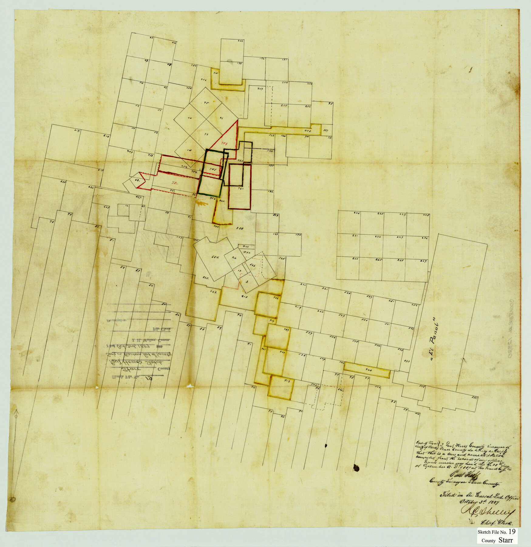
Starr County Sketch File 19
[Sketch of surveys north of the porciones in the eastern part of the county]
-
Map/Doc
12330
-
Collection
General Map Collection
-
Object Dates
9/28/1887 (Creation Date)
10/3/1887 (File Date)
-
People and Organizations
Paul Hesse (Surveyor/Engineer)
-
Counties
Starr
-
Subjects
Surveying Sketch File
-
Height x Width
22.6 x 22.0 inches
57.4 x 55.9 cm
-
Medium
paper, manuscript
Part of: General Map Collection
Liberty County Boundary File 1

Print $8.00
- Digital $50.00
Liberty County Boundary File 1
Size 14.2 x 8.9 inches
Map/Doc 56289
Crockett County Working Sketch 67

Print $20.00
- Digital $50.00
Crockett County Working Sketch 67
1959
Size 26.5 x 31.5 inches
Map/Doc 68400
Chambers County NRC Article 33.136 Sketch 11

Print $28.00
- Digital $50.00
Chambers County NRC Article 33.136 Sketch 11
2014
Size 24.0 x 36.0 inches
Map/Doc 94740
Baylor County Working Sketch 10

Print $20.00
- Digital $50.00
Baylor County Working Sketch 10
1956
Size 37.7 x 18.7 inches
Map/Doc 67295
Midland County Sketch File 18

Print $4.00
- Digital $50.00
Midland County Sketch File 18
Size 14.7 x 8.1 inches
Map/Doc 31585
Oldham County

Print $40.00
- Digital $50.00
Oldham County
1925
Size 41.5 x 53.2 inches
Map/Doc 95604
Flight Mission No. DAH-17M, Frame 24, Orange County

Print $20.00
- Digital $50.00
Flight Mission No. DAH-17M, Frame 24, Orange County
1953
Size 18.5 x 22.4 inches
Map/Doc 86887
Nueces County Sketch File 62

Print $4.00
- Digital $50.00
Nueces County Sketch File 62
1936
Size 8.6 x 14.3 inches
Map/Doc 32971
Flight Mission No. BRA-16M, Frame 68, Jefferson County

Print $20.00
- Digital $50.00
Flight Mission No. BRA-16M, Frame 68, Jefferson County
1953
Size 18.7 x 22.4 inches
Map/Doc 85685
Blanco County Sketch File 31a

Print $4.00
- Digital $50.00
Blanco County Sketch File 31a
1889
Size 8.6 x 14.1 inches
Map/Doc 14631
Eastland County Working Sketch 56

Print $20.00
- Digital $50.00
Eastland County Working Sketch 56
1984
Size 39.2 x 43.3 inches
Map/Doc 68837

You may also like
Map of Nolan County

Print $20.00
- Digital $50.00
Map of Nolan County
1902
Size 47.4 x 37.5 inches
Map/Doc 5021
[League 27, Montgomery County School Land, William Tubbs Survey]
![91127, [League 27, Montgomery County School Land, William Tubbs Survey], Twichell Survey Records](https://historictexasmaps.com/wmedia_w700/maps/91127-1.tif.jpg)
Print $2.00
- Digital $50.00
[League 27, Montgomery County School Land, William Tubbs Survey]
Size 11.7 x 8.9 inches
Map/Doc 91127
Tom Green County Working Sketch 6

Print $40.00
- Digital $50.00
Tom Green County Working Sketch 6
1948
Size 34.2 x 51.3 inches
Map/Doc 69375
Burleson County Working Sketch 11

Print $20.00
- Digital $50.00
Burleson County Working Sketch 11
1980
Size 18.7 x 17.0 inches
Map/Doc 67730
Intracoastal Waterway - Laguna Madre - Rincon de San Jose to Chubby Island, Texas

Print $20.00
- Digital $50.00
Intracoastal Waterway - Laguna Madre - Rincon de San Jose to Chubby Island, Texas
1975
Size 16.0 x 37.1 inches
Map/Doc 73516
Rusk County Working Sketch 8

Print $20.00
- Digital $50.00
Rusk County Working Sketch 8
1981
Size 22.4 x 20.6 inches
Map/Doc 63643
Bastrop County Sketch File 10

Print $4.00
- Digital $50.00
Bastrop County Sketch File 10
1979
Size 14.3 x 8.8 inches
Map/Doc 14056
Webb County Working Sketch Graphic Index - northwest part

Print $40.00
- Digital $50.00
Webb County Working Sketch Graphic Index - northwest part
1984
Size 42.1 x 51.6 inches
Map/Doc 76736
Dimmit County Sketch File 5

Print $42.00
- Digital $50.00
Dimmit County Sketch File 5
1849
Size 8.6 x 8.0 inches
Map/Doc 21064
Railroad Track Map, H&TCRRCo., Falls County, Texas

Print $4.00
- Digital $50.00
Railroad Track Map, H&TCRRCo., Falls County, Texas
1918
Size 11.7 x 18.7 inches
Map/Doc 62845
Flight Mission No. CGI-4N, Frame 185, Cameron County

Print $20.00
- Digital $50.00
Flight Mission No. CGI-4N, Frame 185, Cameron County
1955
Size 18.6 x 22.3 inches
Map/Doc 84688
Walker County Working Sketch 5

Print $20.00
- Digital $50.00
Walker County Working Sketch 5
1934
Size 24.5 x 30.8 inches
Map/Doc 72285