Nueces County Sketch File 62
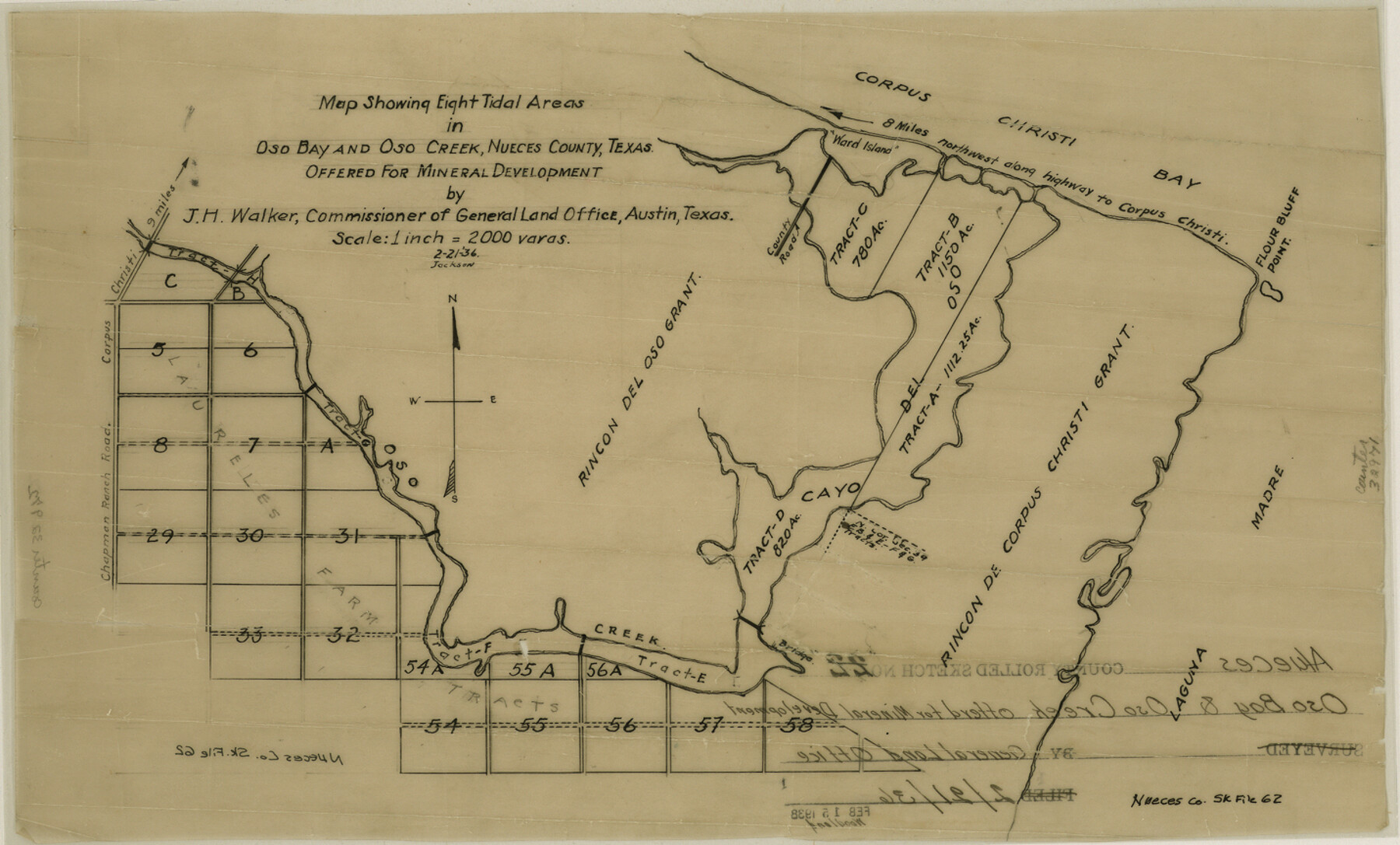
Map showing eight tidal areas in Oso Bay and Oso Creek, Nueces County, Texas offered for mineral development
-
Map/Doc
32971
-
Collection
General Map Collection
-
Object Dates
2/21/1936 (Creation Date)
-
People and Organizations
General Land Office (Surveyor/Engineer)
-
Counties
Nueces
-
Subjects
Surveying Sketch File
-
Height x Width
8.6 x 14.3 inches
21.8 x 36.3 cm
-
Medium
paper, manuscript
-
Scale
1" = 2000 varas
-
Features
Oso Bay
Oso Creek
Corpus Christi Bay
Highway to Corpus Christi
Chapman Ranch Road
Laguna Madre
Part of: General Map Collection
Map of Kerr County

Print $40.00
- Digital $50.00
Map of Kerr County
1895
Size 39.7 x 48.9 inches
Map/Doc 5002
Upton County Sketch File R

Print $4.00
- Digital $50.00
Upton County Sketch File R
Size 13.4 x 8.8 inches
Map/Doc 38848
Texas Gulf Coast from the Sabine River to the Rio Grande Showing Subdivision for Mineral Development.

Print $40.00
- Digital $50.00
Texas Gulf Coast from the Sabine River to the Rio Grande Showing Subdivision for Mineral Development.
1958
Size 46.5 x 118.6 inches
Map/Doc 2944
Angelina County Sketch File 29

Print $4.00
- Digital $50.00
Angelina County Sketch File 29
1911
Size 8.0 x 8.4 inches
Map/Doc 13087
Val Verde County Working Sketch 14

Print $20.00
- Digital $50.00
Val Verde County Working Sketch 14
1926
Size 17.2 x 18.9 inches
Map/Doc 72149
Polk County Working Sketch 11

Print $20.00
- Digital $50.00
Polk County Working Sketch 11
1940
Size 29.3 x 28.6 inches
Map/Doc 71626
Bosque County

Print $40.00
- Digital $50.00
Bosque County
1945
Size 48.3 x 38.0 inches
Map/Doc 73083
Ochiltree County Boundary File 4

Print $4.00
- Digital $50.00
Ochiltree County Boundary File 4
Size 11.1 x 8.7 inches
Map/Doc 57682
[St. L. S-W. Ry. of Texas Map of Lufkin Branch in Angelina County, Texas]
![64561, [St. L. S-W. Ry. of Texas Map of Lufkin Branch in Angelina County, Texas], General Map Collection](https://historictexasmaps.com/wmedia_w700/maps/64561-1.tif.jpg)
Print $40.00
- Digital $50.00
[St. L. S-W. Ry. of Texas Map of Lufkin Branch in Angelina County, Texas]
1913
Size 25.4 x 121.3 inches
Map/Doc 64561
[Surveys along Richland Creek]
![320, [Surveys along Richland Creek], General Map Collection](https://historictexasmaps.com/wmedia_w700/maps/320.tif.jpg)
Print $2.00
- Digital $50.00
[Surveys along Richland Creek]
Size 7.2 x 6.0 inches
Map/Doc 320
Jack County Sketch File 11

Print $4.00
- Digital $50.00
Jack County Sketch File 11
1858
Size 10.2 x 8.1 inches
Map/Doc 27531
Navarro County Working Sketch 8

Print $20.00
- Digital $50.00
Navarro County Working Sketch 8
1955
Size 17.9 x 19.2 inches
Map/Doc 71238
You may also like
Duval County Sketch File 46

Print $4.00
- Digital $50.00
Duval County Sketch File 46
Size 8.8 x 9.4 inches
Map/Doc 21400
Eubank Farm N/2 of NE/4 Section 3, Block D3

Print $20.00
- Digital $50.00
Eubank Farm N/2 of NE/4 Section 3, Block D3
Size 20.9 x 14.0 inches
Map/Doc 92336
Zavala County Working Sketch 5

Print $20.00
- Digital $50.00
Zavala County Working Sketch 5
1940
Size 29.6 x 14.3 inches
Map/Doc 62080
Texas for Tourists, a highway and reference map published by the Dallas Morning News for the Texas Almanac and State Industrial Guide

Texas for Tourists, a highway and reference map published by the Dallas Morning News for the Texas Almanac and State Industrial Guide
1936
Size 20.3 x 26.4 inches
Map/Doc 94294
Wichita County Boundary File 2a

Print $28.00
- Digital $50.00
Wichita County Boundary File 2a
Size 14.0 x 8.9 inches
Map/Doc 59906
Baylor County

Print $20.00
- Digital $50.00
Baylor County
1961
Size 40.6 x 33.0 inches
Map/Doc 77209
Hutchinson County Working Sketch 15

Print $20.00
- Digital $50.00
Hutchinson County Working Sketch 15
1949
Size 26.4 x 15.4 inches
Map/Doc 66373
Flight Mission No. BRA-7M, Frame 141, Jefferson County

Print $20.00
- Digital $50.00
Flight Mission No. BRA-7M, Frame 141, Jefferson County
1953
Size 18.6 x 22.4 inches
Map/Doc 85535
Kendall County Working Sketch 14

Print $20.00
- Digital $50.00
Kendall County Working Sketch 14
1967
Size 37.6 x 33.1 inches
Map/Doc 66686
Carte du Mexique et des Pays Limitrophes Situés au Nord et à l'Est

Print $20.00
- Digital $50.00
Carte du Mexique et des Pays Limitrophes Situés au Nord et à l'Est
1811
Size 17.5 x 29.0 inches
Map/Doc 93421
Flight Mission No. DIX-8P, Frame 88, Aransas County

Print $20.00
- Digital $50.00
Flight Mission No. DIX-8P, Frame 88, Aransas County
1956
Size 18.6 x 22.3 inches
Map/Doc 83913
Flight Mission No. BRA-6M, Frame 148, Jefferson County

Print $20.00
- Digital $50.00
Flight Mission No. BRA-6M, Frame 148, Jefferson County
1953
Size 18.5 x 22.4 inches
Map/Doc 85449