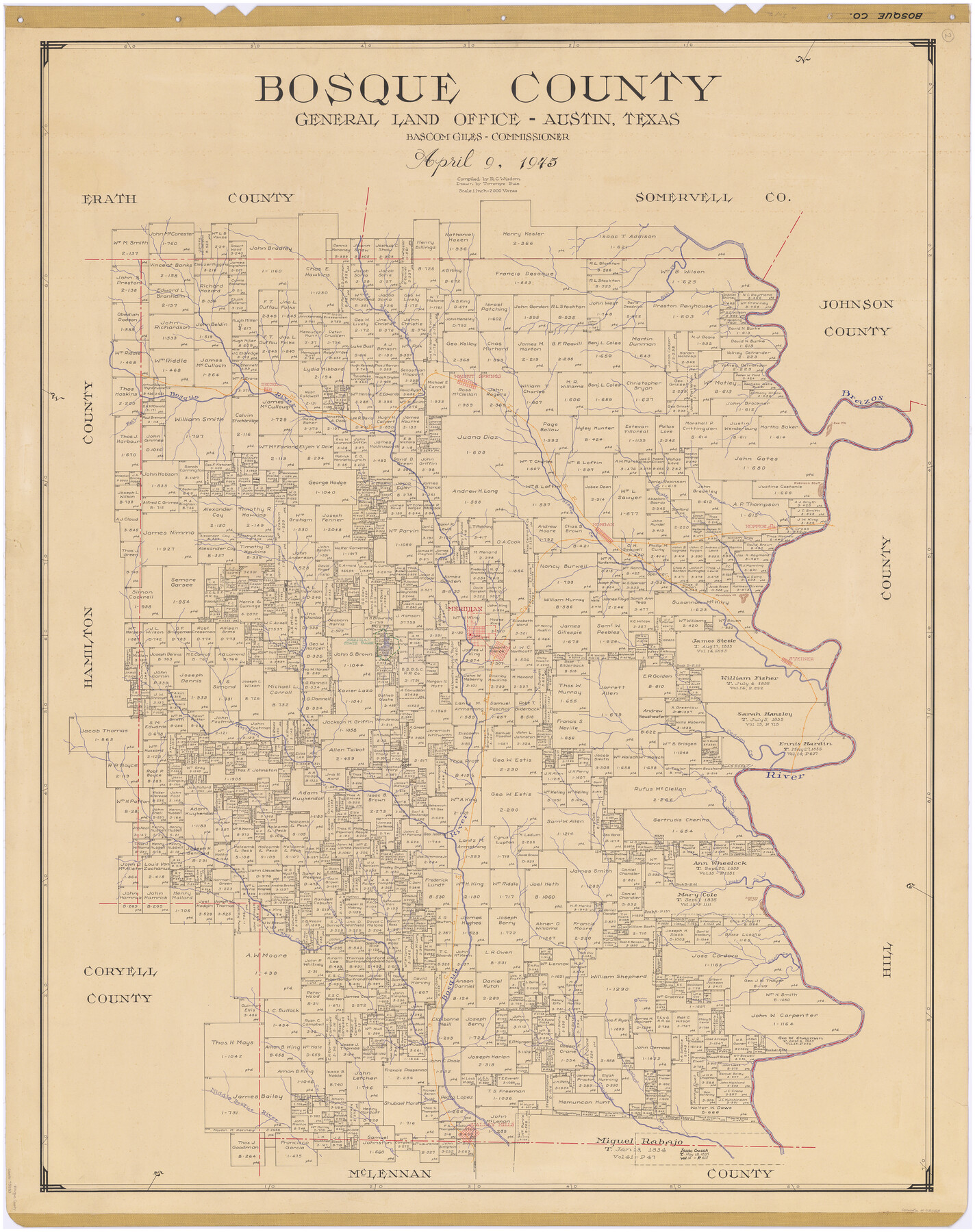
Bosque County
-
Map/Doc
73083
-
Collection
General Map Collection
-
Object Dates
1945/4/9 (Creation Date)
-
People and Organizations
Texas General Land Office (Publisher)
Tommye Buie (Draftsman)
R.C. Wisdom (Compiler)
-
Counties
Bosque
-
Subjects
County
-
Height x Width
48.3 x 38.0 inches
122.7 x 96.5 cm
-
Comments
Hand lettered.
Note on reverse side: "Compilation completed April 9, 1945. Inking completed June 6, 1945. Tracing completed September 4, 1945. Placed in official use September 4, 1945. Replaced [on sticks] by copy June 21, 1946." -
Features
Prairie Springs
Long Branch Creek
GC&SF
Long Branch Canyon Creek
Turkey Creek
Rocky Creek
Soldiers Bluff
Gray Creek
Neil Creek
Coon Creek
Cedron Creek
Willow Creek
Childress Creek
Oak Creek
Middle Bosque River
Hog Creek
Valley Mills
Brazos River
Fall Creek
Hill Creek
Mesquite Creek
Grass Creek
Walnut Springs
Bosque River
Iredell
MK&T
Bee Mountain
Robinson Bluff
Steele Creek
Morgan
East Bosque River
Plowman Creek
Kopperl
Meridian
Powelldale Mountain
Spring Creek
Meridian State Park
Steiner
Meridian Creek
Part of: General Map Collection
Walker County Sketch File 8

Print $4.00
- Digital $50.00
Walker County Sketch File 8
1944
Size 9.7 x 6.8 inches
Map/Doc 39561
Cooke County Working Sketch 17

Print $20.00
- Digital $50.00
Cooke County Working Sketch 17
1950
Size 24.7 x 17.8 inches
Map/Doc 68254
[Right of Way and Track Map, the Missouri, Kansas and Texas Ry. of Texas - Henrietta Division]
![64759, [Right of Way and Track Map, the Missouri, Kansas and Texas Ry. of Texas - Henrietta Division], General Map Collection](https://historictexasmaps.com/wmedia_w700/maps/64759.tif.jpg)
Print $20.00
- Digital $50.00
[Right of Way and Track Map, the Missouri, Kansas and Texas Ry. of Texas - Henrietta Division]
1918
Size 11.9 x 26.8 inches
Map/Doc 64759
Presidio County Working Sketch 97

Print $20.00
- Digital $50.00
Presidio County Working Sketch 97
1978
Size 28.2 x 28.0 inches
Map/Doc 71774
Edwards County Working Sketch 123

Print $20.00
- Digital $50.00
Edwards County Working Sketch 123
1976
Size 18.3 x 25.2 inches
Map/Doc 68999
Webb County Sketch File 12

Print $4.00
- Digital $50.00
Webb County Sketch File 12
Size 13.1 x 8.2 inches
Map/Doc 39791
Collingsworth County Sketch File 5

Print $20.00
- Digital $50.00
Collingsworth County Sketch File 5
1891
Size 32.0 x 24.3 inches
Map/Doc 11132
Culberson County Sketch File 18

Print $8.00
- Digital $50.00
Culberson County Sketch File 18
Size 14.3 x 8.8 inches
Map/Doc 20185
Flight Mission No. BRA-17M, Frame 2, Jefferson County

Print $20.00
- Digital $50.00
Flight Mission No. BRA-17M, Frame 2, Jefferson County
1953
Size 18.6 x 22.3 inches
Map/Doc 85782
Clay County Sketch File 49

Print $78.00
- Digital $50.00
Clay County Sketch File 49
1928
Size 14.2 x 8.8 inches
Map/Doc 18500
Zapata County Working Sketch 16

Print $20.00
- Digital $50.00
Zapata County Working Sketch 16
1969
Size 26.1 x 28.3 inches
Map/Doc 62067
Goliad County Boundary File 33

Print $12.00
- Digital $50.00
Goliad County Boundary File 33
Size 9.4 x 4.2 inches
Map/Doc 53797
You may also like
Maps of Gulf Intracoastal Waterway, Texas - Sabine River to the Rio Grande and connecting waterways including ship channels

Print $20.00
- Digital $50.00
Maps of Gulf Intracoastal Waterway, Texas - Sabine River to the Rio Grande and connecting waterways including ship channels
1966
Size 14.5 x 22.2 inches
Map/Doc 61937
Galveston County NRC Article 33.136 Location Key Sheet

Print $20.00
- Digital $50.00
Galveston County NRC Article 33.136 Location Key Sheet
1994
Size 27.0 x 22.0 inches
Map/Doc 77020
El Paso County Working Sketch 25

Print $20.00
- Digital $50.00
El Paso County Working Sketch 25
1962
Size 42.7 x 41.9 inches
Map/Doc 69047
Flight Mission No. DQO-8K, Frame 16, Galveston County

Print $20.00
- Digital $50.00
Flight Mission No. DQO-8K, Frame 16, Galveston County
1952
Size 18.8 x 22.4 inches
Map/Doc 85139
![90513, [Capitol Lands], Twichell Survey Records](https://historictexasmaps.com/wmedia_w700/maps/90513-1.tif.jpg)
Galveston County Rolled Sketch 47

Print $20.00
- Digital $50.00
Galveston County Rolled Sketch 47
1999
Size 24.6 x 36.7 inches
Map/Doc 77534
Coke County Working Sketch 28

Print $20.00
- Digital $50.00
Coke County Working Sketch 28
1965
Size 32.7 x 42.2 inches
Map/Doc 68065
Mitchell County

Print $20.00
- Digital $50.00
Mitchell County
1889
Size 42.3 x 35.7 inches
Map/Doc 10792
Tyler County Sketch File 9a

Print $4.00
- Digital $50.00
Tyler County Sketch File 9a
1877
Size 8.1 x 7.7 inches
Map/Doc 38646
Parker County Working Sketch 7

Print $20.00
- Digital $50.00
Parker County Working Sketch 7
1955
Map/Doc 71457
Flight Mission No. CRC-3R, Frame 35, Chambers County

Print $20.00
- Digital $50.00
Flight Mission No. CRC-3R, Frame 35, Chambers County
1956
Size 18.5 x 22.2 inches
Map/Doc 84808
Roberts County Working Sketch 13

Print $20.00
- Digital $50.00
Roberts County Working Sketch 13
1971
Size 20.2 x 16.0 inches
Map/Doc 63539