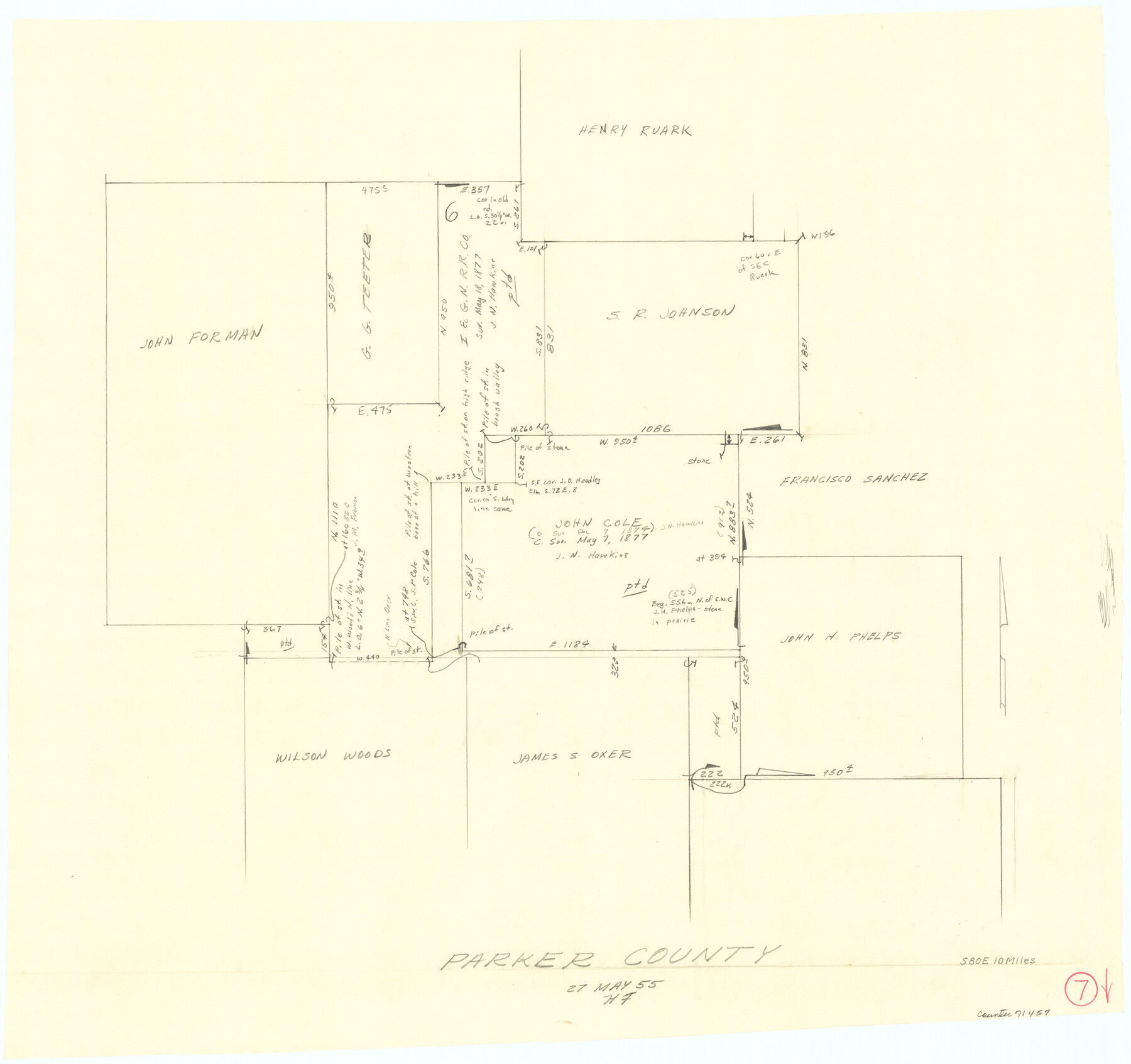
Parker County Working Sketch 7
-
Map/Doc
71457
-
Collection
General Map Collection
-
Object Dates
5/27/1955 (Creation Date)
-
People and Organizations
Herman Forbes (Draftsman)
-
Counties
Parker
-
Subjects
Surveying Working Sketch
Part of: General Map Collection
Harris County Rolled Sketch 41

Print $20.00
- Digital $50.00
Harris County Rolled Sketch 41
1912
Size 21.0 x 34.1 inches
Map/Doc 6099
Dimmit County Working Sketch 21

Print $20.00
- Digital $50.00
Dimmit County Working Sketch 21
1950
Size 35.1 x 18.8 inches
Map/Doc 68682
Brewster County Working Sketch 23

Print $20.00
- Digital $50.00
Brewster County Working Sketch 23
1939
Size 26.7 x 43.6 inches
Map/Doc 67557
A Map of Part of Matagorda Peninsula, State of Texas

Print $40.00
- Digital $50.00
A Map of Part of Matagorda Peninsula, State of Texas
1856
Size 34.4 x 54.2 inches
Map/Doc 69980
Aransas County Sketch File 3

Print $4.00
- Digital $50.00
Aransas County Sketch File 3
Size 8.0 x 12.7 inches
Map/Doc 13104
Hood County Sketch File 20

Print $4.00
- Digital $50.00
Hood County Sketch File 20
1873
Size 6.8 x 6.9 inches
Map/Doc 26607
Flight Mission No. CRE-3R, Frame 42, Jackson County

Print $20.00
- Digital $50.00
Flight Mission No. CRE-3R, Frame 42, Jackson County
1956
Size 18.6 x 22.4 inches
Map/Doc 85389
Knox County Working Sketch 7

Print $3.00
- Digital $50.00
Knox County Working Sketch 7
1941
Size 11.1 x 9.1 inches
Map/Doc 70249
[Surveys along the San Gabriel River]
![78375, [Surveys along the San Gabriel River], General Map Collection](https://historictexasmaps.com/wmedia_w700/maps/78375.tif.jpg)
Print $2.00
- Digital $50.00
[Surveys along the San Gabriel River]
Size 9.0 x 6.3 inches
Map/Doc 78375
San Patricio County Sketch File 25

Print $4.00
San Patricio County Sketch File 25
1875
Size 10.8 x 7.0 inches
Map/Doc 36083
Ochiltree County Sketch File 3

Print $40.00
- Digital $50.00
Ochiltree County Sketch File 3
1908
Size 15.4 x 12.9 inches
Map/Doc 33177
Dallas County Rolled Sketch 5

Print $20.00
- Digital $50.00
Dallas County Rolled Sketch 5
1955
Size 23.8 x 30.8 inches
Map/Doc 5689
You may also like
[Mrs. Adair Resurvey]
![89976, [Mrs. Adair Resurvey], Twichell Survey Records](https://historictexasmaps.com/wmedia_w700/maps/89976-1.tif.jpg)
Print $20.00
- Digital $50.00
[Mrs. Adair Resurvey]
1918
Size 36.5 x 27.4 inches
Map/Doc 89976
Grayson County Sketch File 14

Print $23.00
- Digital $50.00
Grayson County Sketch File 14
1873
Size 14.0 x 12.0 inches
Map/Doc 24482
Flight Mission No. DQO-8K, Frame 16, Galveston County

Print $20.00
- Digital $50.00
Flight Mission No. DQO-8K, Frame 16, Galveston County
1952
Size 18.8 x 22.4 inches
Map/Doc 85139
Orange County - Sabine River Leases 1, 2, 3, & 4

Print $20.00
- Digital $50.00
Orange County - Sabine River Leases 1, 2, 3, & 4
1918
Size 38.6 x 23.0 inches
Map/Doc 2900
Matagorda County Sketch File 45

Print $206.00
- Digital $50.00
Matagorda County Sketch File 45
1967
Size 14.2 x 8.6 inches
Map/Doc 30876
Concho County Sketch File 32

Print $20.00
- Digital $50.00
Concho County Sketch File 32
Size 29.6 x 26.7 inches
Map/Doc 11157
[Beaumont, Sour Lake and Western Ry. Right of Way and Alignment - Frisco]
![64124, [Beaumont, Sour Lake and Western Ry. Right of Way and Alignment - Frisco], General Map Collection](https://historictexasmaps.com/wmedia_w700/maps/64124.tif.jpg)
Print $20.00
- Digital $50.00
[Beaumont, Sour Lake and Western Ry. Right of Way and Alignment - Frisco]
1910
Size 20.4 x 46.0 inches
Map/Doc 64124
Map of Harris County

Print $40.00
- Digital $50.00
Map of Harris County
1896
Size 52.7 x 66.7 inches
Map/Doc 82071
Brown County Sketch File 15

Print $4.00
- Digital $50.00
Brown County Sketch File 15
1857
Size 12.2 x 8.0 inches
Map/Doc 16610
Stonewall County

Print $40.00
- Digital $50.00
Stonewall County
1888
Size 56.1 x 55.2 inches
Map/Doc 89056
Crane County Sketch File 23

Print $20.00
- Digital $50.00
Crane County Sketch File 23
1931
Size 21.3 x 39.1 inches
Map/Doc 11211
Maps of Gulf Intracoastal Waterway, Texas - Sabine River to the Rio Grande and connecting waterways including ship channels

Print $20.00
- Digital $50.00
Maps of Gulf Intracoastal Waterway, Texas - Sabine River to the Rio Grande and connecting waterways including ship channels
1966
Size 14.5 x 22.2 inches
Map/Doc 61940