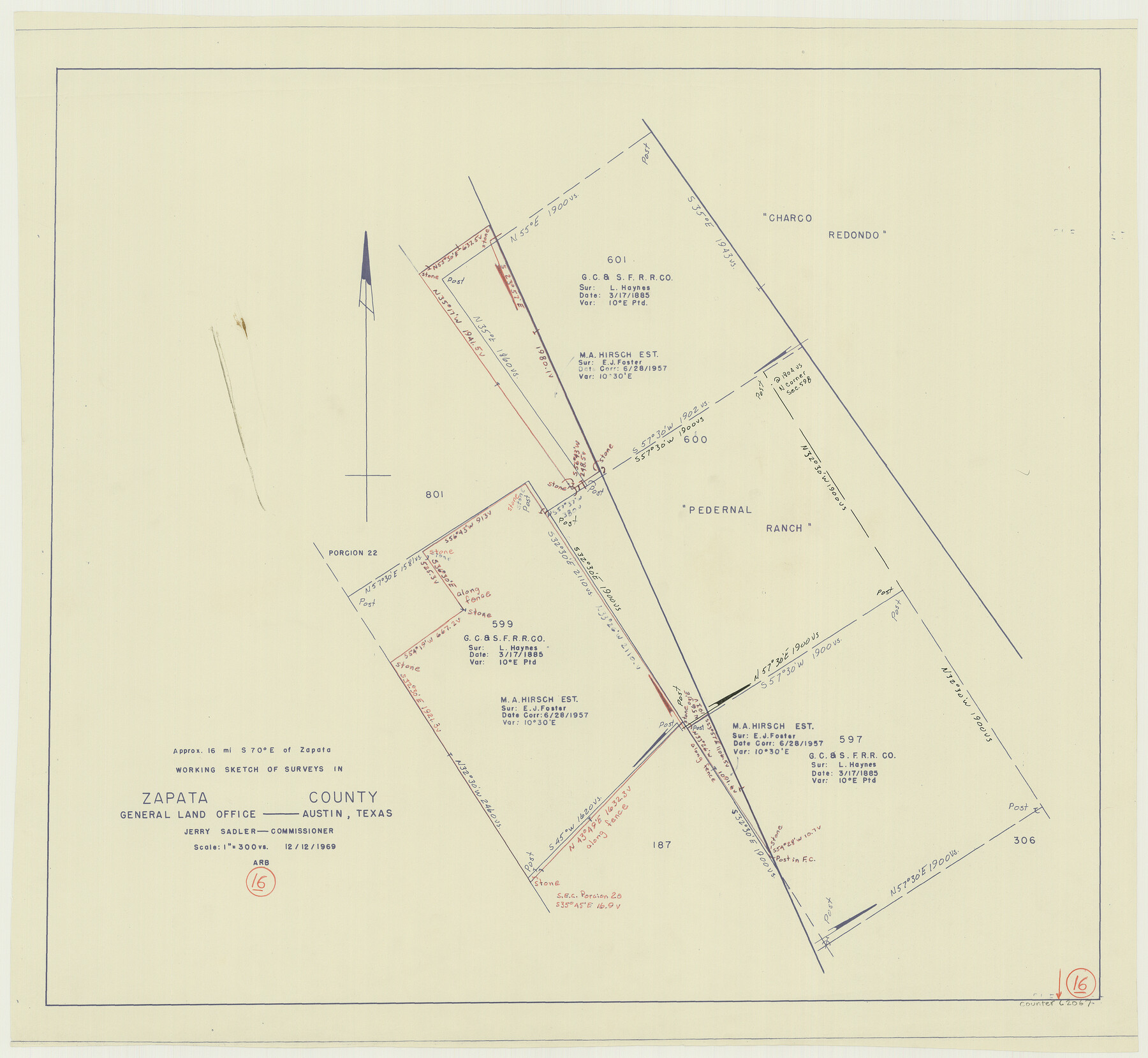
Zapata County Working Sketch 16
- 
                          Map/Doc
62067
 - 
                            Collection
General Map Collection
 - 
                            Object Dates
12/12/1969 (Creation Date)
 - 
                            Counties
Zapata
 - 
                            Subjects
Surveying Working Sketch
 - 
                            Height x Width
26.1 x 28.3 inches
66.3 x 71.9 cm
 - 
                            Scale
1" = 300 varas
 
Part of: General Map Collection
            University Land Field Notes for Blocks 46 and 48 in Culberson County


            University Land Field Notes for Blocks 46 and 48 in Culberson County
Map/Doc 81721
            
            PSL Field Notes for Blocks 110 through 122 in Culberson County and Block 123 in Hudspeth County


            PSL Field Notes for Blocks 110 through 122 in Culberson County and Block 123 in Hudspeth County
Map/Doc 81666
            
            Polk County Sketch File 20


                                            Print $4.00                    
                                             -                         Digital $50.00                                    
                Polk County Sketch File 20
Size 6.1 x 8.2 inches
                                Map/Doc 34167
            
            Lamb County Boundary File 1


                                            Print $10.00                    
                                             -                         Digital $50.00                                    
                Lamb County Boundary File 1
Size 11.1 x 8.5 inches
                                Map/Doc 56027
            
            Map of the Connection of S. C. Robertson's Survey


                                            Print $3.00                    
                                             -                         Digital $50.00                                    
                Map of the Connection of S. C. Robertson's Survey
1846
Size 10.5 x 16.0 inches
                                Map/Doc 334
            
            Wichita County Sketch File R


                                            Print $8.00                    
                                             -                         Digital $50.00                                    
                Wichita County Sketch File R
Size 14.3 x 8.8 inches
                                Map/Doc 40142
            
            Webb County Rolled Sketch 72


                                            Print $20.00                    
                                             -                         Digital $50.00                                    
                Webb County Rolled Sketch 72
1976
Size 25.5 x 17.5 inches
                                Map/Doc 8220
            
            Ochiltree County


                                            Print $20.00                    
                                             -                         Digital $50.00                                    
                Ochiltree County
1908
Size 42.5 x 40.6 inches
                                Map/Doc 66959
            
            Edwards County Working Sketch 83


                                            Print $20.00                    
                                             -                         Digital $50.00                                    
                Edwards County Working Sketch 83
1965
Size 29.2 x 34.3 inches
                                Map/Doc 68959
            
            Location Survey of the Southern Kansas Railway, Kiowa Extension from a point in Drake's Location, in Indian Territory 100 miles from south line of Kansas, continuing up Wolf Creek and South Canadian River to Cottonwood Creek in Hutchinson County


                                            Print $40.00                    
                                             -                         Digital $50.00                                    
                Location Survey of the Southern Kansas Railway, Kiowa Extension from a point in Drake's Location, in Indian Territory 100 miles from south line of Kansas, continuing up Wolf Creek and South Canadian River to Cottonwood Creek in Hutchinson County
1886
Size 37.5 x 282.7 inches
                                Map/Doc 88837
            
            Flight Mission No. DQN-3K, Frame 71, Calhoun County


                                            Print $20.00                    
                                             -                         Digital $50.00                                    
                Flight Mission No. DQN-3K, Frame 71, Calhoun County
1953
Size 18.7 x 22.3 inches
                                Map/Doc 84362
            You may also like
            Travis County Rolled Sketch 29


                                            Print $20.00                    
                                             -                         Digital $50.00                                    
                Travis County Rolled Sketch 29
1946
Size 25.1 x 37.8 inches
                                Map/Doc 8031
            
            Presidio County Sketch File 119


                                            Print $14.00                    
                                             -                         Digital $50.00                                    
                Presidio County Sketch File 119
1996
Size 14.3 x 9.0 inches
                                Map/Doc 34927
            
            General Highway Map, Borden County, Texas


                                            Print $20.00                    
                                    
                General Highway Map, Borden County, Texas
1961
Size 18.3 x 25.0 inches
                                Map/Doc 79377
            
            Winkler County Working Sketch 5


                                            Print $40.00                    
                                             -                         Digital $50.00                                    
                Winkler County Working Sketch 5
1957
Size 31.1 x 131.9 inches
                                Map/Doc 72599
            
            Loving County


                                            Print $20.00                    
                                             -                         Digital $50.00                                    
                Loving County
1932
Size 35.0 x 45.6 inches
                                Map/Doc 73225
            
            Johnson County Working Sketch 35


                                            Print $20.00                    
                                             -                         Digital $50.00                                    
                Johnson County Working Sketch 35
2009
Size 23.2 x 28.6 inches
                                Map/Doc 89043
            
            Webb County Working Sketch 62


                                            Print $20.00                    
                                             -                         Digital $50.00                                    
                Webb County Working Sketch 62
1962
Size 24.8 x 29.9 inches
                                Map/Doc 72428
            
            Hartley County Sketch File 12


                                            Print $20.00                    
                                             -                         Digital $50.00                                    
                Hartley County Sketch File 12
1906
Size 16.3 x 12.4 inches
                                Map/Doc 11736
            
            Map of Brett Ranch situated in McMullen & La Salle Counties


                                            Print $20.00                    
                                             -                         Digital $50.00                                    
                Map of Brett Ranch situated in McMullen & La Salle Counties
Size 20.0 x 22.3 inches
                                Map/Doc 5068
            
            Val Verde County Working Sketch 117


                                            Print $20.00                    
                                             -                         Digital $50.00                                    
                Val Verde County Working Sketch 117
1993
Size 33.8 x 37.0 inches
                                Map/Doc 82842
            
            The Republic County of Liberty. Spring 1842


                                            Print $20.00                    
                                    
                The Republic County of Liberty. Spring 1842
2020
Size 19.9 x 21.7 inches
                                Map/Doc 96212
            
            Live Oak County Working Sketch 29


                                            Print $20.00                    
                                             -                         Digital $50.00                                    
                Live Oak County Working Sketch 29
1983
Size 33.7 x 42.8 inches
                                Map/Doc 70614