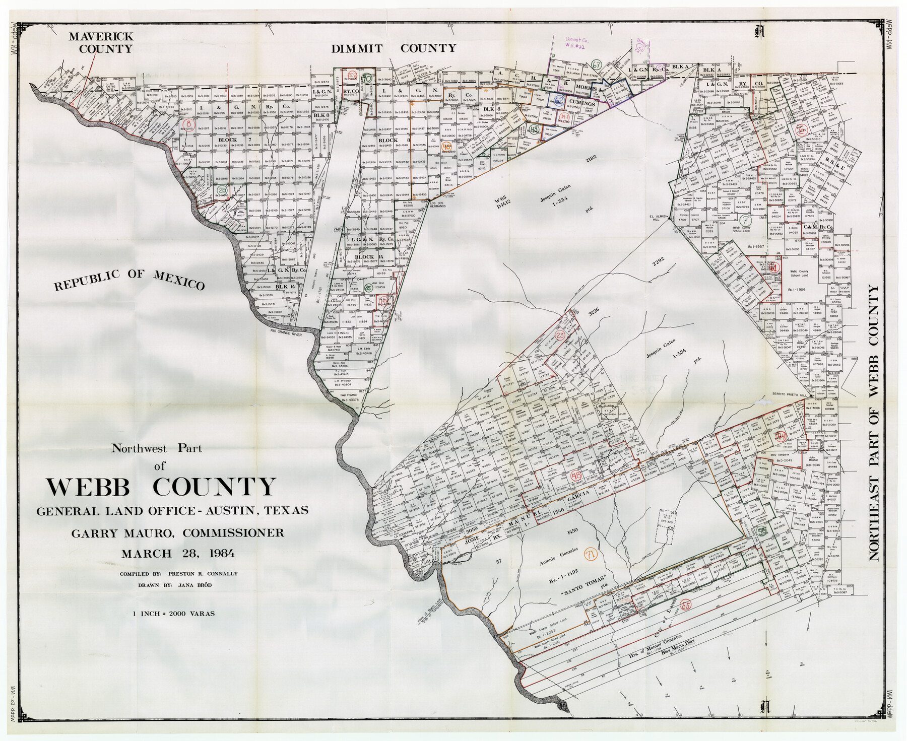
Webb County Working Sketch Graphic Index - northwest part
-
Map/Doc
76736
-
Collection
General Map Collection
-
Object Dates
3/28/1984 (Creation Date)
-
People and Organizations
Preston R. Connally (Compiler)
Jana Brod (Draftsman)
-
Counties
Webb
-
Subjects
County Surveying Working Sketch
-
Height x Width
42.1 x 51.6 inches
106.9 x 131.1 cm
-
Scale
1" = 2000 varas
Part of: General Map Collection
Fisher County Rolled Sketch 4

Print $20.00
- Digital $50.00
Fisher County Rolled Sketch 4
1950
Size 32.4 x 37.5 inches
Map/Doc 8888
Reagan County Working Sketch 3

Print $40.00
- Digital $50.00
Reagan County Working Sketch 3
1923
Size 42.6 x 54.3 inches
Map/Doc 71843
Angelina County Working Sketch 29

Print $20.00
- Digital $50.00
Angelina County Working Sketch 29
1955
Size 24.9 x 23.3 inches
Map/Doc 67111
Flight Mission No. DCL-5C, Frame 70, Kenedy County

Print $20.00
- Digital $50.00
Flight Mission No. DCL-5C, Frame 70, Kenedy County
1943
Size 18.7 x 22.2 inches
Map/Doc 85853
McMullen County Working Sketch 50

Print $20.00
- Digital $50.00
McMullen County Working Sketch 50
1983
Size 18.4 x 18.0 inches
Map/Doc 70751
Map of Coryell County

Print $20.00
- Digital $50.00
Map of Coryell County
1863
Size 23.1 x 27.4 inches
Map/Doc 3443
Jefferson County Working Sketch 35

Print $20.00
- Digital $50.00
Jefferson County Working Sketch 35
1982
Size 39.1 x 32.6 inches
Map/Doc 66579
Sketch A Shewing the progress of the Survey in Section No. 1 From 1844 to 1852

Print $20.00
- Digital $50.00
Sketch A Shewing the progress of the Survey in Section No. 1 From 1844 to 1852
1852
Size 38.1 x 25.3 inches
Map/Doc 97200
Leon County Sketch File 31

Print $20.00
- Digital $50.00
Leon County Sketch File 31
Size 19.1 x 20.5 inches
Map/Doc 11993
Kaufman County Sketch File 3

Print $20.00
- Digital $50.00
Kaufman County Sketch File 3
1857
Size 25.3 x 18.7 inches
Map/Doc 4856
Stonewall County Rolled Sketch 26

Print $40.00
- Digital $50.00
Stonewall County Rolled Sketch 26
1954
Size 49.4 x 32.8 inches
Map/Doc 9965

You may also like
Stephens County Sketch File 15

Print $4.00
- Digital $50.00
Stephens County Sketch File 15
1890
Size 9.1 x 6.7 inches
Map/Doc 37068
Padre Island Under Six Flags

Print $40.00
- Digital $50.00
Padre Island Under Six Flags
1962
Size 59.3 x 30.3 inches
Map/Doc 3123
Mason County Rolled Sketch 8

Print $20.00
- Digital $50.00
Mason County Rolled Sketch 8
2010
Size 18.5 x 24.4 inches
Map/Doc 89283
[Blocks 21, 22, 23, and 24]
![91110, [Blocks 21, 22, 23, and 24], Twichell Survey Records](https://historictexasmaps.com/wmedia_w700/maps/91110-1.tif.jpg)
Print $20.00
- Digital $50.00
[Blocks 21, 22, 23, and 24]
Size 14.0 x 12.8 inches
Map/Doc 91110
[Bastrop County School Land Leagues 313 and 314, Thos. H. Cosby League 315 and El Paso County School Land League 316 and surrounding surveys]
![90819, [Bastrop County School Land Leagues 313 and 314, Thos. H. Cosby League 315 and El Paso County School Land League 316 and surrounding surveys], Twichell Survey Records](https://historictexasmaps.com/wmedia_w700/maps/90819-2.tif.jpg)
Print $3.00
- Digital $50.00
[Bastrop County School Land Leagues 313 and 314, Thos. H. Cosby League 315 and El Paso County School Land League 316 and surrounding surveys]
1898
Size 10.5 x 12.6 inches
Map/Doc 90819
Red River County Working Sketch 46

Print $20.00
- Digital $50.00
Red River County Working Sketch 46
Size 34.3 x 38.9 inches
Map/Doc 72029
Taylor County Rolled Sketch 27A

Print $20.00
- Digital $50.00
Taylor County Rolled Sketch 27A
Size 30.5 x 21.4 inches
Map/Doc 7919
Map of the Survey of the Parallel 36 1/2 Degrees North Latitude, Commencing at the 100th and Running to the 103rd Degree of Longitude West of Greenwich

Print $40.00
- Digital $50.00
Map of the Survey of the Parallel 36 1/2 Degrees North Latitude, Commencing at the 100th and Running to the 103rd Degree of Longitude West of Greenwich
1862
Size 115.6 x 14.9 inches
Map/Doc 73566

Terrell County Rolled Sketch 60

Print $20.00
- Digital $50.00
Terrell County Rolled Sketch 60
1998
Size 13.2 x 38.1 inches
Map/Doc 7976
Trinity County Working Sketch 4

Print $20.00
- Digital $50.00
Trinity County Working Sketch 4
1908
Size 21.3 x 18.5 inches
Map/Doc 69452
Rusk County Working Sketch 33

Print $20.00
- Digital $50.00
Rusk County Working Sketch 33
1919
Size 20.1 x 16.6 inches
Map/Doc 63670