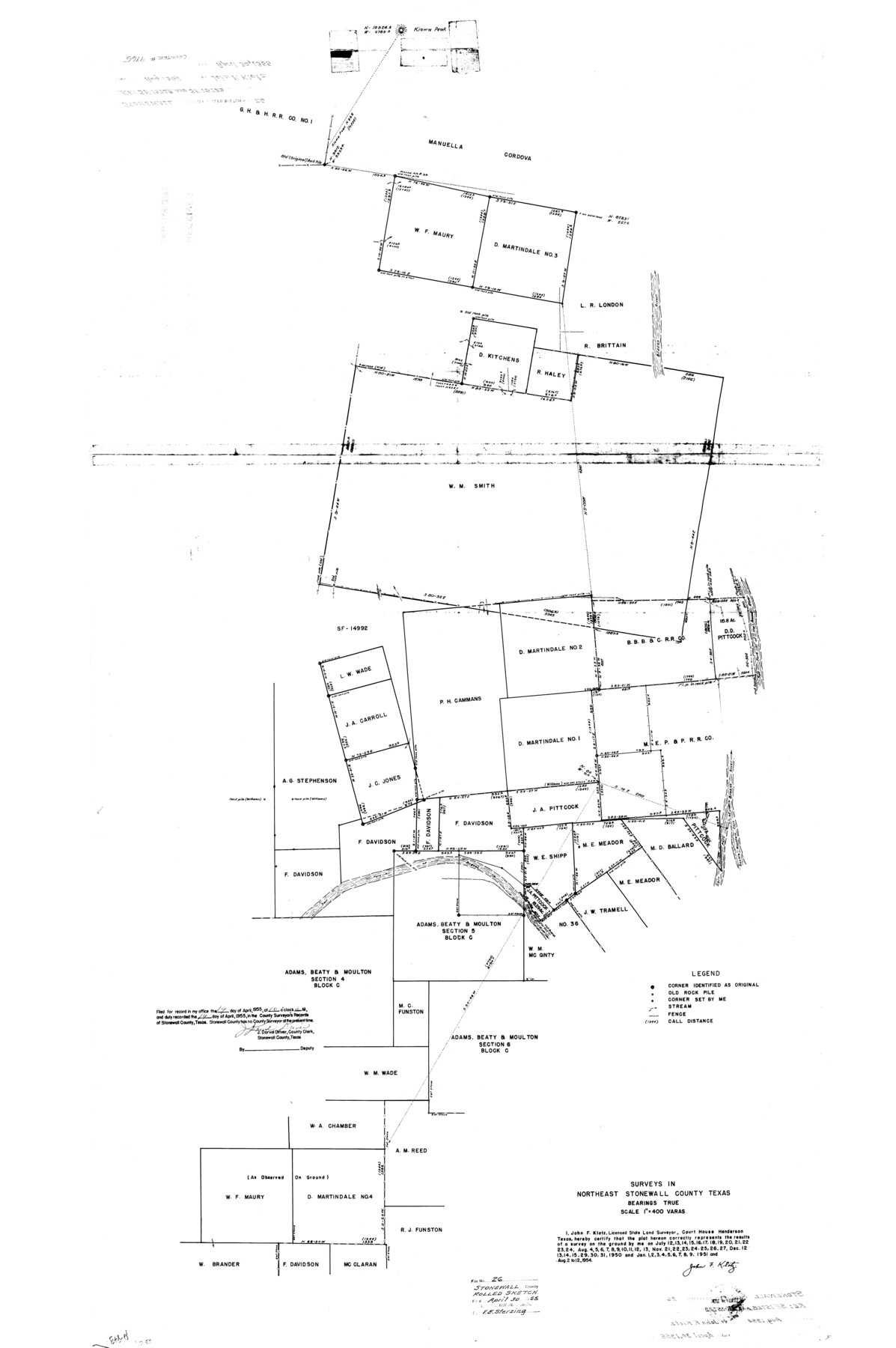
Stonewall County Rolled Sketch 26
Surveys in northeast Stonewall County, Texas
-
Map/Doc
9965
-
Collection
General Map Collection
-
Object Dates
8/12/1954 (Creation Date)
4/30/1955 (File Date)
-
People and Organizations
John F. Klotz (Surveyor/Engineer)
-
Counties
Stonewall
-
Subjects
Surveying Rolled Sketch
-
Height x Width
49.4 x 32.8 inches
125.5 x 83.3 cm
-
Scale
1" = 400 varas
Part of: General Map Collection
Clay County Sketch File 39

Print $10.00
- Digital $50.00
Clay County Sketch File 39
1940
Size 14.3 x 8.7 inches
Map/Doc 18472
Lubbock County Sketch File 2

Print $4.00
- Digital $50.00
Lubbock County Sketch File 2
Size 4.7 x 9.2 inches
Map/Doc 30418
Fractional Township No. 7 South Range No. 1 West of the Indian Meridian, Indian Territory

Print $20.00
- Digital $50.00
Fractional Township No. 7 South Range No. 1 West of the Indian Meridian, Indian Territory
1898
Size 19.2 x 24.4 inches
Map/Doc 75197
Blanco County Sketch File 21b

Print $40.00
- Digital $50.00
Blanco County Sketch File 21b
1882
Size 16.9 x 17.8 inches
Map/Doc 10930
Young County Sketch File 11

Print $4.00
- Digital $50.00
Young County Sketch File 11
1877
Size 10.1 x 8.5 inches
Map/Doc 40874
Live Oak County Working Sketch 16

Print $20.00
- Digital $50.00
Live Oak County Working Sketch 16
1954
Size 22.2 x 21.8 inches
Map/Doc 70601
Flight Mission No. CGI-4N, Frame 172, Cameron County

Print $20.00
- Digital $50.00
Flight Mission No. CGI-4N, Frame 172, Cameron County
1955
Size 18.5 x 22.3 inches
Map/Doc 84675
[Surveys along the Trinity River, Bois d'Arc Creek and White Rock Lake]
![256, [Surveys along the Trinity River, Bois d'Arc Creek and White Rock Lake], General Map Collection](https://historictexasmaps.com/wmedia_w700/maps/256.tif.jpg)
Print $2.00
- Digital $50.00
[Surveys along the Trinity River, Bois d'Arc Creek and White Rock Lake]
Size 10.8 x 6.7 inches
Map/Doc 256
Bandera County Working Sketch 46

Print $20.00
- Digital $50.00
Bandera County Working Sketch 46
1981
Size 28.0 x 37.4 inches
Map/Doc 67642
Carte du Spits-Berg, et partie de la Côte de Galles hams-kes au nouveau Groenland

Print $20.00
- Digital $50.00
Carte du Spits-Berg, et partie de la Côte de Galles hams-kes au nouveau Groenland
1782
Size 13.8 x 19.8 inches
Map/Doc 97123
Colorado County Working Sketch 6

Print $20.00
- Digital $50.00
Colorado County Working Sketch 6
1921
Size 15.4 x 14.3 inches
Map/Doc 68106
Chambers County Rolled Sketch 23A

Print $40.00
- Digital $50.00
Chambers County Rolled Sketch 23A
1940
Size 77.1 x 36.0 inches
Map/Doc 8592
You may also like
Blanco County Working Sketch 38

Print $40.00
- Digital $50.00
Blanco County Working Sketch 38
1984
Size 57.8 x 43.1 inches
Map/Doc 67398
Map of Bell County

Print $40.00
- Digital $50.00
Map of Bell County
1896
Size 48.1 x 54.4 inches
Map/Doc 82066
Stonewall County Working Sketch 30

Print $20.00
- Digital $50.00
Stonewall County Working Sketch 30
1982
Size 28.6 x 29.0 inches
Map/Doc 62337
General Highway Map, Mills County, Texas

Print $20.00
General Highway Map, Mills County, Texas
1961
Size 18.2 x 24.6 inches
Map/Doc 79599
Flight Mission No. DIX-10P, Frame 80, Aransas County

Print $20.00
- Digital $50.00
Flight Mission No. DIX-10P, Frame 80, Aransas County
1956
Size 18.8 x 22.4 inches
Map/Doc 83941
Amistad International Reservoir on Rio Grande 109

Print $20.00
- Digital $50.00
Amistad International Reservoir on Rio Grande 109
1950
Size 28.6 x 41.3 inches
Map/Doc 75540
[Township 5-S, Blocks 36, 37 & 38]
![92291, [Township 5-S, Blocks 36, 37 & 38], Twichell Survey Records](https://historictexasmaps.com/wmedia_w700/maps/92291-1.tif.jpg)
Print $20.00
- Digital $50.00
[Township 5-S, Blocks 36, 37 & 38]
1952
Size 27.6 x 26.5 inches
Map/Doc 92291
Collingsworth County

Print $20.00
- Digital $50.00
Collingsworth County
1899
Size 42.7 x 39.7 inches
Map/Doc 4915
Maverick County Working Sketch 13

Print $20.00
- Digital $50.00
Maverick County Working Sketch 13
1969
Size 27.3 x 35.8 inches
Map/Doc 70905
Upper Galveston Bay, Houston Ship Channel, Dollar Pt. to Atkinson I.

Print $40.00
- Digital $50.00
Upper Galveston Bay, Houston Ship Channel, Dollar Pt. to Atkinson I.
1976
Size 49.3 x 36.5 inches
Map/Doc 69897
Map of Asylum Lands

Print $20.00
- Digital $50.00
Map of Asylum Lands
1857
Size 28.4 x 18.5 inches
Map/Doc 2459
Webb County Sketch File 17

Print $20.00
- Digital $50.00
Webb County Sketch File 17
Size 13.5 x 15.4 inches
Map/Doc 12636