Webb County Sketch File 44b
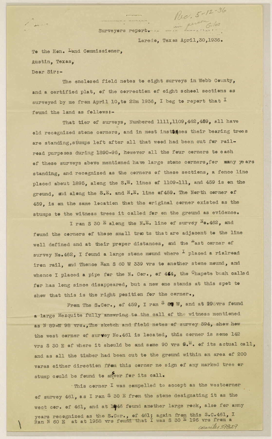
[Surveyor's statement regarding area west of the "Los Ojuelos" grant and northeast from the Borrego grant]
-
Map/Doc
39829
-
Collection
General Map Collection
-
Object Dates
4/30/1936 (Creation Date)
5/12/1936 (File Date)
-
People and Organizations
E.J. Foster (Surveyor/Engineer)
-
Counties
Webb
-
Subjects
Surveying Sketch File
-
Height x Width
14.5 x 9.0 inches
36.8 x 22.9 cm
-
Medium
paper, print
-
Comments
See Webb County Sketch File 44a (12640) and Webb County Sketch File 44b-1 (12641) for sketches.
Related maps
Webb County Sketch File 44a

Print $20.00
- Digital $50.00
Webb County Sketch File 44a
1936
Size 29.4 x 18.2 inches
Map/Doc 12640
Webb County Sketch File 44b-1

Print $20.00
- Digital $50.00
Webb County Sketch File 44b-1
1936
Size 29.0 x 18.0 inches
Map/Doc 12641
Part of: General Map Collection
Flight Mission No. DQO-7K, Frame 83, Galveston County

Print $20.00
- Digital $50.00
Flight Mission No. DQO-7K, Frame 83, Galveston County
1952
Size 18.8 x 22.5 inches
Map/Doc 85110
Wise County Working Sketch 10

Print $20.00
- Digital $50.00
Wise County Working Sketch 10
Size 17.4 x 18.4 inches
Map/Doc 72624
Flight Mission No. DQN-2K, Frame 95, Calhoun County

Print $20.00
- Digital $50.00
Flight Mission No. DQN-2K, Frame 95, Calhoun County
1953
Size 18.6 x 22.3 inches
Map/Doc 84285
Flight Mission No. BRA-16M, Frame 62, Jefferson County

Print $20.00
- Digital $50.00
Flight Mission No. BRA-16M, Frame 62, Jefferson County
1953
Size 18.7 x 22.4 inches
Map/Doc 85679

Scurry County Sketch File 6

Print $14.00
- Digital $50.00
Scurry County Sketch File 6
2002
Size 11.2 x 8.7 inches
Map/Doc 76370
Map showing state tracts in E. part of Corpus Christi Bay and surveys on Harbor Island & Corpus Christi channel

Print $40.00
- Digital $50.00
Map showing state tracts in E. part of Corpus Christi Bay and surveys on Harbor Island & Corpus Christi channel
1978
Size 53.4 x 37.7 inches
Map/Doc 2501
Map of Crockett County

Print $40.00
- Digital $50.00
Map of Crockett County
1878
Size 62.6 x 49.7 inches
Map/Doc 93373
Fractional Township No. 8 South Range No. 23 East of the Indian Meridian, Indian Territory

Print $20.00
- Digital $50.00
Fractional Township No. 8 South Range No. 23 East of the Indian Meridian, Indian Territory
1898
Size 19.1 x 24.3 inches
Map/Doc 75249
Hudspeth County Sketch File 31

Print $20.00
- Digital $50.00
Hudspeth County Sketch File 31
1908
Size 18.7 x 17.7 inches
Map/Doc 11805
Nolan County Sketch File 1

Print $48.00
- Digital $50.00
Nolan County Sketch File 1
1890
Size 14.1 x 8.5 inches
Map/Doc 32470
Nueces County Rolled Sketch 79

Print $20.00
- Digital $50.00
Nueces County Rolled Sketch 79
1894
Size 38.1 x 31.3 inches
Map/Doc 9627
You may also like
Harris County NRC Article 33.136 Sketch 7

Print $20.00
- Digital $50.00
Harris County NRC Article 33.136 Sketch 7
2004
Size 24.3 x 18.5 inches
Map/Doc 82991
Cooke County Working Sketch 25

Print $20.00
- Digital $50.00
Cooke County Working Sketch 25
1974
Size 31.7 x 22.9 inches
Map/Doc 68262
Current Miscellaneous File 98

Print $40.00
- Digital $50.00
Current Miscellaneous File 98
Size 18.4 x 26.3 inches
Map/Doc 74338
Red River County Working Sketch 77

Print $20.00
- Digital $50.00
Red River County Working Sketch 77
1981
Size 34.9 x 23.8 inches
Map/Doc 72060
Presidio County Working Sketch 78

Print $20.00
- Digital $50.00
Presidio County Working Sketch 78
1965
Size 24.8 x 25.1 inches
Map/Doc 71755
Mills County Rolled Sketch 3

Print $20.00
- Digital $50.00
Mills County Rolled Sketch 3
1998
Size 26.4 x 37.9 inches
Map/Doc 6781
Flight Mission No. DAG-23K, Frame 148, Matagorda County

Print $20.00
- Digital $50.00
Flight Mission No. DAG-23K, Frame 148, Matagorda County
1953
Size 18.6 x 22.4 inches
Map/Doc 86496
Origin of Imports and Destination of Exports at Texas City, Tex., during 1921

Print $20.00
- Digital $50.00
Origin of Imports and Destination of Exports at Texas City, Tex., during 1921
1921
Size 13.4 x 24.9 inches
Map/Doc 97163
Sutton County Sketch File 54

Print $6.00
- Digital $50.00
Sutton County Sketch File 54
1948
Size 10.8 x 11.5 inches
Map/Doc 37534
Presidio County Rolled Sketch 102

Print $20.00
- Digital $50.00
Presidio County Rolled Sketch 102
1957
Size 22.8 x 17.4 inches
Map/Doc 7384
[I. M. Bolton, L. S. Thacker, and R. C. Poteet Subdivisions]
![92577, [I. M. Bolton, L. S. Thacker, and R. C. Poteet Subdivisions], Twichell Survey Records](https://historictexasmaps.com/wmedia_w700/maps/92577-1.tif.jpg)
Print $20.00
- Digital $50.00
[I. M. Bolton, L. S. Thacker, and R. C. Poteet Subdivisions]
1924
Size 18.8 x 24.5 inches
Map/Doc 92577
Flight Mission No. DAG-21K, Frame 37, Matagorda County

Print $20.00
- Digital $50.00
Flight Mission No. DAG-21K, Frame 37, Matagorda County
1952
Size 18.5 x 22.4 inches
Map/Doc 86404