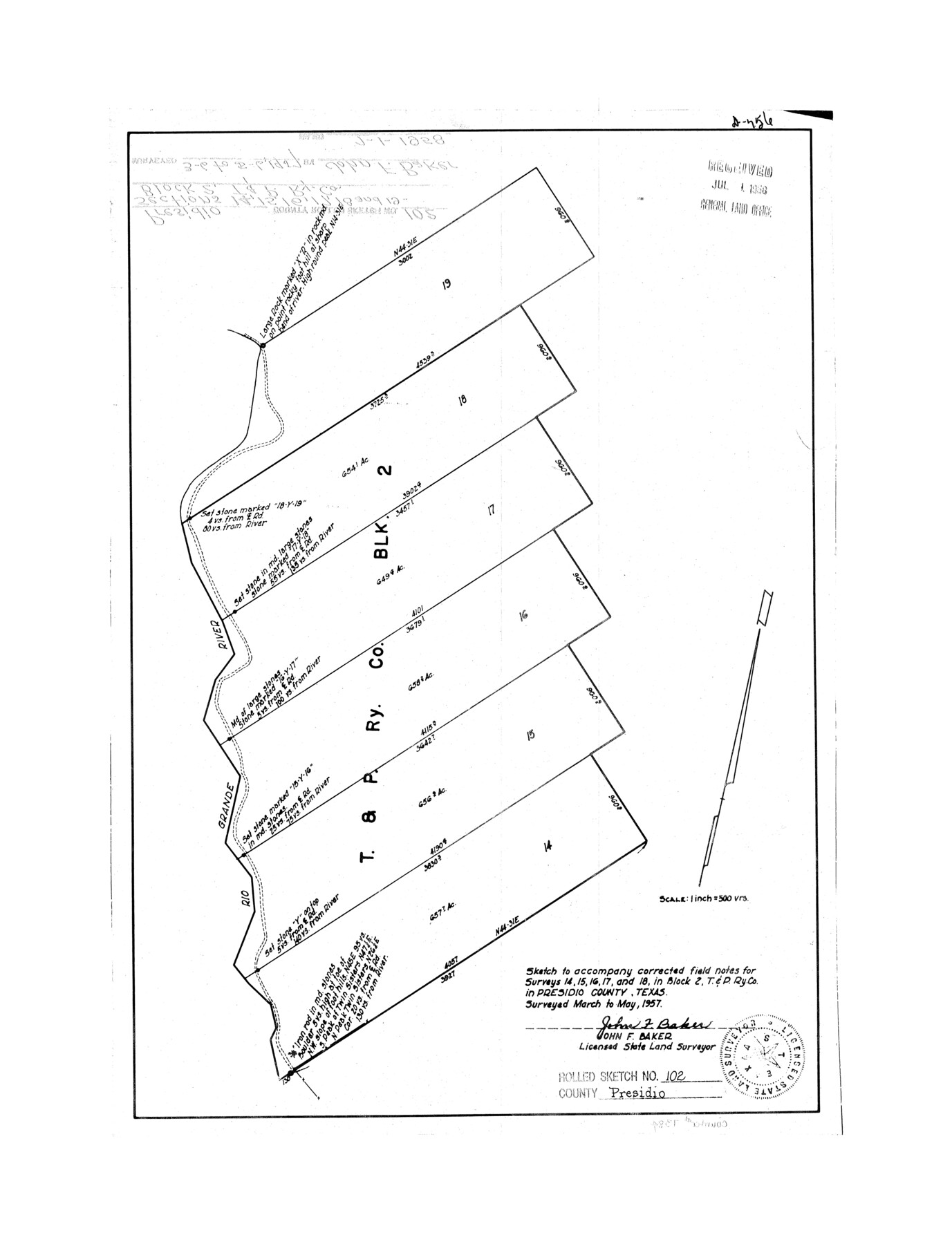
Presidio County Rolled Sketch 102
Sketch to accompany corrected field notes for surveys 14, 15, 16, 17, and 18 in Block 2, T. & P. Ry. Co. in Presidio County, Texas
-
Map/Doc
7384
-
Collection
General Map Collection
-
Object Dates
1957/5/6 (Creation Date)
1958/7/1 (File Date)
-
People and Organizations
John F. Baker (Surveyor/Engineer)
-
Counties
Presidio
-
Subjects
Surveying Rolled Sketch
-
Height x Width
22.8 x 17.4 inches
57.9 x 44.2 cm
-
Scale
1" = 500 varas
Part of: General Map Collection
Duval County Working Sketch 57

Print $20.00
- Digital $50.00
Duval County Working Sketch 57
1990
Size 30.3 x 25.4 inches
Map/Doc 68781
Crockett County Working Sketch 28

Print $20.00
- Digital $50.00
Crockett County Working Sketch 28
1923
Size 31.4 x 24.6 inches
Map/Doc 68361
Index sheet to accompany map of survey for connecting the inland waters along margin of the Gulf of Mexico from Donaldsonville in Louisiana to the Rio Grande River in Texas

Print $20.00
- Digital $50.00
Index sheet to accompany map of survey for connecting the inland waters along margin of the Gulf of Mexico from Donaldsonville in Louisiana to the Rio Grande River in Texas
Size 18.2 x 27.5 inches
Map/Doc 72691
Gregg County Boundary File 4

Print $14.00
- Digital $50.00
Gregg County Boundary File 4
Size 14.1 x 8.6 inches
Map/Doc 53992
Van Zandt County Sketch File 25

Print $4.00
- Digital $50.00
Van Zandt County Sketch File 25
Size 7.6 x 8.8 inches
Map/Doc 39443
Map of Upshur County Texas

Print $20.00
- Digital $50.00
Map of Upshur County Texas
1873
Size 20.4 x 15.2 inches
Map/Doc 4635
Glasscock County Sketch File 22

Print $20.00
- Digital $50.00
Glasscock County Sketch File 22
Size 13.8 x 18.6 inches
Map/Doc 11565
Marion County Rolled Sketch 4

Print $40.00
- Digital $50.00
Marion County Rolled Sketch 4
1951
Size 43.1 x 58.0 inches
Map/Doc 9491
Titus County Sketch File 12

Print $40.00
- Digital $50.00
Titus County Sketch File 12
1891
Size 14.9 x 14.2 inches
Map/Doc 38152
Flight Mission No. DIX-8P, Frame 59, Aransas County

Print $20.00
- Digital $50.00
Flight Mission No. DIX-8P, Frame 59, Aransas County
1956
Size 18.7 x 22.4 inches
Map/Doc 83890
Liberty County Working Sketch 41

Print $20.00
- Digital $50.00
Liberty County Working Sketch 41
1953
Size 21.4 x 20.8 inches
Map/Doc 70500
Hays County Rolled Sketch 30

Print $20.00
- Digital $50.00
Hays County Rolled Sketch 30
1966
Size 33.1 x 36.6 inches
Map/Doc 9150
You may also like
Texas Gulf Coast, from the Sabine River to the Rio Grande as Subdivided for Mineral Development; Jefferson, Chambers and Galveston Counties

Print $20.00
- Digital $50.00
Texas Gulf Coast, from the Sabine River to the Rio Grande as Subdivided for Mineral Development; Jefferson, Chambers and Galveston Counties
1976
Size 29.0 x 42.5 inches
Map/Doc 1937

2008 Official Travel Map, Texas

2008 Official Travel Map, Texas
Size 33.4 x 36.5 inches
Map/Doc 94343
Starr County Sketch File 15

Print $10.00
- Digital $50.00
Starr County Sketch File 15
Size 12.1 x 7.4 inches
Map/Doc 36869
Webb County Working Sketch 87

Print $20.00
- Digital $50.00
Webb County Working Sketch 87
1981
Size 46.3 x 39.6 inches
Map/Doc 72454
Tom Green County Sketch File 69

Print $40.00
- Digital $50.00
Tom Green County Sketch File 69
1945
Size 16.5 x 12.4 inches
Map/Doc 38239
Map of Rock Island Lines and Connections - Route of Golden State Limited to California / Rocky Mountain Limited to Colorado

Print $20.00
- Digital $50.00
Map of Rock Island Lines and Connections - Route of Golden State Limited to California / Rocky Mountain Limited to Colorado
1923
Size 18.3 x 32.6 inches
Map/Doc 95890
Brooks County Sketch File 11

Print $14.00
- Digital $50.00
Brooks County Sketch File 11
Size 11.3 x 8.9 inches
Map/Doc 16573
Coleman County Sketch File 34

Print $28.00
- Digital $50.00
Coleman County Sketch File 34
1878
Size 12.8 x 8.1 inches
Map/Doc 18726
Castro County Sketch File 11

Print $2.00
- Digital $50.00
Castro County Sketch File 11
1935
Size 11.4 x 7.1 inches
Map/Doc 17504
Sulphur River, Talco Sheet

Print $20.00
- Digital $50.00
Sulphur River, Talco Sheet
1917
Size 24.6 x 43.7 inches
Map/Doc 65160
Duval County Rolled Sketch 45

Print $20.00
- Digital $50.00
Duval County Rolled Sketch 45
1982
Size 36.3 x 24.5 inches
Map/Doc 5760