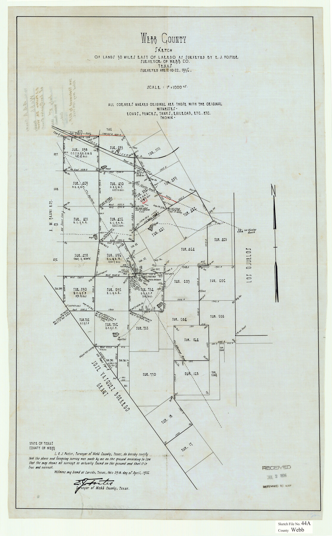
Webb County Sketch File 44a
Webb County sketch of lands [northeast of the Borrego grant in the southeast part of the county]
-
Map/Doc
12640
-
Collection
General Map Collection
-
Object Dates
4/29/1936 (Creation Date)
7/2/1936 (File Date)
4/10-22/1936 (Survey Date)
-
People and Organizations
E.J. Foster (Surveyor/Engineer)
-
Counties
Webb
-
Subjects
Surveying Sketch File
-
Height x Width
29.4 x 18.2 inches
74.7 x 46.2 cm
-
Medium
paper, manuscript
-
Scale
1" = 1000 varas
-
Comments
See Webb County Sketch File 44b (39829) for surveyor's statement.
-
Features
Los Ojuelos Ranch Road
Los Ojuelos Ranch
TMRR
Related maps
Webb County Sketch File 44b

Print $8.00
- Digital $50.00
Webb County Sketch File 44b
1936
Size 14.5 x 9.0 inches
Map/Doc 39829
Part of: General Map Collection
[Map of Hunt County]
![3691, [Map of Hunt County], General Map Collection](https://historictexasmaps.com/wmedia_w700/maps/3691-1.tif.jpg)
Print $20.00
- Digital $50.00
[Map of Hunt County]
1851
Size 21.6 x 19.1 inches
Map/Doc 3691
[Sketch for Mineral Application 24070 - Smith and Wood Counties, R. A. Tofflemire]
![65643, [Sketch for Mineral Application 24070 - Smith and Wood Counties, R. A. Tofflemire], General Map Collection](https://historictexasmaps.com/wmedia_w700/maps/65643.tif.jpg)
Print $40.00
- Digital $50.00
[Sketch for Mineral Application 24070 - Smith and Wood Counties, R. A. Tofflemire]
1929
Size 42.7 x 226.9 inches
Map/Doc 65643
Topographical Map of the Rio Grande, Sheet No. 1

Print $20.00
- Digital $50.00
Topographical Map of the Rio Grande, Sheet No. 1
1912
Map/Doc 89525
Sabine Bank to East Bay including Heald Bank

Print $20.00
- Digital $50.00
Sabine Bank to East Bay including Heald Bank
1973
Size 44.8 x 34.5 inches
Map/Doc 69850
Gray County Sketch File B2

Print $20.00
- Digital $50.00
Gray County Sketch File B2
Size 22.8 x 17.3 inches
Map/Doc 11579
Map of Ramon Musquiz Survey, Meanders of Lavaca & Navidad Rivers, Menefee & Redfish Lakes

Print $20.00
- Digital $50.00
Map of Ramon Musquiz Survey, Meanders of Lavaca & Navidad Rivers, Menefee & Redfish Lakes
1934
Size 24.4 x 18.0 inches
Map/Doc 65453
Cameron County Sketch File 11

Print $58.00
- Digital $50.00
Cameron County Sketch File 11
1991
Size 11.0 x 7.9 inches
Map/Doc 17207
Trinity River, Ham Crossing Sheet/Waxahachie Creek

Print $6.00
- Digital $50.00
Trinity River, Ham Crossing Sheet/Waxahachie Creek
1930
Size 31.4 x 31.1 inches
Map/Doc 65235
Brazoria County NRC Article 33.136 Sketch 29

Print $24.00
Brazoria County NRC Article 33.136 Sketch 29
2025
Map/Doc 97474
Wise County Sketch File 7

Print $4.00
- Digital $50.00
Wise County Sketch File 7
1857
Size 8.1 x 14.0 inches
Map/Doc 40535
Stephens County Sketch File 26

Print $10.00
- Digital $50.00
Stephens County Sketch File 26
Size 14.1 x 8.8 inches
Map/Doc 37096
Terrell County Working Sketch 40

Print $20.00
- Digital $50.00
Terrell County Working Sketch 40
1956
Size 22.9 x 29.1 inches
Map/Doc 62133
You may also like

Williamson County Sketch File 1

Print $4.00
- Digital $50.00
Williamson County Sketch File 1
1847
Size 8.8 x 10.1 inches
Map/Doc 40299
[Blocks A, B and C]
![89867, [Blocks A, B and C], Twichell Survey Records](https://historictexasmaps.com/wmedia_w700/maps/89867-1.tif.jpg)
Print $40.00
- Digital $50.00
[Blocks A, B and C]
Size 36.0 x 59.0 inches
Map/Doc 89867
Johnson County Rolled Sketch 3

Print $20.00
- Digital $50.00
Johnson County Rolled Sketch 3
1990
Size 28.7 x 28.0 inches
Map/Doc 6448
Montgomery County Rolled Sketch 19A

Print $40.00
- Digital $50.00
Montgomery County Rolled Sketch 19A
1933
Size 52.9 x 37.3 inches
Map/Doc 8349
Right of Way and Track Map of The Missouri, Kansas & Texas Railway of Texas

Print $40.00
- Digital $50.00
Right of Way and Track Map of The Missouri, Kansas & Texas Railway of Texas
1918
Size 25.7 x 107.8 inches
Map/Doc 64532
Kendall County Working Sketch 9

Print $40.00
- Digital $50.00
Kendall County Working Sketch 9
1953
Size 52.8 x 37.2 inches
Map/Doc 66681
[Surveys along the Trinity River]
![330, [Surveys along the Trinity River], General Map Collection](https://historictexasmaps.com/wmedia_w700/maps/330.tif.jpg)
Print $2.00
- Digital $50.00
[Surveys along the Trinity River]
1846
Size 9.0 x 12.2 inches
Map/Doc 330
Kimble County Working Sketch 6

Print $20.00
- Digital $50.00
Kimble County Working Sketch 6
1915
Size 24.4 x 26.5 inches
Map/Doc 70074
Ector County Boundary File 2

Print $4.00
- Digital $50.00
Ector County Boundary File 2
Size 13.2 x 8.2 inches
Map/Doc 52834

Concho County Rolled Sketch 1

Print $20.00
- Digital $50.00
Concho County Rolled Sketch 1
1945
Size 19.5 x 25.0 inches
Map/Doc 5543