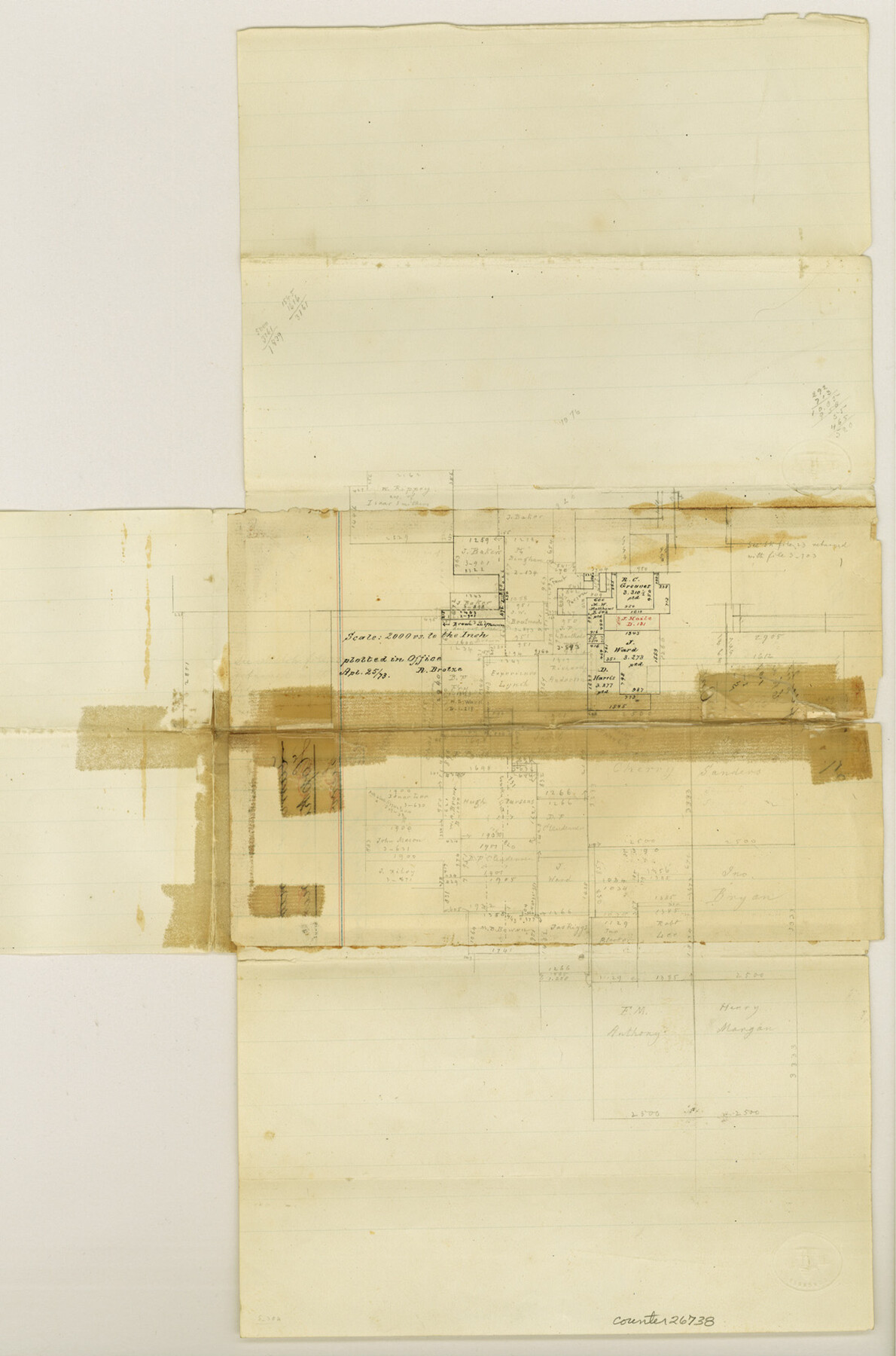
Hopkins County Sketch File 27
[Office sketch on west boundary line around the J. Ward survey]
-
Map/Doc
26738
-
Collection
General Map Collection
-
Object Dates
4/25/1873 (Creation Date)
-
People and Organizations
Brotze (Surveyor/Engineer)
-
Counties
Hopkins Hunt
-
Subjects
Surveying Sketch File
-
Height x Width
16.6 x 11.0 inches
42.2 x 27.9 cm
-
Medium
paper, manuscript
Part of: General Map Collection
Williamson County Sketch File 12

Print $4.00
- Digital $50.00
Williamson County Sketch File 12
1860
Size 12.6 x 3.4 inches
Map/Doc 40326
Lee County Sketch File 10

Print $10.00
- Digital $50.00
Lee County Sketch File 10
2009
Size 11.0 x 8.5 inches
Map/Doc 89289
Flight Mission No. CGI-3N, Frame 178, Cameron County

Print $20.00
- Digital $50.00
Flight Mission No. CGI-3N, Frame 178, Cameron County
1954
Size 18.5 x 22.2 inches
Map/Doc 84642
[San Antonio & Aransas Pass]
![64211, [San Antonio & Aransas Pass], General Map Collection](https://historictexasmaps.com/wmedia_w700/maps/64211.tif.jpg)
Print $2.00
- Digital $50.00
[San Antonio & Aransas Pass]
Size 11.6 x 8.2 inches
Map/Doc 64211
Travis County Appraisal District Plat Map 2_2512

Print $20.00
- Digital $50.00
Travis County Appraisal District Plat Map 2_2512
1938
Size 21.5 x 26.5 inches
Map/Doc 94216
Uvalde County Working Sketch 34

Print $20.00
- Digital $50.00
Uvalde County Working Sketch 34
1963
Size 31.6 x 42.8 inches
Map/Doc 72104
Preliminary Chart of Galveston Bay, Texas

Print $20.00
- Digital $50.00
Preliminary Chart of Galveston Bay, Texas
1855
Size 20.9 x 17.5 inches
Map/Doc 69868
Clay County Working Sketch 3

Print $20.00
- Digital $50.00
Clay County Working Sketch 3
1923
Size 19.7 x 9.3 inches
Map/Doc 68026
Orange County Sketch File 17

Print $50.00
- Digital $50.00
Orange County Sketch File 17
1922
Size 11.1 x 8.6 inches
Map/Doc 33337
Bandera County Rolled Sketch 5

Print $20.00
- Digital $50.00
Bandera County Rolled Sketch 5
1973
Size 19.8 x 31.0 inches
Map/Doc 5117
Aransas County Rolled Sketch 12

Print $20.00
- Digital $50.00
Aransas County Rolled Sketch 12
Size 17.6 x 11.1 inches
Map/Doc 77191
Matagorda County Sketch File 30

Print $20.00
- Digital $50.00
Matagorda County Sketch File 30
1911
Size 22.2 x 31.9 inches
Map/Doc 12045
You may also like
Johnson County

Print $20.00
- Digital $50.00
Johnson County
1874
Size 19.9 x 18.0 inches
Map/Doc 3736
Real County Working Sketch 21

Print $20.00
- Digital $50.00
Real County Working Sketch 21
1944
Size 24.8 x 35.7 inches
Map/Doc 71913
Moore County Working Sketch 8

Print $20.00
- Digital $50.00
Moore County Working Sketch 8
1948
Size 23.2 x 31.8 inches
Map/Doc 71190
Township 1 South Range 11 West, South Western District, Louisiana

Print $20.00
- Digital $50.00
Township 1 South Range 11 West, South Western District, Louisiana
1881
Size 19.7 x 24.8 inches
Map/Doc 65879
Flight Mission No. DCL-7C, Frame 6, Kenedy County

Print $20.00
- Digital $50.00
Flight Mission No. DCL-7C, Frame 6, Kenedy County
1943
Size 15.5 x 15.4 inches
Map/Doc 85998
Supreme Court of the United States, October Term, 1924, No. 13, Original - The State of Oklahoma, Complainant vs. The State of Texas, Defendant, The United States, Intervener

Print $20.00
- Digital $50.00
Supreme Court of the United States, October Term, 1924, No. 13, Original - The State of Oklahoma, Complainant vs. The State of Texas, Defendant, The United States, Intervener
1924
Size 26.5 x 38.5 inches
Map/Doc 75131
Edwards County Boundary File 27 1/2a

Print $56.00
- Digital $50.00
Edwards County Boundary File 27 1/2a
Size 14.1 x 8.8 inches
Map/Doc 52922
Hidalgo County Sketch File 8

Print $4.00
- Digital $50.00
Hidalgo County Sketch File 8
1890
Size 14.1 x 8.6 inches
Map/Doc 26407
Concho, San Saba & Llano Valley Railway, Sterling City Branch, Texas. Right of Way and Track Map

Print $40.00
- Digital $50.00
Concho, San Saba & Llano Valley Railway, Sterling City Branch, Texas. Right of Way and Track Map
1910
Size 17.7 x 57.8 inches
Map/Doc 64437
Aransas County Sketch File B

Print $4.00
- Digital $50.00
Aransas County Sketch File B
Size 6.9 x 11.4 inches
Map/Doc 13216
Sketch of a portion of the Texas Coast showing the relative positions of different harbours with the interior Military Posts, and the roads communicating with them, also two new routes from Black Point and Lamar to San Antonio

Print $20.00
- Digital $50.00
Sketch of a portion of the Texas Coast showing the relative positions of different harbours with the interior Military Posts, and the roads communicating with them, also two new routes from Black Point and Lamar to San Antonio
1855
Size 27.3 x 18.3 inches
Map/Doc 72710
Duval County Sketch File 77

Print $20.00
- Digital $50.00
Duval County Sketch File 77
1967
Size 20.4 x 15.5 inches
Map/Doc 11411