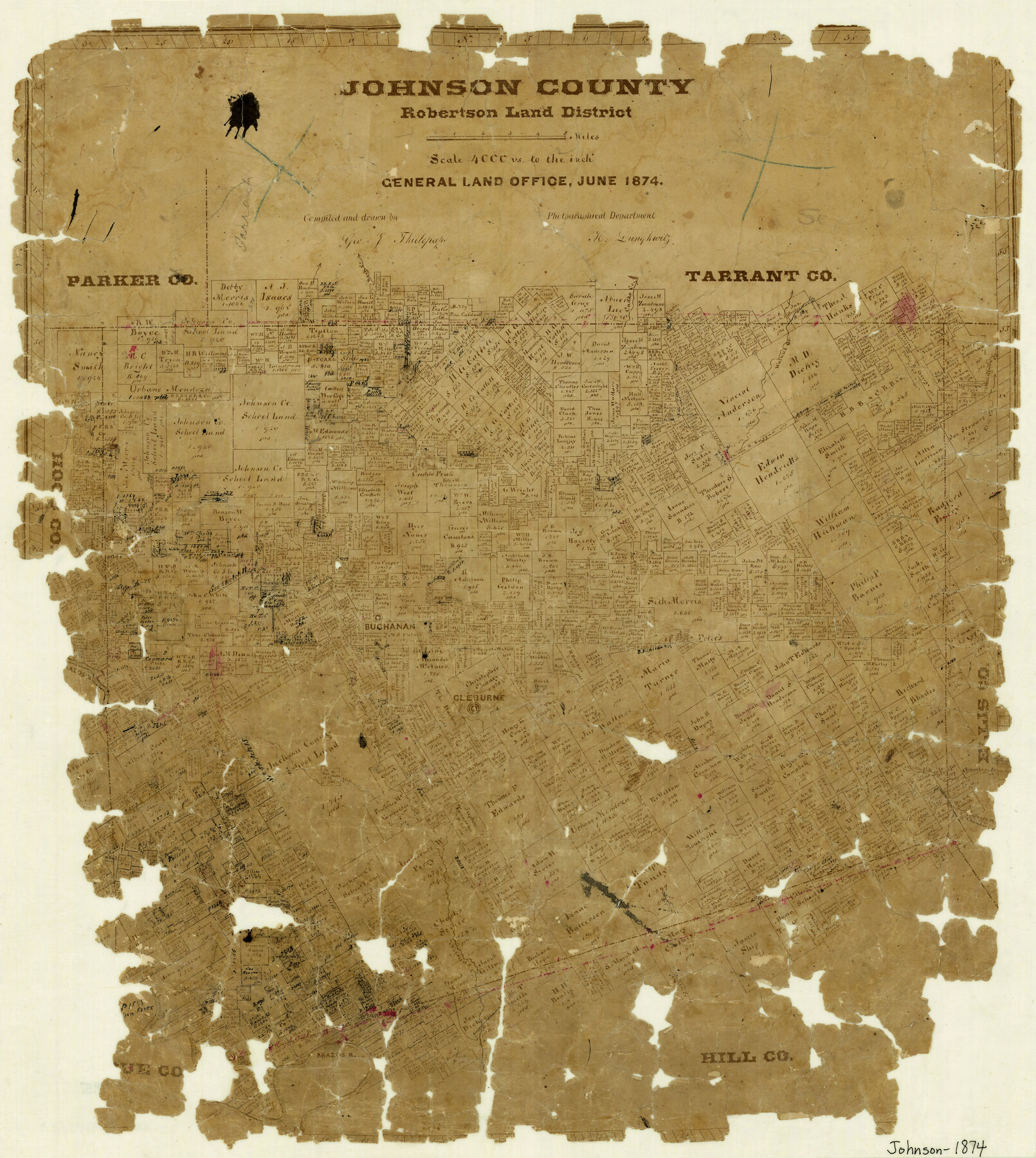
Johnson County
-
Map/Doc
3736
-
Collection
General Map Collection
-
Object Dates
6/1874 (Creation Date)
-
People and Organizations
Herman Lungkwitz (Draftsman)
George J. Thielepape (Compiler)
-
Counties
Johnson
-
Subjects
County
-
Height x Width
19.9 x 18.0 inches
50.6 x 45.7 cm
-
Features
Rock Creek
Caddo Creek
Walnut Creek
Elm Creek
Mountain Creek
Brazos River
Willow Creek
Buchanan
Cleburne
North Fork of Chambers Creek
South Fork of Chambers Creek
Nolands Creek
Mustang Creek
Mitchells Creek
Aquila Creek
Part of: General Map Collection
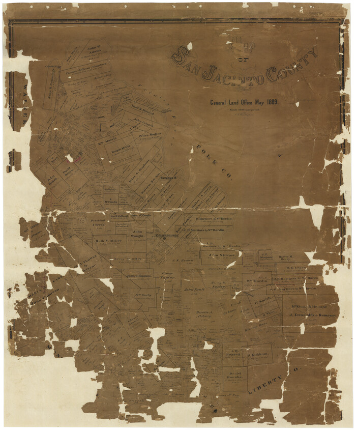
Map of San Jacinto County
Print $20.00
- Digital $50.00
Map of San Jacinto County
1889
Size 43.8 x 37.0 inches
Map/Doc 16808
Roberts County Rolled Sketch 3

Print $40.00
- Digital $50.00
Roberts County Rolled Sketch 3
Size 38.0 x 49.7 inches
Map/Doc 8354
Bailey County Working Sketch 1

Print $20.00
- Digital $50.00
Bailey County Working Sketch 1
1920
Size 28.9 x 10.5 inches
Map/Doc 67588
Kingston South Quadrangle

Print $20.00
- Digital $50.00
Kingston South Quadrangle
1999
Size 35.4 x 23.4 inches
Map/Doc 97364
Haskell County Working Sketch 8

Print $20.00
- Digital $50.00
Haskell County Working Sketch 8
1957
Size 22.8 x 24.0 inches
Map/Doc 66066
Flight Mission No. DAG-24K, Frame 36, Matagorda County

Print $20.00
- Digital $50.00
Flight Mission No. DAG-24K, Frame 36, Matagorda County
1953
Size 18.5 x 22.2 inches
Map/Doc 86523
Lamb County Sketch File 12

Print $16.00
- Digital $50.00
Lamb County Sketch File 12
Size 8.6 x 7.7 inches
Map/Doc 29363
Crockett County Rolled Sketch 91

Print $40.00
- Digital $50.00
Crockett County Rolled Sketch 91
1928
Size 26.0 x 63.9 inches
Map/Doc 9033
Tarrant County Working Sketch 2

Print $20.00
- Digital $50.00
Tarrant County Working Sketch 2
1940
Size 21.3 x 19.5 inches
Map/Doc 62419
Hutchinson County Working Sketch 36

Print $20.00
- Digital $50.00
Hutchinson County Working Sketch 36
1978
Size 27.2 x 22.4 inches
Map/Doc 66396
Hays County Sketch File 5

Print $4.00
- Digital $50.00
Hays County Sketch File 5
1847
Size 12.7 x 8.3 inches
Map/Doc 26206
Ector County Working Sketch 32

Print $20.00
- Digital $50.00
Ector County Working Sketch 32
1981
Size 26.2 x 17.0 inches
Map/Doc 68875
You may also like
W. S. Mabry Land Corners and Connections, Potter County

Print $20.00
- Digital $50.00
W. S. Mabry Land Corners and Connections, Potter County
Size 22.4 x 17.4 inches
Map/Doc 91805
Flight Mission No. DQO-8K, Frame 112, Galveston County

Print $20.00
- Digital $50.00
Flight Mission No. DQO-8K, Frame 112, Galveston County
1952
Size 18.6 x 22.4 inches
Map/Doc 85194
Denton County Sketch File 12

Print $4.00
- Digital $50.00
Denton County Sketch File 12
1856
Size 8.3 x 10.3 inches
Map/Doc 20711

Sutton County Working Sketch 47

Print $20.00
- Digital $50.00
Sutton County Working Sketch 47
1954
Size 34.3 x 21.3 inches
Map/Doc 62390
![91461, [Block B7], Twichell Survey Records](https://historictexasmaps.com/wmedia_w700/maps/91461-1.tif.jpg)
Jim Wells County Working Sketch 7

Print $20.00
- Digital $50.00
Jim Wells County Working Sketch 7
1944
Size 26.2 x 29.3 inches
Map/Doc 66605
Galveston County Rolled Sketch 22

Print $20.00
- Digital $50.00
Galveston County Rolled Sketch 22
1953
Size 29.6 x 40.8 inches
Map/Doc 9083
Hale County Boundary File 1

Print $44.00
- Digital $50.00
Hale County Boundary File 1
Size 10.0 x 30.9 inches
Map/Doc 54031
Flight Mission No. BRA-8M, Frame 122, Jefferson County

Print $20.00
- Digital $50.00
Flight Mission No. BRA-8M, Frame 122, Jefferson County
1953
Size 18.5 x 22.4 inches
Map/Doc 85618
Val Verde County Sketch File 31

Print $18.00
- Digital $50.00
Val Verde County Sketch File 31
1922
Size 11.2 x 9.0 inches
Map/Doc 39240
Chart of the West Indies and Spanish Dominions in North America

Print $20.00
- Digital $50.00
Chart of the West Indies and Spanish Dominions in North America
1803
Size 25.3 x 38.4 inches
Map/Doc 97136