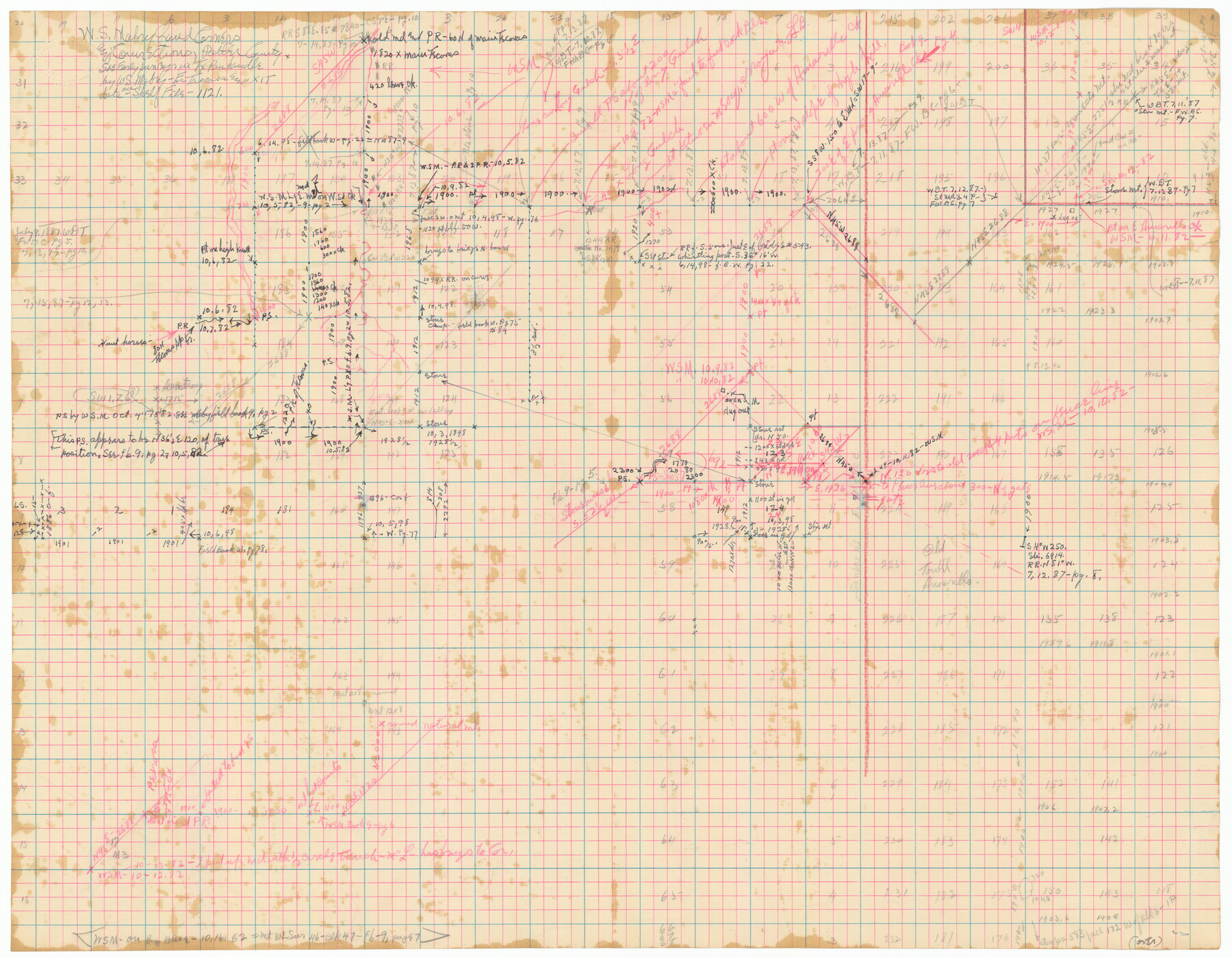
W. S. Mabry Land Corners and Connections, Potter County
188-38
-
Map/Doc
91805
-
Collection
Twichell Survey Records
-
Counties
Potter
-
Height x Width
22.4 x 17.4 inches
56.9 x 44.2 cm
-
Comments
See counter 91806 for XIT Historical notes on back.
Part of: Twichell Survey Records

[Sketch showing B. S. & F. Blks B1 and B2 and surrounding Blocks]
![90137, [Sketch showing B. S. & F. Blks B1 and B2 and surrounding Blocks], Twichell Survey Records](https://historictexasmaps.com/wmedia_w700/maps/90137-1.tif.jpg)
Print $20.00
- Digital $50.00
[Sketch showing B. S. & F. Blks B1 and B2 and surrounding Blocks]
Size 23.3 x 18.3 inches
Map/Doc 90137
Terrell County

Print $20.00
- Digital $50.00
Terrell County
1905
Size 30.7 x 33.8 inches
Map/Doc 92806
Plat of Littlefield, Texas

Print $20.00
- Digital $50.00
Plat of Littlefield, Texas
Size 23.6 x 19.3 inches
Map/Doc 90990
McLaughlin Farm, Crosby County, Texas

Print $20.00
- Digital $50.00
McLaughlin Farm, Crosby County, Texas
1952
Size 14.3 x 14.1 inches
Map/Doc 92615
[Yates Field showing well locations]
![91670, [Yates Field showing well locations], Twichell Survey Records](https://historictexasmaps.com/wmedia_w700/maps/91670-1.tif.jpg)
Print $3.00
- Digital $50.00
[Yates Field showing well locations]
Size 14.4 x 11.3 inches
Map/Doc 91670
[Southeast part of Block D and Blocks DD, C31-C37, AX, G and H]
![92012, [Southeast part of Block D and Blocks DD, C31-C37, AX, G and H], Twichell Survey Records](https://historictexasmaps.com/wmedia_w700/maps/92012-1.tif.jpg)
Print $20.00
- Digital $50.00
[Southeast part of Block D and Blocks DD, C31-C37, AX, G and H]
Size 21.4 x 15.0 inches
Map/Doc 92012
[Strip between Block 8 and Block K4]
![90601, [Strip between Block 8 and Block K4], Twichell Survey Records](https://historictexasmaps.com/wmedia_w700/maps/90601-1.tif.jpg)
Print $2.00
- Digital $50.00
[Strip between Block 8 and Block K4]
Size 8.8 x 11.7 inches
Map/Doc 90601
[B. S. & F. Block B]
![91250, [B. S. & F. Block B], Twichell Survey Records](https://historictexasmaps.com/wmedia_w700/maps/91250-1.tif.jpg)
Print $3.00
- Digital $50.00
[B. S. & F. Block B]
Size 11.2 x 17.8 inches
Map/Doc 91250
[Sketch of part of G. & M. Block 5, G. & M. Block 4, Block M19 and Block 21W]
![93079, [Sketch of part of G. & M. Block 5, G. & M. Block 4, Block M19 and Block 21W], Twichell Survey Records](https://historictexasmaps.com/wmedia_w700/maps/93079-1.tif.jpg)
Print $20.00
- Digital $50.00
[Sketch of part of G. & M. Block 5, G. & M. Block 4, Block M19 and Block 21W]
Size 22.8 x 15.6 inches
Map/Doc 93079
Counties of Martin, Dawson, Borden, and Howard, Texas Soash Lands, Big Springs Ranch

Print $20.00
- Digital $50.00
Counties of Martin, Dawson, Borden, and Howard, Texas Soash Lands, Big Springs Ranch
Size 35.3 x 39.0 inches
Map/Doc 91224
University of Texas System University Lands

Print $20.00
- Digital $50.00
University of Texas System University Lands
Size 23.2 x 17.6 inches
Map/Doc 93235
You may also like
Reconnoissance of Sabine River and Valley

Print $20.00
Reconnoissance of Sabine River and Valley
1863
Size 30.4 x 42.5 inches
Map/Doc 97498
McMullen County Working Sketch 22

Print $40.00
- Digital $50.00
McMullen County Working Sketch 22
1947
Size 39.1 x 53.3 inches
Map/Doc 70723
J. De Cordova's Map of the State of Texas Compiled from the records of the General Land Office of the State

Print $20.00
- Digital $50.00
J. De Cordova's Map of the State of Texas Compiled from the records of the General Land Office of the State
1849
Size 36.0 x 34.0 inches
Map/Doc 93930
Harris County Historic Topographic 6

Print $20.00
- Digital $50.00
Harris County Historic Topographic 6
1916
Size 29.9 x 22.8 inches
Map/Doc 65816
Starr County Rolled Sketch 46B

Print $20.00
- Digital $50.00
Starr County Rolled Sketch 46B
1986
Size 17.9 x 34.5 inches
Map/Doc 7838
South Part of Brewster Co.

Print $20.00
- Digital $50.00
South Part of Brewster Co.
1955
Size 47.3 x 39.6 inches
Map/Doc 77221
"Texas New Yorker's" Railroad Map of Texas

Print $20.00
"Texas New Yorker's" Railroad Map of Texas
1874
Size 22.8 x 32.3 inches
Map/Doc 76210
Flight Mission No. BQR-9K, Frame 51, Brazoria County

Print $20.00
- Digital $50.00
Flight Mission No. BQR-9K, Frame 51, Brazoria County
1952
Size 18.9 x 22.4 inches
Map/Doc 84055
Current Miscellaneous File 82

Print $4.00
- Digital $50.00
Current Miscellaneous File 82
Size 12.0 x 8.8 inches
Map/Doc 74224
Jefferson County Working Sketch 16

Print $20.00
- Digital $50.00
Jefferson County Working Sketch 16
1954
Size 31.0 x 18.8 inches
Map/Doc 66559
First Addition to Amherst Suburban Farms

Print $20.00
- Digital $50.00
First Addition to Amherst Suburban Farms
Size 26.5 x 20.6 inches
Map/Doc 92430
Mapa del Rio Grande desde su Desembocadura en el Golfo hasta San Vicente, Presidio Antíguo

Print $20.00
- Digital $50.00
Mapa del Rio Grande desde su Desembocadura en el Golfo hasta San Vicente, Presidio Antíguo
1873
Size 38.1 x 32.3 inches
Map/Doc 97126