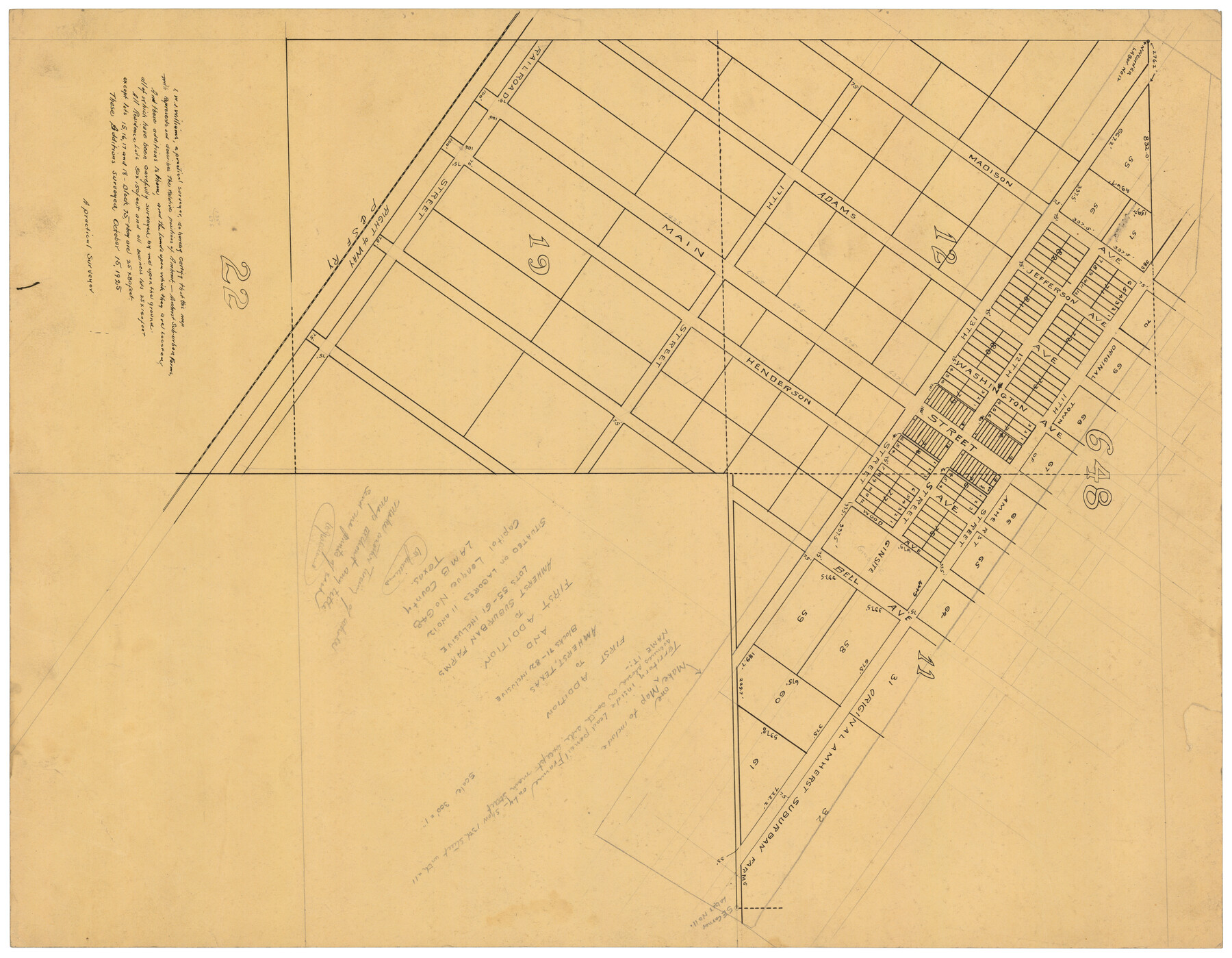
First Addition to Amherst Suburban Farms
-
Map/Doc
92430
-
Collection
Twichell Survey Records
-
People and Organizations
W.J. Williams (Surveyor/Engineer)
-
Counties
Lamb
-
Height x Width
26.5 x 20.6 inches
67.3 x 52.3 cm
Part of: Twichell Survey Records
[PSL A31-A26-A23]
![92451, [PSL A31-A26-A23], Twichell Survey Records](https://historictexasmaps.com/wmedia_w700/maps/92451-1.tif.jpg)
Print $20.00
- Digital $50.00
[PSL A31-A26-A23]
Size 23.7 x 19.3 inches
Map/Doc 92451
Portion of Pecos County

Print $20.00
- Digital $50.00
Portion of Pecos County
Size 18.8 x 21.6 inches
Map/Doc 91589
Ownership Map Lamb County

Print $20.00
- Digital $50.00
Ownership Map Lamb County
1934
Size 37.6 x 45.0 inches
Map/Doc 89847
[Capitol Leagues in Lamb County]
![91015, [Capitol Leagues in Lamb County], Twichell Survey Records](https://historictexasmaps.com/wmedia_w700/maps/91015-1.tif.jpg)
Print $2.00
- Digital $50.00
[Capitol Leagues in Lamb County]
1912
Size 12.3 x 8.8 inches
Map/Doc 91015

[PSL Blocks A6-A12]
![89780, [PSL Blocks A6-A12], Twichell Survey Records](https://historictexasmaps.com/wmedia_w700/maps/89780-1.tif.jpg)
Print $40.00
- Digital $50.00
[PSL Blocks A6-A12]
Size 23.2 x 64.7 inches
Map/Doc 89780
East Line of Lipscomb County

Print $20.00
- Digital $50.00
East Line of Lipscomb County
Size 8.9 x 21.7 inches
Map/Doc 91317
Portion of Scurry County

Print $20.00
- Digital $50.00
Portion of Scurry County
1882
Size 35.1 x 25.3 inches
Map/Doc 92923
Post City and Surroundings Showing Improvements and 4 Sec. Pastures

Print $20.00
- Digital $50.00
Post City and Surroundings Showing Improvements and 4 Sec. Pastures
1911
Size 36.4 x 29.8 inches
Map/Doc 90858
Robertson & Scott V Ranch situated in Crosby County, Texas

Print $40.00
- Digital $50.00
Robertson & Scott V Ranch situated in Crosby County, Texas
Size 41.2 x 48.8 inches
Map/Doc 89758
Western Cotton Oil Co. Property Lamb County, Texas

Print $20.00
- Digital $50.00
Western Cotton Oil Co. Property Lamb County, Texas
1951
Size 20.9 x 16.9 inches
Map/Doc 92166
[Blocks C-25, C-26, C-27, and 29]
![91320, [Blocks C-25, C-26, C-27, and 29], Twichell Survey Records](https://historictexasmaps.com/wmedia_w700/maps/91320-1.tif.jpg)
Print $20.00
- Digital $50.00
[Blocks C-25, C-26, C-27, and 29]
Size 23.4 x 27.2 inches
Map/Doc 91320
You may also like
Runnels County Working Sketch 23

Print $20.00
- Digital $50.00
Runnels County Working Sketch 23
1953
Size 34.7 x 31.4 inches
Map/Doc 63619
[Sketch showing J.S. Brooks, W.B. Aldredge, Madison County School Land and Others]
![89730, [Sketch showing J.S. Brooks, W.B. Aldredge, Madison County School Land and Others], Twichell Survey Records](https://historictexasmaps.com/wmedia_w700/maps/89730-1.tif.jpg)
Print $20.00
- Digital $50.00
[Sketch showing J.S. Brooks, W.B. Aldredge, Madison County School Land and Others]
Size 37.1 x 39.9 inches
Map/Doc 89730
The Republic County of Houston. January 30, 1841

Print $20.00
The Republic County of Houston. January 30, 1841
2020
Size 19.7 x 21.8 inches
Map/Doc 96179
Nueces County NRC Article 33.136 Sketch 21

Print $22.00
Nueces County NRC Article 33.136 Sketch 21
2023
Map/Doc 97087
Map of Asia engraved to illustrate Mitchell's school and family geography (Inset: Map of Palestine or the Holy Land)

Print $20.00
- Digital $50.00
Map of Asia engraved to illustrate Mitchell's school and family geography (Inset: Map of Palestine or the Holy Land)
1839
Size 9.5 x 11.8 inches
Map/Doc 93506
Victoria County Working Sketch 10

Print $20.00
- Digital $50.00
Victoria County Working Sketch 10
1964
Size 36.9 x 45.4 inches
Map/Doc 72280
Howard County Boundary File 4a

Print $60.00
- Digital $50.00
Howard County Boundary File 4a
Size 70.6 x 10.0 inches
Map/Doc 55166
Map of the State of Texas

Print $40.00
- Digital $50.00
Map of the State of Texas
1879
Size 102.7 x 57.6 inches
Map/Doc 93383
Terrell County Working Sketch 61

Print $20.00
- Digital $50.00
Terrell County Working Sketch 61
1962
Size 20.3 x 34.3 inches
Map/Doc 69582

Upton County Sketch File 4

Print $40.00
- Digital $50.00
Upton County Sketch File 4
1886
Size 19.5 x 9.0 inches
Map/Doc 12510
Runnels County Sketch File 3

Print $4.00
Runnels County Sketch File 3
1871
Size 13.0 x 8.1 inches
Map/Doc 35432