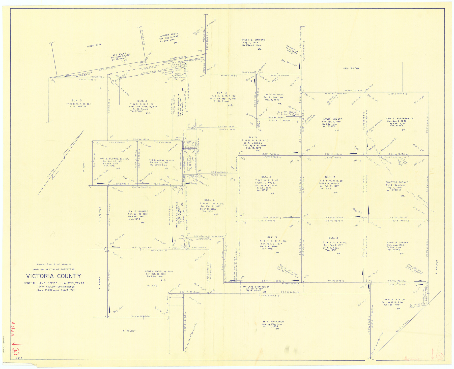
Victoria County Working Sketch 10
-
Map/Doc
72280
-
Collection
General Map Collection
-
Object Dates
8/18/1964 (Creation Date)
-
Counties
Victoria
-
Subjects
Surveying Working Sketch
-
Height x Width
36.9 x 45.4 inches
93.7 x 115.3 cm
-
Scale
1" = 300 varas
Part of: General Map Collection
Surveyors report on resurvey of Capitol Leagues in three parts, also copy of judgement of the District Court, Travis County

Print $20.00
- Digital $50.00
Surveyors report on resurvey of Capitol Leagues in three parts, also copy of judgement of the District Court, Travis County
Size 12.3 x 15.8 inches
Map/Doc 62579
Map of the Houston and G. N. R.R. and lands adjacent, from Troupe to the Texas Pacific R.R.

Print $40.00
- Digital $50.00
Map of the Houston and G. N. R.R. and lands adjacent, from Troupe to the Texas Pacific R.R.
Size 21.2 x 92.0 inches
Map/Doc 64627
Newton County Sketch File 2

Print $6.00
- Digital $50.00
Newton County Sketch File 2
Size 14.0 x 10.7 inches
Map/Doc 32358
Palo Pinto County Rolled Sketch 4

Print $20.00
- Digital $50.00
Palo Pinto County Rolled Sketch 4
Size 15.9 x 23.2 inches
Map/Doc 7189
Wise County Rolled Sketch 9

Print $20.00
- Digital $50.00
Wise County Rolled Sketch 9
Size 35.2 x 24.2 inches
Map/Doc 93640
Stonewall County Rolled Sketch 24A

Print $40.00
- Digital $50.00
Stonewall County Rolled Sketch 24A
1954
Size 55.0 x 47.1 inches
Map/Doc 9963
Zapata County Rolled Sketch 28

Print $20.00
- Digital $50.00
Zapata County Rolled Sketch 28
Size 35.5 x 35.3 inches
Map/Doc 10174
Marion County Sketch File 12

Print $20.00
- Digital $50.00
Marion County Sketch File 12
1912
Size 25.1 x 14.2 inches
Map/Doc 12022
Gregg County Sketch File 7

Print $20.00
- Digital $50.00
Gregg County Sketch File 7
1931
Size 42.9 x 34.8 inches
Map/Doc 10466
Duval County Sketch File 20a

Print $5.00
- Digital $50.00
Duval County Sketch File 20a
Size 9.2 x 11.4 inches
Map/Doc 21322
Van Zandt County Sketch File A45

Print $40.00
- Digital $50.00
Van Zandt County Sketch File A45
Size 14.2 x 13.7 inches
Map/Doc 39501
Brazoria County NRC Article 33.136 Sketch 9

Print $24.00
- Digital $50.00
Brazoria County NRC Article 33.136 Sketch 9
2007
Size 24.2 x 34.1 inches
Map/Doc 87929
You may also like
General Highway Map, Harris County, Texas

Print $20.00
General Highway Map, Harris County, Texas
1939
Size 24.7 x 18.4 inches
Map/Doc 79115
Map of Coryell Co.

Print $40.00
- Digital $50.00
Map of Coryell Co.
1896
Size 49.8 x 43.1 inches
Map/Doc 4921
Sketch Showing Surveys Made for W. R. Cartledge

Print $20.00
- Digital $50.00
Sketch Showing Surveys Made for W. R. Cartledge
1945
Size 16.9 x 14.4 inches
Map/Doc 2059
Jackson County Rolled Sketch 7

Print $20.00
- Digital $50.00
Jackson County Rolled Sketch 7
1940
Size 23.0 x 32.2 inches
Map/Doc 6342
Aransas County Rolled Sketch 25A-25E

Print $20.00
- Digital $50.00
Aransas County Rolled Sketch 25A-25E
Size 24.6 x 39.5 inches
Map/Doc 76078
Dawson County

Print $20.00
- Digital $50.00
Dawson County
1900
Size 40.5 x 36.3 inches
Map/Doc 66798
Anderson County Working Sketch 37

Print $20.00
- Digital $50.00
Anderson County Working Sketch 37
1984
Size 18.2 x 24.4 inches
Map/Doc 67037
Leveland and Adjacent Subdivisions of League 28, Hood County School Land Hockley County, Texas

Print $40.00
- Digital $50.00
Leveland and Adjacent Subdivisions of League 28, Hood County School Land Hockley County, Texas
Size 42.4 x 50.4 inches
Map/Doc 89848
[Sketch Between Hemphill County and Oklahoma]
![89635, [Sketch Between Hemphill County and Oklahoma], Twichell Survey Records](https://historictexasmaps.com/wmedia_w700/maps/89635-1.tif.jpg)
Print $40.00
- Digital $50.00
[Sketch Between Hemphill County and Oklahoma]
Size 62.0 x 8.0 inches
Map/Doc 89635
Frio County Rolled Sketch 19

Print $20.00
- Digital $50.00
Frio County Rolled Sketch 19
1956
Size 35.1 x 40.4 inches
Map/Doc 8909
Washington County Sketch File 6

Print $20.00
- Digital $50.00
Washington County Sketch File 6
1901
Size 24.7 x 26.0 inches
Map/Doc 12602
Freestone County Rolled Sketch 1

Print $20.00
- Digital $50.00
Freestone County Rolled Sketch 1
1947
Size 28.1 x 26.0 inches
Map/Doc 5909